- Home
- :
- All Communities
- :
- User Groups
- :
- Conservation GIS
- :
- Documents
- :
- Paul Mjema, Tanzania 2020
- Subscribe to RSS Feed
- Mark as New
- Mark as Read
- Bookmark
- Subscribe
- Printer Friendly Page
- Report Inappropriate Content
Paul Mjema, Tanzania 2020
Paul Mjema, Tanzania 2020
Paul Mjema, The Jane Goodall Institute Tanzania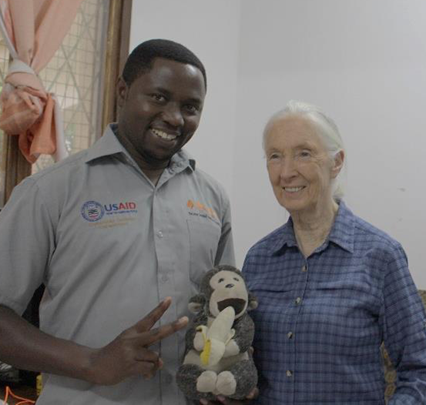
TACARE Education Center, Stanley Road – Kigoma Municipality
P.O Box 1182 Kigoma, Tanzania
My Organization, the Jane Goodall Institute is a global community conservation, Non-Governmental Organization that advances the vision and work of Dr. Jane Goodall. By protecting chimpanzees and inspiring people to conserve the natural world we all share, to improve the lives of people, animals and the environment.
The Jane Goodall institute has been implementing several conservation projects in Tanzania since 1990’s. What I do for them would really benefit from more capacity in leveraging GIS capabilities for enhancing conservation of endangered species of chimpanzees and their habitat in Western Tanzania. I am responsible for all GIS tasks on the ground and in the office to inform the project on threats, forest change, chimpanzee observations, in the project area. This is my third year with the Jane Goodall Institute.
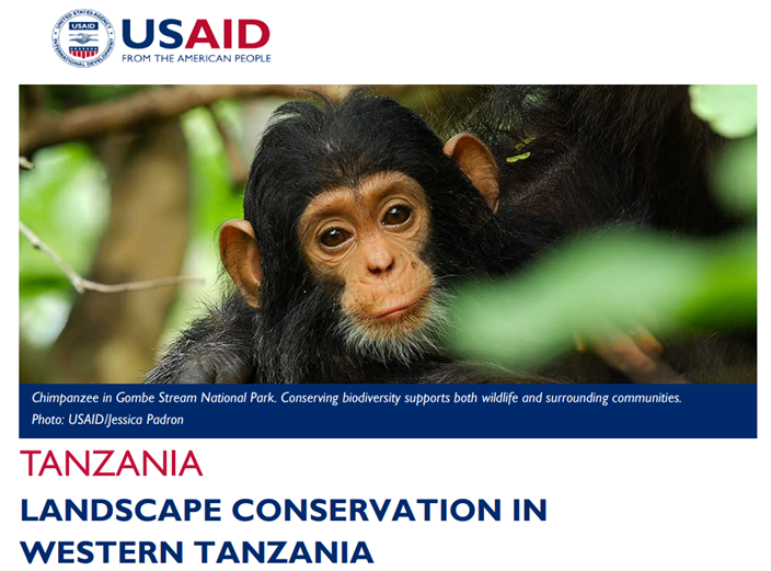
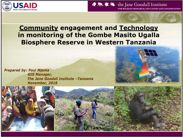
Currently the institute is implementing a five years conservation project known as “Landscape Conservation in Western Tanzania (LCWT)”. This project is funded by U.S Agency for International Development (USAID) and aims at protecting endangered chimpanzee populations, safeguard their habitat through effective land use planning, and empower local communities by supporting more productive livelihoods in the Gombe-Masito-Ugalla ecosystem. This ecosystem contains over 90% of Tanzania’s estimated 2,200 chimpanzees. This project uses modern GIS tools and technologies such as ArcGIS online, Survey 123 App and high-resolution Satellite Images in monitoring of chimpanzees and their habitat as well as in developing land use plans. In this project, I have managed to transfer skills of mobile data collection using a smartphone to 56 village forest monitoring volunteers by training and provide technical support on how to use Survey 123 app for field data collection. I coordinated the training and involved the Chief Scientist of JGI and volunteers from Esri East Africa and Evergreen University. After the training, I have been providing technical support and troubleshooting assistance whenever needed. Since launching of the field data collection tool in March 2019 to date, more than 13,000 survey forms have been uploaded to ArcGIS online and are used by decision makers and other partners to make conservation a reality.
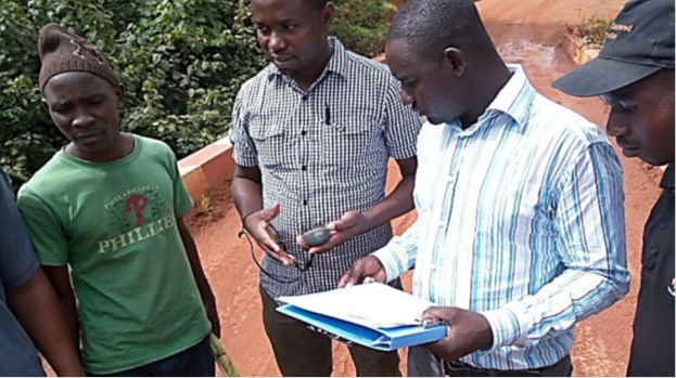
Figure 3. Field land use plan data collection with villagers
Additional GIS intensive courses are needed to improve the capacity of the GIS Manager position to be able to bridge technology and local knowledge in planning and monitoring of conservation targets (chimpanzee and their habitats). The need for this kind of training comes because the current project may support courses offered within the country (Tanzania). It is my hope that the SCGIS training program will expand my capacity and provide more capabilities to support the forest monitors in collecting field data and developing customized dashboards for easy data sharing among partners. Through this process the habitat will be constantly monitored and any threat tracked, chimpanzee presence recorded and known therefore protection efforts will be directed to areas with chimpanzees therefore achievement of project objective: conservation of chimpanzee and their habitat while empowering local communities.
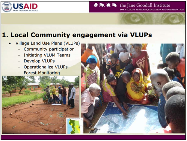
I have also been involved in mapping and developing land use plan frameworks for two districts. The districts are Uvinza and Tanganyika (in Western Tanzania) with a total area of 2,765,170 hectares. Before the current project, I was working in the same organization in a project known as Gombe Masito Ugalla (GMU) Project with a community centered and landscape scale conservation approach. Under this project I coordinated tasks of survey and mapping of 23 village land use plans from scratch to completion. I also supervised 56 village forest monitoring volunteers who by then used Open Data Kit (ODK) to collect field data when they go for monitoring their village forest reserves.
What is the most unique thing about the conservation/GIS work that you do?:
The most unique in what I am doing at my current project is coordinating Village Forest Monitoring program in the project area which is one of the longest ongoing community monitoring programs using mobile technologies in Africa. The program serves as a citizen science and crowdsourcing platform by providing monthly presence and absence of wildlife and threats data over the larger area. Currently there are 56 Forest Monitors (FMs) that LCWT Project works with. The FMs use smartphones and Survey123 Esri’s App for collecting data while monitoring their villages forest reserves. The data collected have GPS coordinates that enhances overlying them on satellite image to locate the point where data has been collected from. This program not only enhances application of technology for data capture but also empowers local communities in the villages around Gombe Masito Ugalla Landscape in Western Tanzania to be stewards of their own resources.
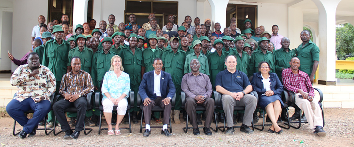
Figure 4. Forest Monitors in a group photo with the District Commissioner (in suit coat at the middle) after three days training in Mpanda Tanzania
They do monitor conservation targets and threats using standard protocols and mobile data collection tools that simplifies and improve cost effectiveness of data collection process. Under this program, I am responsible for coordinating and provide technical support to FMs. The most challenging issue is to enhance FMs to upload data on cloud server once they complete a day’s monitoring work. The challenge is that most villages that the project is working with have limited internet access therefore impossible to share forest monitoring data immediate after forest patrol. Instead the FMs upload data after three months by travel to district centers and connect WiFi internet to be able to upload their data. It is my hope that by attending the conference I may get new insights of how to enhance live data sharing from experts who works in remote areas.
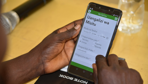
Figure 5. Forest Monitor filling in a test survey 123 form during training
HISTORY: Before joining The Jane Goodall Institute three years ago, I was working as GIS Analyst in a sanitation project. My tasks were to coordinate mapping of onsite sanitation facilities in Moshi Municipality in Kilimanjaro Region. The project aimed at understanding distribution of various sanitation facilities in the town so that the government can better plan and manage sanitation issues. In that project, we mapped more than 20,000 sanitation facilities. Before this job, during my master’s studies, my project was analysis of forest change on the slopes of Kilimanjaro Mountain. I this project, I used Landsat satellite images to understand forest change over time. I therefore performed image analysis to see the forest cover of western side of Kilimanjaro mountain between 2006 to 2013. This was very exiting project as it was one of early projects that gave me opportunity to apply GIS and Remote Sensing in real world. Before embarking on master’s study, I worked on two water supply projects in Dar Es Salaam City and Mtwara Town in Tanzania. My position in these water management projects I was GIS Analyst responsible for mapping water networks including its utilities such as water sources, pump stations, treatment plants, water tanks, district water meters, valves, connections and client’s properties.
In 2018 , I attended and made a presentation on the the 3rd Huangshan Dialogue on UNESCO Sites and Sustainable Development in Huanshang city of Anhui Province China in November 2018. Recently, I attended and presented a paper (in English) on the 5th Scientific Conference on Environmental Sustainability in Tanzania organized by the National Environment Management Council (NEMC) held in Arusha International Conference Center (AICC) in Tanzania in August 2019. The paper will be published on conference proceedings.
What is your connection to the local SCGIS chapter?: I am connected direct to Dr. Lilian Pintea, Vice President of Conservation Science for the Jane Goodall
Institute. He is my mentor, we work together in the current chimpanzee conservation project, and he has been working very close with Esri in applying new technologies in the field to achieve conservation goals.
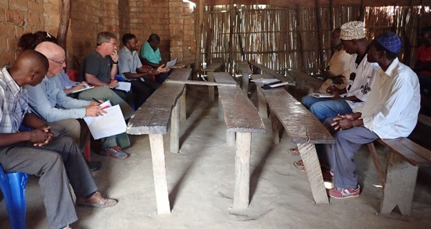
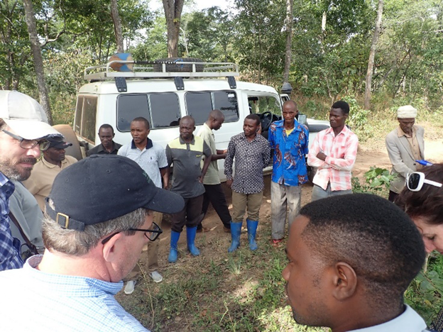
Figure 12. Meeting with village representative during Environmental Assessment
Do you have any experiences in teaching?
My teaching experience has been on GIS capacity building to local authority workers particularly foresters, natural resources officers, town planners and surveyors, in the four districts where my current project is focused. I am responsible for building their capacity in using various technological tools CAD or manual drawings when performing various mapping tasks. My role has been to make them know how they can use GIS to develop town plans with backdrop satellite images thus make plans that reflect the reality on the ground. My leadership experience is that, currently I am leading one of the Intermediate Results (IR) that deals with “Develop Regular Monitoring of Chimpanzee Health and Habitat Status” for the conservation project in Western Tanzania whereby I am responsible for planning and coordinating all activities under that IR. Before joining the Jane Goodall Institute, I was the coordinator leading the project for mapping of sanitation facilities for the entire municipality of Moshi town with population of more than 200,000 people.
GIS Background: I have six years’ experience of working as a GIS Analyst in four different projects. I have been using ArcGIS software, now ArcMap version 10.7.1. In addition, I have started learning using ArcGIS Pro because I know that Esri is now moving to this platform. In fact, I feel that I need more coaching from experts so that my transition from ArcGIS Desktop to ArcGIS Pro can be as smooth as possible. Its somehow a challenge for me to switch to ArcGIS Pro since I have been using ArcGIS Desktop software since when it was at version 9.2 to date.
In my work, I apply field to office GIS workflows to enhance easy and quick data capture, process and sharing for improving decision making in critical issues of natural resources management. I therefore use Survey 123 for field data collection whereby community forest monitoring volunteers use the app for field data collection and upload to ArcGIS online. Once data are uploaded, users’ groups within my organization with ArcGIS Online account can access the data in the dashboard. Furthermore, I also use various sources of remote sensing data such as USGS for accessing Landsat as a GIS Manager for the organization, I am responsible for managing this information, perform spatial analysis and produce a report with maps and tables for sharing with decision makers.
Currently I learn GIS in various ways. First is that I have several books that I use such as;
“A Framework for Geodesign” by Carl Steinitz (2012)
“Designing Geodatabases: Case Studies in GIS Data Modelling” by David Arctur and Michael Zeiler (2004)
“The ESRI Guide to GIS Analysis” by Andy Mitchel (1999)
Also, by accessing the online tutorials mostly from Esri site com and from other sites like youtube.com
Another way is by regular interaction with the chief scientist of JGI Dr. Lilian Pintea who has more than 20 years of working on spatial science in By this way I have acquired various GIS skills.
Furthermore, I attend various courses as needs and opportunity comes. For instance, this year I attended two trainings for enhancing my GIS skills and capacity. The first one was a five days course on creation and use of Survey 123 for field data collection, processing and sharing. The course was facilitated at Esri East Africa in Arusha Tanzania (August 05 – 09, 2019). Also, I attended a technical workshop organized by UNESCO Yaoundé Cameroon (September 09 – 13, 2019) on Application of New Technologies for the Monitoring and Evaluation of Natural Resources in Biosphere Reserves. The training focused on the use of drone for capturing of aerial photo and processing to orthophoto and perform image analysis during evaluation of vegetation cover/change.
Current GIS Interests: I would like to develop my GIS Skills where ArcGIS Desktop platform is moving to; ArcGIS Pro and ArcGIS Online with its applications such as Operational Dashboards where I can easily share field data with decision makers. As I mentioned earlier, I have been using ArcGIS Desktop for almost a decade now therefore moving to ArcGIS Pro and ArcGIS online has not been an easy transition. This is because those new GIS ventures come with new features. For instance, the way I used to create a new project in ArcGIS Desktop is not as in ArcGIS Pro. Also, where I used to find specific tools on Desktop is not the same on ArcGIS Pro or ArcGIS Online. Importantly, after attending a course on how to create and use Survey123, I now need more skills on how to present and share data with decision makers and community leaders. I need more skills on how to design creative dashboards with multiple data presentations such as maps, tables, charts that are updating themselves automatically as more data comes in.
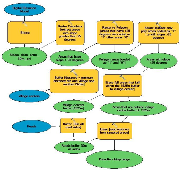
Figure 2. Model builder used for delineating areas for various use in developing village land use plans
2020 Scholar paper "The role of GIS in enhancing Land Use Plans that considers conservation objectives"
2020 Abstract: This paper aims to show the crucial role of GIS in guiding development of Land Use Plans that considers conservation goals of connectivity, watershed protection and refraining from cultivation on steep slopes to avoid soil erosion and landslides. The case study will be presented whereby GIS and Remote Sensing data were applied in guiding development of Village Land Use Plans that considers achieving connectivity of chimp habitat, protecting watershed, and influencing reserving areas with steep slopes to forest reserves to avoid soil erosion and landslides in villages around Gombe National Park.
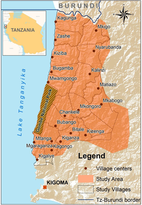
Figure 1. Case Study Area
The use of GIS and remote sensing data enhanced bringing existing situation on the table thus guides discussions when developing desired land use plans. GIS and Remote Sensing Data enhanced visualization of remaining relicts of forest patches that connects with Gombe National Park, watershed regions, areas of steep slopes thus aid guiding discussions of where to allocate forest reserves, watershed protection, grazing land, cultivated land and settlement areas.
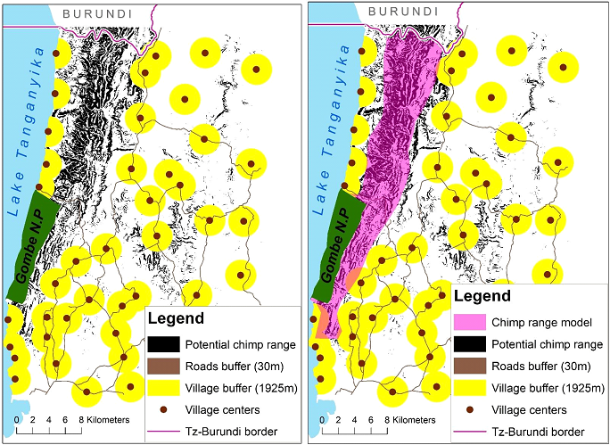
Figure 3. Model builder product outlining potential chimp range to be proposed for village forest reserves
The outcome was development of village land use plans that considers interconnection of village forest reserves (VFRs) that now act as buffer zone for Gombe National Park (GNP). The VFRs developed are (in total) almost three times larger than the size of GNP and now act as a corridor for connecting chimpanzees of GNP and those outside the park towards the boarder to Burundi.
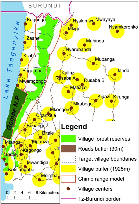
Figure 4. Connected Village forest reserves developed after the use of GIS and Remote Sensing in guiding development of Village Land use Plans
This achievement illustrates the power of GIS and Remote Sensing in guiding and influencing development of Land Use plans that considers conservation goals while empowering local community.
x2020 x2020Scholar x2020Talk xSpecies xEndangered xMammal xPrimate xCommunity xCitizenScience xPPP xEducation xLandscape xAfrica xTanzania, xData, xMonitoring xForest xRemote xPlan xData xModel xSurvey123 xAdvocacy xSustainableDevelopment xStorymap xArcGISOnline xPOC
- Mark as Read
- Mark as New
- Bookmark
- Permalink
- Report Inappropriate Content
Poa Poa. It's good to see such excellent uses of GIS in Tanzania.
-
 Anonymous User