- Home
- :
- All Communities
- :
- User Groups
- :
- Conservation GIS
- :
- Documents
- :
- Azalea Kamellia Abdullah, Malaysia
- Subscribe to RSS Feed
- Mark as New
- Mark as Read
- Bookmark
- Subscribe
- Printer Friendly Page
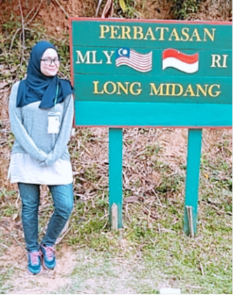
Azalea Kamellia Abdullah, Malaysia
Azalea Kamellia Abdullah, Malaysia
Azalea Kamellia Abdullah WWF-Malaysia (World Wildlife Fund for Nature)
7th Floor, Bangunan Binamas, Lot 138, Section 54, Jalan Padungan, 93100, Kuching, Sarawak; Malaysia
x2020 x2020Scholar x2020Talk xAsia xMalaysia xEducation xSustainable xAgriculture xCommunity xIndigenous xPlan xSurvey123 xStorymap xQuickCapture cCollector xEndangered xSpecies xBiodiversity xForest xCitizen xPlan xGeology xHydrology xModel xRemote xWildlife
2020 Profile
"In Malaysia, the GIS community is distributed rather widely with differing levels of understanding, which makes knowledge exchange challenging and time-consuming. Furthermore, most workshops and trainings are conducted by consultation companies or ‘experienced’ experts usually give a touch-base on what the tools can do but not the accounts of when it does not work. It is, without doubt, that to have someone to hold your hand throughout and tell where to click is a presposterous idea. Even so, a work is only effectively conveyed when it can be reproduced at least 70%. And to effectively apply it to another landscape and environment, it will take a longer time.
I have participated in Esri User Conference 2019 earlier this year and was blown away by the capacity of Esri’s products, the technical talks and workshops are very informative and I gathered as much information as I could to be able to implement it back in Malaysia, where I also participate as a GIS Support Analyst for Esri Malaysia
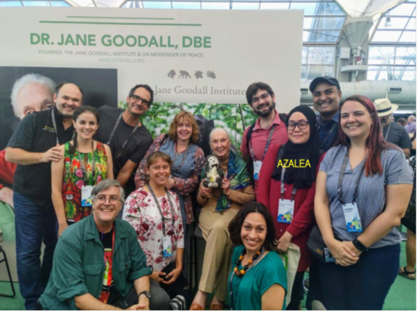
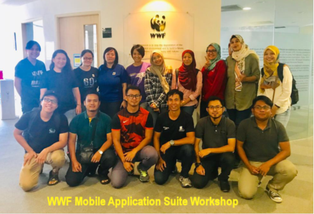
At this conference, I was surprised to learn that there is a society dedicated for conservation GIS where the members share ideas, tools and data source for their regional work. Courtesy to my WWF colleague and friend, Johanna Prussmann (Pictured Above, far right), I even had the pleasure to tag along and have fruitful discussion on the current analysis/technology during the course of the conference. It was so exciting to meet new people and hearing about their GIS ventures that I have gained a positive outlook and fresh perspective on my own work. Thus, I believe, to be more effective in my work and deliver actionable output, I have to be apart of this wonderful and engaging community.
Even so, after meeting with the SCGIS members during that time, I believe that I have lost the opportunity to optimize that time I had there to learn more and perhaps discuss more with fellow technicians in the conservation industry to address some technical issues I have been having with my own work. The Esri UC was wonderful and very informative, but the barrage of knowledge makes it hard kickstart my own tasks without significant time dedicated to trial and error. It is true that we land on our job, but if I could find and learn from someone else’s experience, I could be miles ahead with planning solutions instead of learning ways to troubleshoot.
I am grateful that at this age, the opportunity to acquire GIS knowledge is more accessible and readily available; something that I wished was there 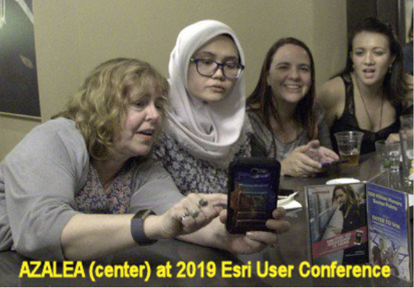 sooner. I learn about new tools and new information everyday from my time scouring the internet more information. But what I believe I can acquire in the SCGIS is the active learning that ensures my goals are really met. The immersion in the training and activities with that dedicated duration and environment, I believe, will transform my capacity as a GIS analyst. I’ll be able to focus, trod on to address my tasks effectively and in addition to that, I am able to make new comrades of the same field and receive continuous support from them as much as I am looking forward to provide mine for them.
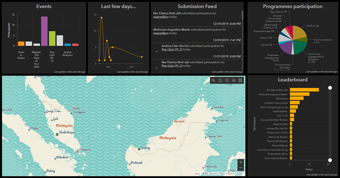
As mentioned above, I have participated in the Esri UC 2019 this year and learned about SCGIS, then later on helped organize the 2019 GIS Day for my country, creating the Operations Dashboard pictured below (https://arcg.is/1v8HPn). The 2020 Scholar Program will certainly help improve my ability to support and expand the programmes I am involved in. I intend to fully utilize the time to address my tasks in this training since it is the very same product I am eager to share with SCGIS members as well as my organizational colleagues.
WWF-Malaysia 2019 GIS Day Leaderboard (Operations Dashboard):
This Operations Dashboard gives the real time results and leaderboard of the events organized by CGIS WWF-Malaysia during the GIS Day 2019 celebration. In conjunction to the event, we have conducted a competition based on participation and winnings at each programs organized based on the publicized agenda.
WWF-Malaysia (World Wildlife Fund for Nature-Malaysia) is a known as the regional office of the larger WWF organization that was first established on January 13th 1972, dedicated to environmental conservation. In WWF-Malaysia, there are 4 known programmes that covers both landscape and three main regions in Malaysia; Peninsular Malaysia Terrestrial Conservation Programme (PMTC), Sarawak Conservation Programme (SCP), Sabah Terrestrial Conservation Programme (STCP) and Marine Conservation Programme (MCP), with 3 regional offices; Kuala Lumpur, Kuching and Kota Kinabalu. WWF-Malaysia works in priority landscapes that encompasses wildlife and ecological systems. The goal is to achieve long-term and sustainable conservation impact in the country by conserving, restoring, and protecting a diversity of species, forests, marine, coastal and freshwater environments. To enable the conservation work the cross-cutting activities; policy, environmental education and climate change, makes use of conservation spatial planning deployed by the GIS team. First recognized in 2015, the Conservation Geographical Information System (CGIS) team has been working to provide updated GIS and remote sensing solutions.
Under the different conservation programmes, WWF-Malaysia engages stakeholders in conservation efforts; local communities, concessions or goverment, to adopt or offer advise to assist in the development of the biologicaly enriched landscapes in Malaysia while protecting the unique species of flora and fauna. In a broad aspect within the country, notable or endangered species such as orangutan (Pygmy pymaeus), elephants and Malayan tigers are surveyed to gain observed population and to mark their areas of livelihood, its connection to the ecosystem and proximity to 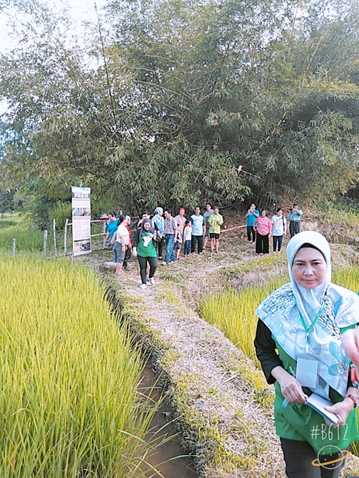 settlements/development plans to ensure that their existence are not being overlooked in the development plannings. Under SCP programme, forest cover is being monitored to ensure no illegal encroachment on protected areas. Oil palm plantation are being pushed for certification as well as advised to adopt best management practices; which includes the mandatory survey of high conservation value (HCV) elements. At a broader geographical landscape, wildlife corridors and continuity of habitat between Sarawak; Malaysia, and Kalimantan; Indonesia, enables the partnership between WWF-Malaysia and WWF-Indonesia for Green Economy project funded by the Germany Ministry of Agriculture. This effort also overlaps with the ‘Eyes on the Forest’ Project that monitors the concessions’ activities and licenses all over Sarawak – this project is funded by WWF-Japan.
I have been working with WWF-Malaysia for 2 years this coming April 2020. According to my job description, I am to provide support in any GIS needs required by the projects under the overarching conservation programme (SCP). There are 9 projects under SCP programme and I am in charge entirely of four; ‘Eyes on the Forest’ (EoF), ‘Sustainable Palm Oil’ (SPO), ‘Responsible Forestry’ (RF) and ‘Green Economy Project (IKI) and carries half the responsibility of one; Conservation Spatial Planning. The ultimatum role in my post is to provide the latest landcover map to outline the vegetation cover across Sarawak. Other work are as mentioned below, outlined in accordance to the projects:
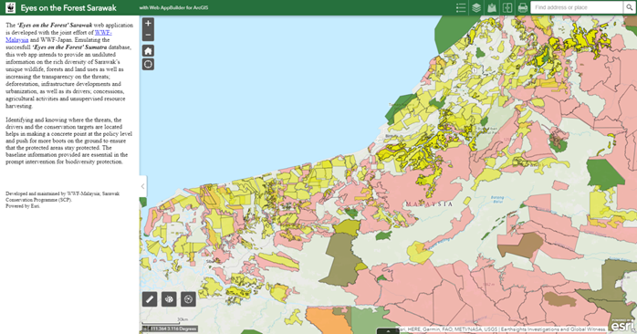
For ‘Eyes on the Forest’ (EoF) project (photo below), it was required that WWF-Malaysia (SCP) to develop a website that contains all the relevant data for logging activities monitoring; which includes the information on license planted forest, oil palm plantation, total protected areas, timber licenses and monitoring template for real-time field observation. First sent out to find out the content of the hub portal at the Sumatran region that we were advised to replicate, I managed to propose the usage of ArcGIS Online web application instead to save any consultation costs to replicate the same type of hub as the ‘Eyes on the Forest Sumatra’; developed with the help of Google Outreach Programme. This also nullifies the possibility of encountering bureaucracy when troubleshooting for technical disparities in the output and increasing the advantage of exploring and applying the ways to optimize the data usage or visualization. This web app has been used as a blueprint to propose the plan to utilize customized web app for each projects to have to be able to visualize, analyze, edit and update their own data. The inclusion of oil palm plantation license data and ‘Environmental Impact Assessment’ (EIA) reports in this (EoF) web app manages to meet the requirement of systematic organization and visualization of the oil palm plantation and concession in Sarawak required of SPO project. My hope is to amp up the game with this web app and couple it together with Operations Dashboard and make it a user-friendly app for quick and effective reference any project officers can refer to. (https://arcg.is/15XnXH)
Eyes on the Forest Sarawak (Web Application):
'Eyes on the Forest ' web app initiative records the biodiversity richness within the Sarawak region and monitors the potential risk of deforestation due to land development and resource harvesting.
For ‘Responsible Forestry’ (RF), I am tasked to create the database of high-conservation value elements and to keep them updated for references to local community should they require assistance from WWF-Malaysia to validate HCVs mapped and outlined by concession working in close proximity to their settlement/native land.
I am responsible to put together the data for the output of a landuse map and contribute to the technical document that outlines the development, economical and urbanization aspects within the IKI project area along with the conservation targets; orangutan species and forest of total protected area. Other than this, the transboundary elements between Sarawak and Kalimantan are also compared and grouped together to outline the ‘continuity’ of the IKI project.
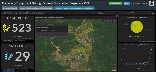
(Above Screenshot of ‘Community Engagement Strategy’ operations dashboard. It contains all the monitoring work being done by the Community Engagement strategy including the community mapping and SRI paddy plots)
Community Engagement Strategy (Story Map) (Map Series format) to summary and document the work executed by the Community Engagement strategy Developer: Azalea Kamellia (Data source: McKenzie Martin)
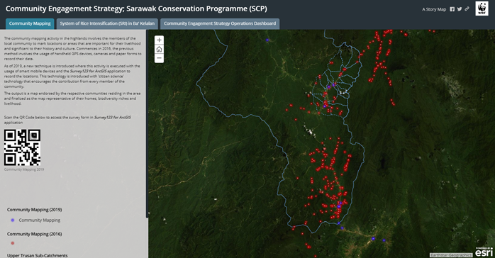
(From Storymap Narrative: "The community mapping activity in the highlands involves the members of the local community to mark locations or areas that are important for their livelihood and significant to their history and culture. Commences in 2016, the previous method involves the usage of handheld GPS devices, cameras and paper forms to record their data.
As of 2019, a new technique is introduced where this activity is executed with the usage of smart mobile devices and the Survey123 for ArcGIS application to record the locations. This technology is introduced with 'citizen science' technology that encourages the contribution from every member of the community.")
A personal achievement that I am believe is a real success is the socialization of the Field Operations app bundle under Esri. A workshop on this has been successfully conducted for the non-GIS officers and field officers from the different programmes across the regions and more of them are starting to effectively utilize Survey123 for ArcGIS as an effective tool for data collection. Although this app is not new within WWF-Malaysia, not all programmes and projects are appropriately taught of its usage, functions and technicalities. In successfully conducting this workshop, I have managed to also reintroduce GLOBIL, outline the usage of Collector for ArcGIS and also generate a standard of procedure (SOP) for this GIS solutions. Currently, we are attempting to utilize QuickCapture and implementing Survey123 offline for community mapping at the highland region of Sarawak. Our hope is that this app could fill in the gap that cripples the ‘data transfer’ between data collectors and GIS analysts and strike off the usage of paper forms.
All of the work mentioned above are of the tasks that I have managed to execute within the WWF-Malaysia office. In addition to the work there, I am also apart of the COMPASS hub created within the WWF network that gathers together spatial analysts and experts. In this community, I am currently developing the web app to substitute as the database of the experts within WWF organization globally. The purpose is to develope a validated hub of expertise and to enable the contact between the inquirer and the expert for knowledge exchange and socializing work among the organization.
What is your history of work in conservation and GIS? I have no significant work within the conservation industry in my previous professional work but my educational background and personal upbringing encourages simple living and minimalism; take what you need and avoid extremities. Although I am involved in environmental studies; studied geology in university, and was attached to a tropical peat research laboratory, I was more involved in the execution of petrographic/geochemical/checmical analysis rather than the data analysis.
For 2 years (2014 – 2016), I was a graduate studies candidate doing research on the mobilization of of micronutrients in the tropical hydrogeology. Despite not being able to conclude the study, I managed to model the possible hydrochemical mobilization using GIS by plotting the micronutrients concentrations, water table of the different sampling sites and the surrounding elevation. It was my first encounter of a dedicated usage of GIS.
The next 1.5 years was spent working as a technical support analyst for the Internation Support Center Esri in Kuala Lumpur. This is when I became more exposed to the usage of GIS in conservation and environmental studies. I learned alot in this short duration and most of what I learned from assisting domestic users with the technical aspect of the software is the way spatial analysis, earth imagery and mobile application are utilized in a synchronized system to monitor the changes in the environment and predict the possible outcomes of any developmental or urbanization planning that overlaps with intact rainforest ecosystem in Sarawak.
From there, I am enthusiastic in creating a dashboard of comprehensive data, visualized adequately for users, with updated information and real numbers that could assist decision-makings or help them influence stakeholder in a conservation landscape to understand the degree of their anthropocentric intervention in nature. The ‘Eyes on the Forest’ web application is a preliminary output of the work put together that requires further customization.
For the purpose of ground data collection, I am implementing citizen science for community mapping at the Sarawak highlands where the local community in differing settlements collect the location data of the places of cultural, heritage and livelihood importance to them. This project helps them to ensure that concessions in the nearby proximity are aware of the boundary between the settlement and marks the resources crucial for their livelihood.
Personally, I also intend to be more involved in green initiatives in city I live in and will be deploying a survey form that employs assistance from the public to mark the areas where recycling bins/centers/pit spots or establishments that accepts recyclables are located within Kuching. Green living and steps to achieve it is still a work in progress in developing countries such as ours and engaging the public especially in this era of technology is crucial to give them the sense of belonging; something that citizen science could initiate.
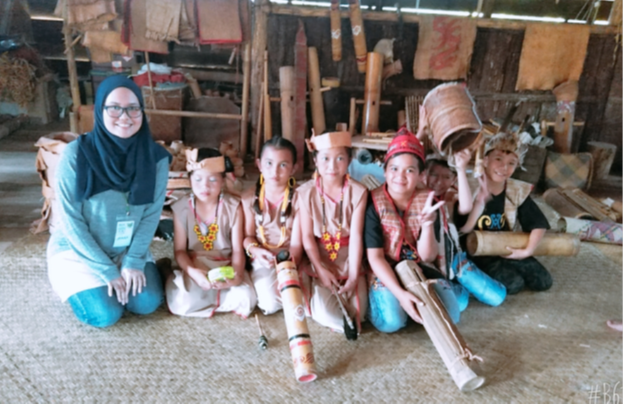
(Photos: e-Borneo Knowledge Fair October 2019 at Ba’Kelalan situated at the Northern highland of Sarawak. Presented abstract ‘Citizen Science Mapping Using Synchronized Mobile Application Suite’.)
Please describe your experience in teaching: I have conducted GIS training in a workshop that consist of lectures and practical; to ensure effective learning, as well as webinars. Some of the workshops conducted are mobile application suite usage for data collection for non-GIS users withing the organization as well as for the local community of the conservation area project sites. The size of these workshop ranges from 15 to 30 people at a time.
I am also familiar with assisting and guiding individuals with technicalities as well as knowledge-based information from my experience as technical support analyst as well as freelance editor/proof reader.
What is the most unique and the most challenging about the conservation/GIS work that you do? In WWF-Malaysia, the challenge can be viewed as internal and external. Internally, GIS is basically seen as a branch of IT to which, we have the ‘toys’ that not everybody knows how to use and duped similar to any softwares installed in computers. There is a mistaken belief that a GIS person will know how to reformat the computer they use - which is not entirely incorrect but inaccurate nonetheless. The knowledge on GIS, the trends are pretty much intermittent among non-GIS users; they are interested in keeping up with advanced technology in the spatial data science industry but do not have the patience to grasp the understanding of how it works nor trying it out with the GIS team using the existing resource available. More often than not, external consultants are employed and most of the time, we are only brought in to verify output that are not at par with the standards we would expect. Since my involvement with the organization, I have been trying to implement that fool-proof usage of the tools that are already readily available with the tools that we already have; ArcGIS Online and ArcGIS Pro. Schedules of officers that are unexpected causes me to also opt for webinars; live, or record the session for their reference. Although most of them admit that it is not the most effective but persistence may make a dent and my hope is that they are keen enough to upgrade their conservation work and try out some of the solutions we share.
Other than that, despite having remote sensing specialists in the team, most of them are not attached to the SCP programme specifically and requesting for assistance in tasks that involves this aspect of spatial data science is slow-moving since they are employed under another conservation programmes which makes collaboration time-consuming. This is the kind of issue that we also have due to differing experience and backgrounds in GIS; not only in terms of level or years of experience, but also backgrounds. Other than diversity, time has to be dedicated to come up with a solution that everyone can agree and independently pursue. The only way to get the most even out of these experts seem to be laying out your own understanding first and suggest the first step to enable my own comprehension of their knowledge. I believe in asking questions and a discussion that has no questions raised has polar outcomes; either they understand you so well that no further explanation needed or the fact that they cannot understand you and have no interested to be involved.
Working with local communities may require the assistance of project officers who are experienced in communicating with them. Preliminary investigation of their levels of understanding, tehcnological savviness as well literacy plays a role in making them understand the maps that has been generated as well as the tools we would like for them to try.
Current GIS Interests? I have been learning GIS on my own aside from coding from online researches and being a part of online communities in social media; dev.to, Cartographer’s Guild, MapScaping. Since I work mostly with Esri’s products, GeoNet as well as ArcGIS Learn and technical articles are my major reference. Most courses and workshops that I participate in is online since it is the most economical. In addition to that, I refer to published books and papers.
Analysis I had the opportunity to verify the methodology of identifying the best location to install camera traps for the Malayan tiger as requested by a colleague utilizing the overlay analysis. I have participated in a MOOC and found out that overlay analysis procedure seems to be the core of suitability modeling
I am especially interested in fully utilizing Spatial Analyst capabilities in ArcGIS Pro to make the most of analyzing image classification for land covers and hydrology. Our conservation programme in Sarawak is big on monitoring the changes in the forest cover and also vegetation classification which are quite advance techniques involving remote sensing techniques in satellite imagery – Landsat 8 and Sentinel-2; something I am familiar with but have little to none experience in executing it effectively. Recently, we have been asked to jump into the wagon with the usage of radar satellite imagery SAR to optimize the resource we could use to monitor land cover changes which makes it hard for our team of 2 people who has very basic skills in remote sensing.
Enterprise GIS Working with the GIS team, I am responsible in establishing the data naming convention, standardization and socializing the metadata tasks to other colleagues in the organization.
We work together with the IT team to establish a replication of our existing global ArcGIS website (AGOL); Global Observation and Biodiversity Information Portal (GLOBIL). Each three regional GIS Team is to outline the schematics of how their data is arranged and accessed by their respective offices. So far, we have only managed to executed data standardization and waiting to install ArcGIS Enterprise into the new server infrastructure soon
Web mapping I am currently working on developing the web application for a project called ‘Eyes on the Forest’ that monitors the concession activities across the Sarawak region as well as a hub to compile relevant data that could enable easy viewing, analysis and updates. Since enrichment of the web application requires the usage of APIs, I have been working on implementing some scripting; with mediocre success, into the web application.
So far, I have only been able to customize scripts to build the web application and customize symbols but is not able to implement it into the web mapping for the lack of understanding on the technicalities.
I also intend to implement a real-time update of landcover changes analysis based on the satellite imagery in web mapping applications which I heard is possible in ArcGIS Developer using machine learning techniques. Just displaying the data and make it easier for non-GIS colleagues to view or edit them is not enough. We would like for them to be able to have simple analysis; clustering, hotspot analysis etc., and have wider range of capabilities to create a printable map of their own for presentations or stakeholder meetings. The web applications that we manage to develope are barely scratching the surface of web application capabilities that I so often see being shared by ArcGIS Developer in social media. I am happy that they provide the tutorials but I have no means of knowing how to get it into our own project due to lacking in IT knowledge like what is Microsoft Server...where do I place the codes so that it will show in the web app...Knowing how to do it is good but we want to be able to really get it into the object itself which we are still in the dark with.
Field operations In-depth knowledge of developing field data collection data model and configurations to enable real-time data collection and offline data collection – ample understanding of the ArcGIS Online environment.
I am able to create and customize Survey123 forms without issues and maximize its usage which includes the bare minimal scripting and combining it with Collector for ArcGIS. Currently gaining great interest in adopting QuickCapture for more security-sensitive expeditions on field by field officers.
ModelBuilder and Python Additionally, I would also like to understand the usage of ModelBuilder and Python more to upscale our productivity in environmental analysis and database management. With the increase in centralized database capacity (infrastructure and deployed software), we are finding it more crucial to implement the usage of Python to cut down the time required for us to do menial work in GIS; converting the format or projections of large number of vectors, renaming them etc. I am able to deploy open Python console but still can’t seem to get it right when it comes to running the code despite many attempts to follow the various way to run them via resources I have referred to. If Modelbuilder and Python can make our work more effective and let us focus more on analyzing and implementing methodologies, I believe that I can no longer pretend I can point and click my way to quicker task completion or competent output.
Title of your 2020 Paper: ‘Eyes on the Forest: Sarawak’s Landscape Online Database’ (see photo above)
2020 Abstract: To address the redundancy and highly diluted information on Sarawak’s forests, wildlife and climate variables, the ‘Eyes on the Forest’ web application is developed with the joint effort of WWF-Malaysia and WWF-Japan. Emulating the succesfull ‘Eyes on the Forest’ Sumatra database, this web app intends to provide an undiluted information on the rich diversity of Sarawak’s unique wildlife, forests and landuses as well as increasing the transparency on the threats; deforestation, infrastructure developments and urbanization, as well as its drivers; concessions, agricultural activities and unsupervised resource harvesting. Identifying and knowing where the threats, the drivers and the conservation targets are located helps in making a cocrete point at the policy level and push for more boots on the ground to ensure that the protected areas stay protected. Furthermore, accessibility to a verified and updated database will also assist goverment bodies to plan a more structured and ‘green’ infrastructure development.
The ‘Eyes on the Forest: Sarawak’s Landscape Online Database’ is a culmination of the ground work that has been done in Sarawak to compile the information on forests, wildlife, native settlements, landuses, land change and development stakeholders. In addition to better assist WWF-Malaysia Sarawak Conservation Programme officers to store, update, visualize and analyze their data, it is also intended to be made accessible to the public. It compiles the rich biodiversity and habitats as well as their changes in relation to development of the years. As the Sarawak Landuse Masterplan by the Sarawak State Goverment begins to take shape by 2020, a platform that provides real-time, undiluted and comprehensive stocktake on Sarawak’s biological assets become of an urgent need.
We are conscious of the changing demography as well as economy in our state and are committed in providing the transparent information to meet the emerging need for green infrastructure in state planning. For this purpose, we are planning to include the real-time monitoring of deforestation extent on weekly basis utilizing the machine learning for deforestation detection from satellite images. This feature will assist in detecting illegal logging or protected areas encroachments. This visual info on the threats compromising the protected areas as well as its drivers; which will better assist the deployment of field officers from the newly appointed agency entrusted to execute their work on the ground. We believe this project will make a huge difference in conservation planning as well as policy enforcement of the state of Sarawak.
To be able to develop this online database optimally, I am eager to participate in the SCGIS Scholarship Programe 2020 to learn more on adding in the functionalities as well exchanging ideas with fellow conservation colleagues who has more experience. Being an SCGIS member has already given me amenities to work on my small personal project for green initiative, and I believe the Scholar program will be able to assist me more in developing the online database that could assist many stakeholders and agencies at home.
-
 Anonymous User