Alexandru Ciutea, Romania
- Subscribe to RSS Feed
- Mark as New
- Mark as Read
- Bookmark
- Subscribe
- Printer Friendly Page
- Report Inappropriate Content
Navigation: 2018 Scholar Project ReferenceProject CommunitiesPage ConservationGIS Scgis.org
Alexandru Ciutea, GIS collaborator, Greenpeace Romania
xForest xAdvocacy xChapter xRomania x2018Scholar x2018Talk xInterview2018 xScholar xTalk xeurope
 <-pdf
<-pdf  2018 SCGIS Conference Presentation mp4->
“ Primary Forests Potential Map of Romania”
"The largest areas of old-growth, or virgin forests from the temperate region of the European Union can be found in the Carpathian Mountains of Romania A lot of these forests are endangered by logging activities, which are intensifying. "

 <- 2018 Interview on the first time he learned about SCGIS and his origins working in conservation & mapping
2018 Scholarship Program Storymap -->
on the Primary Forest Potential Map of Romania
Alexandru Ciutea, GIS collaborator, Greenpeace Romania
 Calea Șerban Vodă, no. 176, Sector 4, Bucharest, Romania Alex says Hello & Thanks to SCGIS
*-Main email: info.romania@greenpeace.org
http://www.greenpeace.org/romania/ro/
Skype etc:Skype: Alex Ciutea email: aciutea@greenpeace.org
*-ORGANIZATION’S WORK: Greenpeace Romania was established ten years ago, in 2007. Currently we are conducting two campaigns, one related to energy and climate change and another one about forest protection. In the past years we were also working on campaigns related to nuclear energy, sustainable agriculture, shale gas or gold mining.
The forest campaign is focused on two main topics: primary (or old-growth) forests and illegal loggings investigation. Romania has the largest areas of old-growth forests in the temperate region of the European Union. Because in Romania currently there is no comprehensive inventory, we are working on the mapping of the remaining old-growth forests. An important step in this direction is the “Primary Forests Potential Map of Romania” project. After this preliminary mapping, that was done using GIS and remote sensing techniques, the aim will be to officially recognize these forests by validating them in the field, and put them under strict protection. On this note, we talked with the Romanian ministry of the environment and they agreed to use our map and do the field validation of the forests. The validated forests will be included in the official national inventory and will be strictly protected. Because of much wider resources, the Romanian authorities have the best capability of field-validating old-growth forests, but with the help of experts, Greenpeace also does it. This was the case in 2016, when we field-mapped three ancient forests within a project called “Romanian Forest Rescue station”.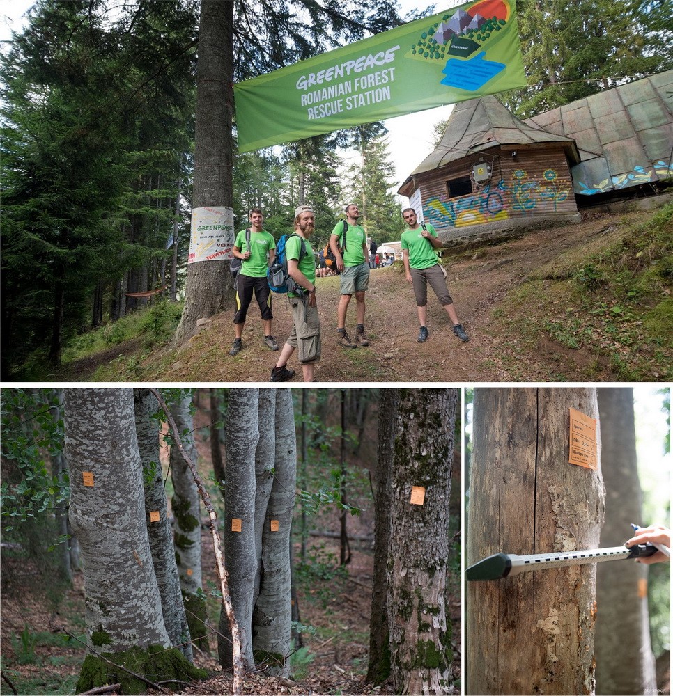
Another important project regarding primary forests was the Romanian Forest Rescue Station, which took place in 2016. The goal was to map three ancient forests situated near Vidraru Lake, in the Carpathian Mountains. Greenpeace volunteers from all around Europe helped in the field validation of the forests. After the field survey, we submitted the study to the Romanian authorities for the purpose of including the charted forests in the official national inventory.
The other part of the forest campaign consists on reducing the amount of illegal logging. A good example of our work in this direction is the implementation of an online platform (salvezpadurea.ro) where anyone can report an illegal logging, considering some known indicators.
Greenpeace is also known for using nonviolent direct action to raise the awareness about a certain topic or to actually stop an ongoing activity. In 2017 we did actions related both to the forest and energy campaign.
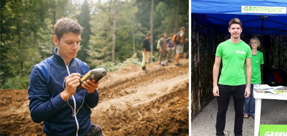
*-ROLE IN THE ORGANIZATION: I began working for Greenpeace in August 2016, as a volunteer for the Romanian Forest Rescue Station. The aim was to map three ancient forests situated in the Carpathian Mountains of Romania. I was part of a small, multinational GIS team that was responsible for preparing and coordinating the field trips, organizing and analyzing the collected data. Personally, I was in charge of preparing the maps for the field trips and also coordinate the team responsible for the plot establishment (because the area of the forests is large, we established some plots to be analyzed in the field). After the field surveys, I was responsible for creating the final maps that were attached to the study that was submitted to the authorities. I was also responsible for the documentation and mapping of the forest destruction, being able to create a map showing the extensive logging of the old-growth forests in the area.
Between February and September 2017, I coordinated the “Primary Forests Potential Map of Romania” project, also being one of the two authors of the study. The purpose of the map is to identify the last remaining old-growth forests in Romania using remote sensing and GIS techniques. We called it a “potential map” because primary 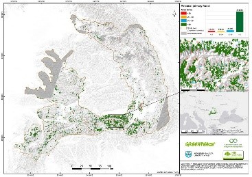 forests can be precisely identified only in the field studies, but an estimation of their location and extent can be done using remote sensing and GIS techniques. I was also responsible for processing and analyzing the satellite images (the so called remote sensing part of the study). The study was conducted in collaboration with specialists from Eberswalde University (Germany), which helped with the filtering and analysis of the polygons resulted from the satellite image analysis. We identified almost 300.000 hectares of potential primary forest. You can visualize the complete study and the methodology here. After the official launch of the map we talked with the Romanian ministry of environment and they were willing to use our map and do the field validation of the forests.
 Beside these projects, I am involved in the illegal logging investigation unit of Greenpeace Romania. Using satellite images and the available information provided by the authorities, I am monitoring forest logging and searching for illegal activities. I am also involved in a project called “Forest Guardians”, which will be implemented in 2018 and exploits the idea of participatory mapping. Basically, we designed a smartphone app where any user can help in identifying forest loggings comparing multiple sets of high resolution satellite images.
*-HISTORY: My first contact with GIS was during my bachelor's degree, while being a geography student. During my studies, I was involved in some projects and organizations related to GIS. For example, I was involved in a project with the purpose of creating a digital database of all the rivers in Romania, on a 1:25,000 scale. My role, beside the actual GIS work, was to teach younger students some GIS techniques, like digitizing, in order for them to being able to help with the project. Basically, my work related with both conservation and GIS began with my involvement in Greenpeace.
*-Current GIS expertise:
In 2016 I finished my masters in Geomatics, where I learned a lot about GIS and remote sensing. I have recently published an article based on my master thesis which you can visualize here (http://www.primanatura.ro/en/utilizarea-imaginilor-satelitare-sentinel-2-in-identificarea-padurilor-...). In this article I described an algorithm which proposes an automated method for the identification of old-growth forests, on a smaller scale (a small mountain range in Romania). For this project I used mainly ArcGIS Desktop, but also other software like Global Mapper, SNAP and SEN2COR (for Sentinel 2 satellite images processing).
The above mentioned research was the starting point of another study called “Potential primary forest map of Romania”, conducted this year by Greenpeace Romania. I was the coordinator of the project and one of the two authors of the study. This project was a real opportunity to improve my GIS and remote sensing skills. I learned a lot about object based classifications and satellite image processing and analyzing. You can visualize the complete study and methodologyhere. We choose to use a semi-automatic algorithm (a fully automatic one being very hard to implement) which combined methods like object based classification and visual interpretation of multispectral satellite images (Sentinel 2). I used softwares like eCognition Developer for the object-based analysis and ArcGIS Desktop for data filtering and map creation.
Coordinating the GIS team working on the “Primary Forest Potential Map of Romania” project was one of the most challenging and inspiring experiences. I worked with volunteers from Romania, but also from Germany. Aside the actual GIS work, I had to travel to Germany to establish an official collaboration with Eberswalde University. There, among many great people, I met with Pierre Ibisch, Professor for Nature Conservation, which kindly offered his support.
In 2016 I was a volunteer in a project called Romanian Forest Rescue Station, being part pf the GIS team. I did a lot of office work but also a lot of field work, using Topcon GPS devices and working a lot with ArcPad. I will give more details about the camp and my work there in the following sections.
Currently I am a PhD student and also I work with Greenpeace Romania as a GIS collaborator. I learned a lot of GIS in the university, during my masters and I am doing GIS related research during my PhD. Most of this research is also related to Greenpeace.
Greenpeace had a major contribution in improving my GIS skills. For example, in December 2017, I participated in an international Mapping skillshare, which took place in Netherlands and was organized by Greenpeace. There we had the chance to present and discuss technical aspects of our work and share GIS knowledge and skills. Also, we wanted to promote and to emphasize the importance of using GIS in Greenpeace projects.
In October 2017 I participated in the SCGIS Russia conference in Sankt Petersburg. There I had the opportunity to learn a lot of things related to GIS, by participating in workshops and sessions and also by meeting with many passionate GIS enthusiasts. I had the opportunity to present our work related to the primary forests potential map, share the methodology and receive useful feedback. I stayed in Russia only for three days, but in that time I had the opportunity to meet with many passionate GIS people, working on very interesting projects and also participate in some truly inspiring workshops.
In December 2017 I participated in an international mapping skillshare, organized by Greenpeace International. I had the opportunity to meet my colleagues from all around the globe and share knowledge. There I ran a workshop, presenting some sources of satellite imagery that could be used in investigations.
Currently I am leading a small, but very passionate, GIS team of Greenpeace volunteers. Together we are doing the GIS work in Greenpeace Romania.
I think the most effective way to learn and to improve your GIS skills is by participating in such events and be part of communities like SCGIS. I could take as reference the SCGIS conference in Russia or the mapping skillshare in Netherlands, for example. There, in a few days, I can say I learned a huge amount of things related to GIS and I meet many wonderful and passionate people. Not only that these meetings changed my life, but also I think they were really important for the future of GIS and eventually for the protection of the environment in Romania. I could only imagine the things I would learn, the people I would meet during a few weeks of trainings and conferences in California.
What is the most unique and the most challenging about the conservation/GIS work that you do?

Greenpeace is known for using nonviolent direct action, so besides working with GIS and doing research, I am also a Greenpeace activist. Sometimes these two roles are intertwining in a very harmonious way. That being said, in some cases I found myself going on an action as a result of my GIS research I have previously done. The best example is an action that took place in August 2017, when we stopped an illegal logging that was destroying a primary forest. Using Sentinel 2 satellite images, I have been monitoring some primary forests and searching for signs of logging. Fortunately, the temporal resolution of Sentinel 2 satellites is good enough for doing useful change detection analysis. Therefore, in August 2017 I spotted an unusual change in the canopy of a forest I have been monitoring. This turned up to be an actual illegal logging. We decided to put an end to it before it is too late and the forest would have been destroyed completely. On that note, we actually went into the forest and stopped the logging as it was taking place. Leaving my office chair for taking part in direct actions is by far the most unique part of my work. It is a real motivation knowing that the GIS work we are doing is sometimes materializing in direct actions.
*-What do you hope to achieve in your conservation GIS work over the next year?
For Greenpeace Romania, 2017 was a turning point when it comes of using GIS in the organization. This was the first year when the organization decided to really make use of GIS and start a serious GIS project, like the “Potential Primary Forests Map of Romania”. The new GIS capabilities were very useful in the investigations as well. Of course that, over the next years, we want to extend the GIS capabilities in our office. We would like to continue the work we started in 2017, but also we want to begin new projects:
- We plan to continue the work on the primary forest map and improve it. We were also planning of developing an algorithm for old-growth forest identification that would be easy to implement on wider areas and different regions of the globe, with more accurate results. The protection of the old-growth forests is of serious concern not only in Romania, but also for the entire Europe. Currently, conservationists in Europe are working on a strategy regarding the protection of old-growth forests (more details here). Old-growth forests cannot be protected if we do not know their location, so their identification is a very important step. In June 2017 I participated in the European Beech Forest Network Workshop in Germany, where we discussed the old-growth forest strategy. There, I presented the Potential Primary Forests Map of Romania, which was considered a very important step for the future of the protection of the old-growth forests across Europe. We agreed that an algorithm for the old-growth forest identification for all Europe should be developed. Thus, the existing algorithm can be improved, but this is very challenging task and I am hoping that the participation in the SCGIS conferences and trainings will be of real benefit for the protection of the old-growth forests in Europe.
- Another important project that we started in 2017 is called “Forest Guardians”. Using a smartphone app with a good looking user interface and high resolution satellite images we plan to involve everyone into the monitoring of the forests using remote sensing techniques. The app will be launched in March 2018 and will be based on the idea of participatory mapping. This is a still in development project and if it all goes well we plan to extend the capabilities of the app and the monitored area. For this app we are using very high resolution, on demand, satellite images, which are expensive. On that note, I would like to explore cheaper alternatives, like drones or other remote sensing platforms. I would really like to raise this subject in the SCGIS community and discuss about how we could practically implement these alternatives.
- A similar, but independent project for 2018, will be the implementation of an online platform with basically the same purpose, namely illegal logging activities detection using remote sensing data, but on a much wider area. In addition, besides using free remote sensing data for logging detection, this platform will also provide much more information, like wood transport and logging authorizations. A similar platform, designed by the Romanian authorities already existed, but it was recently shut down with no perspectives of recovery.
- A very important objective for 2018 will be the increasing of the international collaboration, including the collaboration between Greenpeace GIS units worldwide. An important step in this direction was the mapping skillshare we had in December, in Netherlands. There we build the bases of a global community of Greenpeace mappers, called Global Mapping Hub. This was a very important meeting for the future of GIS in Greenpeace Romania, because the increasing international collaboration will have a positive impact on our national projects as well. Also, on my turn, I can get involved and share my experience in other campaigns and GIS projects around the world. Therefore, I think that being involved in the SCGIS community will be very beneficial for Global Mapping Hub also.
For me it would be life changing to be part of the SCGIS community, as a member or as a volunteer. As I said before, participating in the SCGIS Russia conference was one of the best experiences of my life. This experience gave me the motivation and the willingness to be more connected to the SCGIS community in my region. And I can say I was really excited to see that Romania’s southern neighbor, Bulgaria, has a SCGIS chapter and that they kindly offered their support and cooperation. My first contact with SCGIS Bulgaria was done through Prof. Dr. Stefan Stamenov and I can say it was a really warm welcome and I hope, the start of a new and fruitful collaboration.
2018 Paper Title & Abstract: Primary Forests Potential Map of Romania
The largest areas of old-growth, or virgin forests from the temperate region of the European Union can be found in the Carpathian Mountains of Romania (Jan Knorn et al., 2012). A lot of these forests are endangered by logging activities, which are intensifying. Cataloging a forest as virgin or quasi-virgin can only be done in the field studies, however an estimation of the location and extent of these forests can be done using GIS and remote sensing techniques. This kind of estimation could be very useful when planning the future field studies.
It is very possible that the methodology and thus the map will be improved until June 2018, but the topic remains the same.
You must be a registered user to add a comment. If you've already registered, sign in. Otherwise, register and sign in.