Community Development Blog

cancel
Showing results for 
Show  only  | Search instead for 
Did you mean: 

Other Boards in This Place

Latest Activity

(8 Posts)
ShannonMcElvaney
Occasional Contributor

Inspiration

The Geodesign Summit is meant to inspire. Each year we hunt for presentations and organize couch talks (our form of panel discussions) to ignite interesting conversations that stimulate the grey cells and inspire attendees to try new technology to come up with innovative solutions.

24595435659_2a0b1ae93b_z.jpg

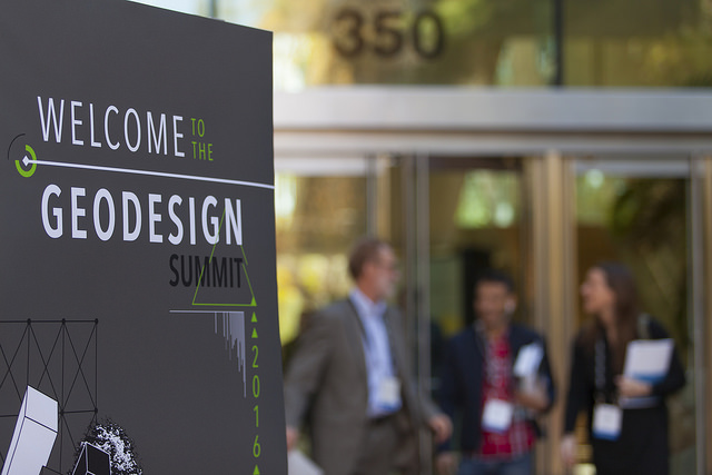
Each year, the Geodesign Summit is held at the Esri Headquarters in Redlands, California.

As an organizer, one of the things that inspires me are the reactions we get from attendees. There is an obvious need for spatial planning both in the government and private sectors, and universities like the University of Florida (UF) are stepping up to meet that demand by offering geodesign courses and degree programs.

Perspiration

Creating new curricula and introducing new degree programs at major universities is challenging. It takes a champion and a lot of perspiration! And Paul Zwick, professor at UF knows a lot about working hard to get things done.

Paul and his colleagues took it upon themselves to develop a Geodesign Specialty​ at UF, available this Fall to anyone pursuing the popular Sustainabilty and the Built Environment major in the College of Design, Construction, and Planning. And there are few professors more qualified than Paul and his colleagues to take geodesign principals and put them into practice.

Experience

UF has been doing geodesign for over 20 years. The publication of Smart Land-Use Analysis: The LUCIS Model (2007), written by Paul Zwick and Margaret Carr, was one of the first publications to lay out a geodesign process for land use planning. The recent publication Advanced Land-Use Analysis for Regional Geodesign: Using LUCISplus, co-authored again by Paul Zwick, revamps the original and cements UF's reputation as a center for geodesign.

24332221264_5ba92c6ed4_z.jpg
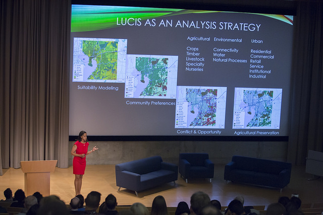
Iris Patten, co-author of Advanced Land-Use Analysis for Regional Geodesign book, presents 

LUCIS Plus as a spatial planning tool for evaluating areas of potential conflict and opportunity.

UF also has the GeoPlan Center, a self funded GIS consulting program focused on  land use, transportation, and environmental planning in the State of Florida. They host tons of GIS data for the entire State of Florida and assist many communities in their planning efforts.

The Geodesign Advantage

Since 2010, interest from students, teachers, and universities has continued to grow, and with each year we see more universities starting geodesign programs in the US and around the world.

Is getting a geodesign degree or emphasis practical? I'd say yes. I've talked with many employers, from Jacobs Engineering to HDR to Stantec, who are looking for graduates with geodesign skills they can apply to community planning.

So if you like GIS, but are undecided, take advantage of the opportunity at UF and add it as a geodesign specialty to your sustainability major. You have great, dedicated professors, who've published geodesign books and created geodesign tools, and you'll have ample opportunity to practice doing geodesign on real world projects.

Plan this right, and you can build your resume while getting your degree! Oh, and did I mention it's in Florida?

(The next Geodesign Summit is scheduled for January 25-26, 2017 in lovely Redlands, California at the Esri Headquarters, 380 New York St. Mark your calendars now!)

more
0 0 2,107
ShannonMcElvaney
Occasional Contributor

The Trust for Public Land Senior GIS Web Manager Opportunity

I just had to post this as a blog piece, because it is rare when a job like this comes up. I've admired TPL for years. They are responsible for establishing parks and open space in states across the country! And if you haven't been watching what they do with GIS to help make that happen, then you should check out these sites. TPS's ParkScore​ makes headlines every year when they publish their big city park rankings. Nothing like a little peer pressure to energize communities to create more parks! And then there is ParkEvaluator​ to help park managers create alternative plans for park placement driven by performance metrics. They have probably helped establish a park near you. They built a nice web map to help you explore their work.

If you'd like to help them continue this great work, TPL is looking for a person who has the following:

1) a passion about the power of GIS and internet mapping

2) a desire to work for conservation organization who's mission is to make a difference through a “land for people” mission

3) strong knowledge of Web/GIS technology and a talent for creating great looking web apps

4) strong project management skills and a love to keep up with new directions in the field

5) and great teamwork skills

If you are interested in helping TPL with creating and protecting great places for people that also protect the environment, check out the job description here: http://www.tpl.org/about/jobs/sr-gis-web-manager[tpl.org]

Happy web mapping.

more
0 0 887
ShannonMcElvaney
Occasional Contributor

The 3rd Annual Fall Geodesign Forum at Philadelphia University examines enabling technology (especially 3D) which helps us to better understand, plan and design sustainable communities using geodesign methods and technologies. We can do a much better job of defining what we care about, and then creating designs that can meet those goals. This forum is about discovering what you can do to design a better future.

Keynote

This year’s Keynote Speaker will be Tom Fisher, Director of the Metropolitan Design Center and the Dayton Hudson Chair in Urban Design at the University of Minnesota. This year’s Keynote Speaker will be Tom Fisher, Director of the Metropolitan Design Center and the Dayton Hudson Chair in Urban Design at the University of Minnesota.

Presentations by leading practitioners and thought leaders include:

-Geodesign Technology in the Workplace – Elliot Hartley, Garsdale Design, Ltd., UK

-3D Visualization for Urban Planning and Design – Eric Brady, Bergmann Associates, Rochester, NY

-Ground-Based LiDAR Workflow for GIS and BIM 3D Modeling" - Patrick Gahagan, Esri and PhilaU and Daniel Rich, PhilaU Geodesign '15

http://bit.ly/PhilaU_GDSForum

more
1 0 1,128
ShannonMcElvaney
Occasional Contributor

Technology advances so quickly that it's mind blowing sometimes. Look at the proliferation of drone technology, for example. In June of this year (2015), Amazon formally asked the FAA for permission to test their commercial drones for use in delivery of packages in 30 minutes or less. Personally, I don't think I'd mind having my veggie burrito delivered by a friendly drone. Just kidding, kind of.

For sure, there are societal concerns that have to be addressed when any new technology is introduced. Issues of privacy, safety, security, and even social equity, come to mind. The recent incident of drones flown by hobbyist's shutting down airspace above forest fires resulted in the stopping of aerial bombardments of fire retardants is a good case in point.

Navigating these issues will be tough, but soon enough, laws and regulations will catch up with the new technology, and then, the proliferation and use of UAV's will skyrocket, just like GPS did. There are lots of positives to be gained in the planning discipline, when this happens. For example, we should be able to use UAV's to rapidly conduct condition assessments of neighborhoods and inventory assets, just like they are doing for ranches, wetlands, natural areas, and mining operations now.

There are a number of other ways to do massive condition assessments and asset inventories using lasers (terrestrial LiDAR), cameras, and other sensors mounted in vehicles. If you have the right budget and need, that's the way to go, and there are a number of commercial providers to help. But now, there is a DIY method you can use to collect photo surveys of entire neighborhoods or districts. (I just saw a demo of it in a briefing here at Esri, and that's what inspired me to write this piece. It was released just this month, Aug 2015.)

If you haven't seen it, there is a new ArcGIS for Local Government app called Photo Survey that you can use with any number of GPS-enabled camera types that will allow you to set up your vehicle to rapidly conduct a photo survey of entire neighborhoods, districts, or even whole cities. It is pretty slick, and something most GIS folks could set up for any number of field crews in your department or local gov.

Photo Survey is a configuration of ArcGIS and a JavaScript application that allows you to conduct focused property surveys and publish street-level photo collections that can help you identify blight, damaged structures, construction activity, code violations, whatever you want, really. You can easily set up your own survey template to meet any of your needs, and share the surveys internally or with the public for comment using Story Maps or other web apps.

To find out more, I'd start with the Photo Survey overview page. Follow this link right here (http://arcg.is/1ViPqzW). Get started here, and by the time drones are approved for use, you will be a pro at conducting your own photo surveys and you can easily migrate those skills right over to drones. Just kidding, kind of.

Explore, have fun, and I still look forward to the delivery of my veggie burrito by drone.

more
3 4 3,420
ShannonMcElvaney
Occasional Contributor

Nov 3-5, 2014 - Geodesign and Healthy Communities

Esri Health GIS Conference had two Healthy Communities sessions which had speakers introduce geodesign and then back it up with clear case studies and applications. Partners included American Planning Association, Placeways, and Trust for Public Land. Featured applications included Esri CityEngine, GeoPlanner, and AGOL, Placeways’ CommunityViz and AGOL StoryMaps, TPL’s Park Evaluator and ParkScore. A new company called Non Sequitur gave a talk on the impact of culture and place on design. To get info on speakers and their presentations visit http://www.esri.com/events/health/

Nov 11, 2014 – Geodesign Introduced in Copenhagen

On November 11th the Department of Geosciences and Natural Resource Management will host a Geodesign Conference. The event is an introduction to geodesign lead by some familiar speakers from the Geodesign Summit in Redlands, including Tom Fisher, Professor and Dean at Minnesota University, Elliot Hartley, Director of Garsdale Design Limited, Michael_Flaxman, CEO at Geodesign Technologies, James_Query, Director of the MS in Geodesign Program and lecturer at Philadelphia University, and Stephen Ervin, Assistant Dean for Information Technology and lecturer at Harvard Graduate School of Design. You can bet that CityEngine will be featured prominently. For more info visit http://ign.ku.dk/english/outreach-publications/conferences-seminars/geodesign-conference/.

Nov 21-24, 2014 - Geodesign at the ASLA

Esri will be at the ASLA conference in Denver showing off the latest in geodesign technology including CityEngine and GeoPlanner. Creating evidence-and performance-based 3D urban designs and plans and sharing them with the public can improve project success. Esri staff include Brooks Patrick, Geoff Taylor, Eric Wittner, Shannon McElvaney, Robert Matthews, and Raquel Perez. In addition, Amy Anderson, from Placeways, an Esri Business Partner, will be demonstrating their flagship ArcGIS for Desktop extension CommunityViz, one of the only fully integrated geodesign tools on the market with over 180 models to support integrated, informed planning. They have incorporated USGS HAZUS models for resiliency planning and UD4H models to support healthy community planning. Visit us at Esri Booth #1236

Nov 2014 - Colorado College - Roaring Start to 'Intro to Geodesign'

Christine Siddoway, a professor at the Department of Geology at Colorado College, was so inspired by the Geodesign Summit 2014 that she created and started a geodesign course in the very same year! It already has 17 students and early indications are that it will be repeated next year and additional courses added. This newly forming geodesign program is strengthened by local community partners such as Pikes Peak Community Foundation and Colorado Department of Parks, Recreation and Urban Services. The project-based learning approach increases student learning while helping the surrounding communities plan a more resilient future. EV260/GY250: Studies in Geology: Introduction to Geodesign If you are interested in finding out more, contact Christine Siddoway at Csiddoway@coloradocollege.edu.

more
2 0 806
ShannonMcElvaney
Occasional Contributor

We thought we’d take a little time to compile a list of demos, presentations, and tracks specific to urban and regional development, economic development, and geodesign. See you at the UC! The Com_Dev Industry Team.

more
1 0 1,054
ShannonMcElvaney
Occasional Contributor

Geodesign is continuing to grow, both as a framework and a technology, to support informed, evidence- and performance-based planning and design. Geodesign is an elegant systems approach to planning and design that uses stakeholder input, geospatial modeling, impact simulations, and real-time feedback to facilitate holistic designs and wise decisions. It is truly a trans-disciplinary approach to problem solving, so it appeals to geospatial technologists, scientists, sociologists, planners, urban designers, landscape architects, to name a few.

There are now two books on geodesign that are being translated into several languages, and numerous geodesign conferences and events occurring around the world (US, the Netherlands, China, Mexico, Turkey, Japan). Also, within the last year, a number of universities started both undergraduate and graduate geodesign programs with the vision of creating the next generation of design professionals. In August, one such university, Penn State, is launching a geodesign MOOC, which will be the largest geodesign training event in the world thus far. And there may be another MOOC announced out of Europe!

Esri continues to invest in supporting this emerging community and the development of geodesign capabilities in its software. GeoPlanner for ArcGIS, the first web-based application to take full advantage of the geodesign workflow was just released into the Esri Marketplace, and we are continuing to work on several desktop implementations that support both 2D and 3D geodesign workflows. We have also launched Practicing Geodesign with ArcGIS, a 2-day instructor led course that uses ArcGIS for Desktop and CityEngine to conduct an applied, workflow-based training experience. And we are working on designing training courses for CityEngine as I write this post.

more
3 1 851
84 Subscribers