Weekly News: Add flair with PictureFillSymbols using ArcGIS Runtime SDK for .NET and 9 Product and Service Updates
- Subscribe to RSS Feed
- Mark as New
- Mark as Read
- Bookmark
- Subscribe
- Printer Friendly Page
- Report Inappropriate Content
 Content Highlight: Add some flair to your map with PictureFillSymbols
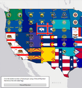
@DonKemlage created a guide for filling your polygon layers with images using ArcGIS Runtime SDK for .NET. See the example using C# code for a Windows Presentation Foundation (WPF) app that displays a map of state flags for the United States with the UniqueValueRenderer. Read How to Use PictureFillSymbols
Place of the Week: ArcGIS Spatial Analyst
Connect with other users in the ArcGIS Spatial Analyst place to ask questions, see what’s new from the latest ArcGIS Pro 2.8 release, and learn from other users by checking out discussions and Accepted Solutions.
Go to: ArcGIS Spatial Analyst
3 Open Questions & Discussions
Share your knowledge by helping out users with open questions and earn recognition in Esri Community.
@OldManStrength wants to know how to use ArcGIS GeoEvent Server to trigger an e-mail when a status of a hydrant is changed. Do you have a workflow you can share?
@mathanesricom is looking for the best way to update coronavirus cases in real-time. Take a look at the scenario and issue details and see if you can help.
@sharathgh is working on the join feature using JoinOperation REST API and needs to create a feature service layer from a CSV file. Can you provide some guidance?
🤝 Meet a Community Member in our Introductions Board. Meet Members >>
9 Product and Service Updates
Esri Training announced the Imagery MOOC will start on August 11. Learn More
Esri Technical Certification has a new blog for understanding how to maintain your training and certification records through your career and academic changes. Learn More
Implementing ArcGIS has a new blog for running an Apache JMeter Load Test from Command-line mode. Read More
ArcGIS GeoEvent Server has a new document for preventing GeoEvent from sending previous e-mails when the server reboots. Learn More
INSPIRE has a new blog for how to create INSPIRE Metadata v2 with an ArcGIS Pro add-in. Read More
ArcGIS Maps for Adobe Creative Cloud announced Adobe Illustrator version 25.3 is not supported with ArcGIS Maps for Adobe Creative Cloud. Learn More
Telecommunications posted a new entry in their Telecom GIS in Five Minutes Video Series about reimagining network high-level design. Watch Video
Architecture, Engineering, and Constructions (AEC) posted a preview of the 2021 Esri User Conference sessions to catch from the AEC industry. Watch Video
User Conference 2021: New fliers have been added to the User Conference Documents board.
---------------------------------------
Got an idea or suggestion for future weekly updates? Comment below or contact us at esricommunity@esri.com.
Follow @EsriCommunity_ on Twitter.
You must be a registered user to add a comment. If you've already registered, sign in. Otherwise, register and sign in.