- Home
- :
- All Communities
- :
- Products
- :
- ArcGIS StoryMaps
- :
- Classic Esri Story Maps Questions
- :
- Re: Crowdsource - how do I download my pictures?
- Subscribe to RSS Feed
- Mark Topic as New
- Mark Topic as Read
- Float this Topic for Current User
- Bookmark
- Subscribe
- Mute
- Printer Friendly Page
Crowdsource - how do I download my pictures?
- Mark as New
- Bookmark
- Subscribe
- Mute
- Subscribe to RSS Feed
- Permalink
- Report Inappropriate Content
So the old Crowdsource app was awesome. What if I want to batch download ALL of the photos from it though?
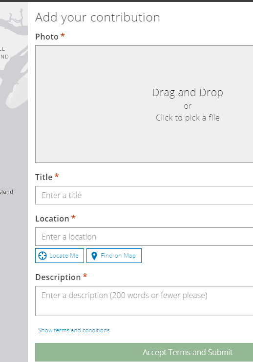
The new templates are more cumbersome; I created this in like 1 minute.
Ideally, exporting the Hosted Feature Layer that I used with it, which it generates on AGOL out of the box, would download not only the points to a fGDB but also a relate with the photos as attachments in the gdb. It doesn't. That is disappointing. I wish I could at least download the photos and they'd some sort of ID or something that could link them to the points.
I found that if I go to the featureLayer REST page and do the old 1=1 query trick, I can view them all.
But... is there a better way?
Also I noticed it seems to grab EXIF from uploaded images if they have geotag, and locate the image. But unfortunately it strips away the very, very valuable EXIF when I download the photo (from the URL I found in F12) First, I would advise Esri to always, always preserve EXIF. For timestamp and geotag.
So I was wondering also - is there any way with this Classic template, to determine when the actual photo was taken?
IF not, I guess I'll have to stick a text note somewhere, advising users to note the actual date the photo was taken, if they are uploading a photo that had been taken previously.
And if that is what I have to do as the workaround (not ideal)... is there any way to change the text where it says "Description" to put such a text note? Since it's hosted I'm guessing no. Is there any way I can download this app so I can put it on my server and tweak the source?
- Mark as New
- Bookmark
- Subscribe
- Mute
- Subscribe to RSS Feed
- Permalink
- Report Inappropriate Content
Ok... another question, how do I delete photos? ---- update: hats off to Tech Support as always. I had to go in to the feature layer's permissions, and enable Delete. By default it only has Add and Update. Then I deleted the points through the webmap.
Sidenote, this is a use case where directly being able to batch update through the webmap attribute table could come in handy, if I ever needed to delete many records at once, perhaps of a given date range in this example.