- Home
- :
- All Communities
- :
- User Groups
- :
- Cartography and Maps
- :
- Questions
- :
- Re: Clipping Map Frames to irregular shapes in Arc...
- Subscribe to RSS Feed
- Mark Topic as New
- Mark Topic as Read
- Float this Topic for Current User
- Bookmark
- Subscribe
- Mute
- Printer Friendly Page
Clipping Map Frames to irregular shapes in ArcGIS Pro?
- Mark as New
- Bookmark
- Subscribe
- Mute
- Subscribe to RSS Feed
- Permalink
- Report Inappropriate Content
During ArcGIS Pro 2.0 Beta I asked whether Clipping the Data Frame functionality from ArcMap would be coming to ArcGIS Pro so that I would be able to graphically clip layers to irregular polygons that were map sheet boundaries defined as rectangles in decimal degrees, that become non-rectangular when projected on-the-fly to MGA/UTM Zones.
Feedback at the time (with no specific version number mentioned) had me hopeful that I might see it by ArcGIS Pro 2.1. However, it still does not seem to be in the ArcGIS Pro Roadmap.
It may just be that the roadmap is too granular to show it but is there any word on which version may have this functionality?
The ArcGIS Idea for this says that it is In Product Plan.
- Mark as New
- Bookmark
- Subscribe
- Mute
- Subscribe to RSS Feed
- Permalink
- Report Inappropriate Content
KKramer-esristaff is it on the fine-grained list?
- Mark as New
- Bookmark
- Subscribe
- Mute
- Subscribe to RSS Feed
- Permalink
- Report Inappropriate Content
If the OP is referring to reshaping the data frame this has already been implemented. Go to the Layout view, select the Map Frame from the contents pane and use one of the options provided in Reshape:
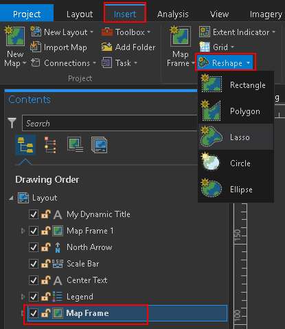
You can reshape the data frame:

You can also use a layer to clip the extent, by entering the properties of the Map:
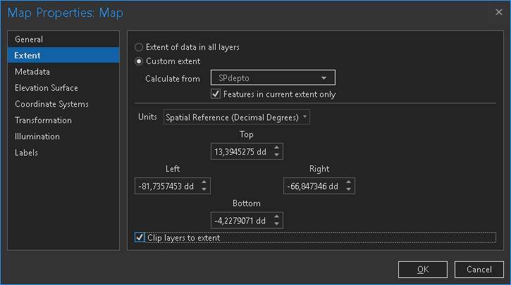
Although it seems to be using the extent of the selected layer and not the feature geometry itself to do the clip.
- Mark as New
- Bookmark
- Subscribe
- Mute
- Subscribe to RSS Feed
- Permalink
- Report Inappropriate Content
Yes, it's on the list as pointed out in the original description (the idea is marked as In Product Plan).
graeme it sounds like you are specifically looking for this in an ArcGIS Pro Map View, correct? Rather than a layout. As xander_bakker points out, it can be done in a layout - the piece that needs to be added to that workflow in ArcGIS Pro is to use an existing shape in the layout.
And then there is the request to have this in the map view itself. Can you clarify which is relevant to your work?
Thank you.
- Mark as New
- Bookmark
- Subscribe
- Mute
- Subscribe to RSS Feed
- Permalink
- Report Inappropriate Content
Thanks Kory and Xander
The key thing is that the main map on the layout is bordered by an irregular polygon.
It is defined as a rectangle in lat/long, but the map has to be presented in a projected coordinate system (usually one of three MGA Zones, sometimes Albers/Lamberts), and so the rectangle becomes a distorted "rectangle" with many thousands of vertices. This distorted rectangle is available as a polygon feature in a feature class.
What I am looking for is to be able to set a read-write property of a MapFrame object to set a graphic clip by the only polygon in a file geodatabase feature class, and to be able change that property to be another feature class when required.
The grids and graticules, data and MapFrame border already seem to graphically clip to a free-hand polygon so the main block (besides ArcPy accessibility) seems to be that the clipping polygon cannot be specified as a polygon feature.
- Mark as New
- Bookmark
- Subscribe
- Mute
- Subscribe to RSS Feed
- Permalink
- Report Inappropriate Content
Kory and Xander
I thought I saw the ability to use a polygon feature (not just a digitized graphic) to reshape a Map Frame in ArcGIS Pro 2.3 Beta 2. but when I looked at ArcGIS Pro 2.3.0 just now it looks like the only way to graphically clip using a polygon a Map Frame is still by digitizing it.
Did that functionality not make it into 2.3 Final, or did I imagine it?
- Mark as New
- Bookmark
- Subscribe
- Mute
- Subscribe to RSS Feed
- Permalink
- Report Inappropriate Content
I can see now that it has been added to Map Properties which helps for some requirements like simple exporting of a clipped image or basemap - see https://gis.stackexchange.com/q/311315/115.
I can put the clipped Map into a rectangular MapFrame with an invisible border to achieve a "pseudo clipped map frame".
Can the Map class now be given a clipLayer property for ArcPy to access, please?
Unfortunately, a "pseudo clipped map frame" will not allow me to put grids and graticules along the graphic clipping feature's edge.
I think we still need a clipLayer property on the MapFrame class too.