Turn on suggestions
Auto-suggest helps you quickly narrow down your search results by suggesting possible matches as you type.
Cancel
- Home
- :
- All Communities
- :
- Developers
- :
- ArcObjects SDK
- :
- ArcObjects SDK Questions
- :
- How to use 3D Symbol with IFeatureLayer (GlobeCont...
Options
- Subscribe to RSS Feed
- Mark Topic as New
- Mark Topic as Read
- Float this Topic for Current User
- Bookmark
- Subscribe
- Mute
- Printer Friendly Page
How to use 3D Symbol with IFeatureLayer (GlobeControl)
Subscribe
1986
1
03-23-2012 05:46 AM
by
Anonymous User
Not applicable
03-23-2012
05:46 AM
- Mark as New
- Bookmark
- Subscribe
- Mute
- Subscribe to RSS Feed
- Permalink
- Report Inappropriate Content
Original User: fabpuddu
Hi,
I used 3D Symbol in GlobeControl using IGlobeGraphicsLayer and AddElement, and work fine.
Now I'm trying to using IFeatureLayer but I have a problem with .3DS symbol.
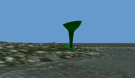
The symbol not displayed in 3D but it seems on the surface, the symbol does not seem to be the symbols loaded and displays a label '3D Marker'
In attachments the symbol using GraphicLayer and using FeatureLayer
I can manage 3D symbols using IFeatureLayer ? How I can do ?
This is my code:
Dim pFeatureClass As IFeatureClass
pFeatureClass = CreateFeatureClass(esriGeometryType.esriGeometryPoint)
Dim pFLy As IFeatureLayer
pFLy = New FeatureLayer
With pFLy
.FeatureClass = pFeatureClass
.Name = m_NameLayer
.Cached = True
.Selectable = True
End With
Dim marker3dSymbol As IMarker3DSymbol = New Marker3DSymbol
marker3dSymbol.CreateFromFile("C:\\SVILUPPO\\Software\\Prove\\Test-Globe\\TestGlobe\\bar-chair-00024.3DS")
marker3dSymbol.UseMaterialDraping = True
TryCast(marker3dSymbol, IMarkerSymbol).Size = 50
Dim pColor As IColor = New RgbColor
pColor.RGB = RGB(0, 255, 0)
pColor.Transparency = 255
Dim pMarker3DPlace As IMarker3DPlacement
pMarker3DPlace = marker3dSymbol
pMarker3DPlace.Size = 50
pMarker3DPlace.Color = pColor
pMarker3DPlace.Units = esriUnits.esriMeters
Dim pRend As IFeatureRenderer
Dim pSimpleRend As ISimpleRenderer
Dim pGeoFL As IGeoFeatureLayer
' create a new CustomSimpleRend
pRend = New SimpleRenderer
' set symbol. we must use ISimpleRenderer interface
pSimpleRend = pRend
pSimpleRend.Symbol = TryCast(marker3dSymbol, ISymbol)
pGeoFL = pFLy
pGeoFL.ScaleSymbols = True
' set the new renderer to the layer and refresh the map
pGeoFL.Renderer = pRend
m_objGlobeControl.Globe.AddLayerType(TryCast(pFLy, ILayer), esriGlobeLayerType.esriGlobeLayerTypeDraped, True)
Thanks at all
fabrizio
Hi,
I used 3D Symbol in GlobeControl using IGlobeGraphicsLayer and AddElement, and work fine.
Now I'm trying to using IFeatureLayer but I have a problem with .3DS symbol.
The symbol not displayed in 3D but it seems on the surface, the symbol does not seem to be the symbols loaded and displays a label '3D Marker'
In attachments the symbol using GraphicLayer and using FeatureLayer
I can manage 3D symbols using IFeatureLayer ? How I can do ?
This is my code:
Dim pFeatureClass As IFeatureClass
pFeatureClass = CreateFeatureClass(esriGeometryType.esriGeometryPoint)
Dim pFLy As IFeatureLayer
pFLy = New FeatureLayer
With pFLy
.FeatureClass = pFeatureClass
.Name = m_NameLayer
.Cached = True
.Selectable = True
End With
Dim marker3dSymbol As IMarker3DSymbol = New Marker3DSymbol
marker3dSymbol.CreateFromFile("C:\\SVILUPPO\\Software\\Prove\\Test-Globe\\TestGlobe\\bar-chair-00024.3DS")
marker3dSymbol.UseMaterialDraping = True
TryCast(marker3dSymbol, IMarkerSymbol).Size = 50
Dim pColor As IColor = New RgbColor
pColor.RGB = RGB(0, 255, 0)
pColor.Transparency = 255
Dim pMarker3DPlace As IMarker3DPlacement
pMarker3DPlace = marker3dSymbol
pMarker3DPlace.Size = 50
pMarker3DPlace.Color = pColor
pMarker3DPlace.Units = esriUnits.esriMeters
Dim pRend As IFeatureRenderer
Dim pSimpleRend As ISimpleRenderer
Dim pGeoFL As IGeoFeatureLayer
' create a new CustomSimpleRend
pRend = New SimpleRenderer
' set symbol. we must use ISimpleRenderer interface
pSimpleRend = pRend
pSimpleRend.Symbol = TryCast(marker3dSymbol, ISymbol)
pGeoFL = pFLy
pGeoFL.ScaleSymbols = True
' set the new renderer to the layer and refresh the map
pGeoFL.Renderer = pRend
m_objGlobeControl.Globe.AddLayerType(TryCast(pFLy, ILayer), esriGlobeLayerType.esriGlobeLayerTypeDraped, True)
Thanks at all
fabrizio
1 Reply
03-26-2012
12:48 AM
- Mark as New
- Bookmark
- Subscribe
- Mute
- Subscribe to RSS Feed
- Permalink
- Report Inappropriate Content
anyone can help me?
thanks
thanks