Turn on suggestions
Auto-suggest helps you quickly narrow down your search results by suggesting possible matches as you type.
Cancel
- Home
- :
- All Communities
- :
- Developers
- :
- ArcObjects SDK
- :
- ArcObjects SDK Questions
- :
- How to get top (or visibles) polygons in specific ...
Options
- Subscribe to RSS Feed
- Mark Topic as New
- Mark Topic as Read
- Float this Topic for Current User
- Bookmark
- Subscribe
- Mute
- Printer Friendly Page
How to get top (or visibles) polygons in specific Layer with ArcObjects
Subscribe
750
1
02-16-2013 03:05 AM
02-16-2013
03:05 AM
- Mark as New
- Bookmark
- Subscribe
- Mute
- Subscribe to RSS Feed
- Permalink
- Report Inappropriate Content
Hi everyone!
I need to create an ArcObjects function to get the top (or visibles) polygons in specific layer. It's possible? I have a Layer with a lot of polygons in the same area but i have to get the top or visibles. I think it's not possible using ISpatialFilter! 😞
Thank´s a lot!
I need to create an ArcObjects function to get the top (or visibles) polygons in specific layer. It's possible? I have a Layer with a lot of polygons in the same area but i have to get the top or visibles. I think it's not possible using ISpatialFilter! 😞
Thank´s a lot!
1 Reply
02-18-2013
05:29 AM
- Mark as New
- Bookmark
- Subscribe
- Mute
- Subscribe to RSS Feed
- Permalink
- Report Inappropriate Content
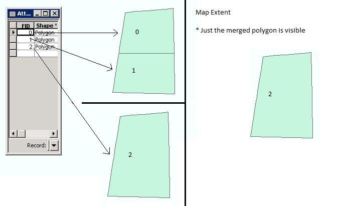
All 3 of those features are visible; it's just that the merged feature is drawn last and hides the two smaller features that are in the same location. There's no real way to tell which feature is "on top" but from my own observation it always appears to be the feature with the higher ObjectId. My guess is that ArcMap renders the features in the order of their ObjectIds but I'm not certain that is always the case. If you need to be able to identify the merged features from the original features within a feature layer then I would suggest adding a field to the layer's attribute table that holds this information. You can then add an attribute query to your spatial filter in order to get the results you are looking for.