- Home
- :
- All Communities
- :
- Products
- :
- ArcMap
- :
- ArcMap Questions
- :
- List By Source and Layer Properties show different...
- Subscribe to RSS Feed
- Mark Topic as New
- Mark Topic as Read
- Float this Topic for Current User
- Bookmark
- Subscribe
- Mute
- Printer Friendly Page
List By Source and Layer Properties show different source
- Mark as New
- Bookmark
- Subscribe
- Mute
- Subscribe to RSS Feed
- Permalink
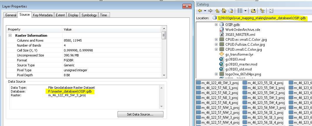
I have a perplexing issue where List By Source shows the correct UNC path, but Data Source in layer properties shows the named letter drive. Running findAndReplaceWorkspacePaths did not fix the issue.
Here is a screenshot showing List By Source:

And then here is a screenshot showing the layer Properties:

- Mark as New
- Bookmark
- Subscribe
- Mute
- Subscribe to RSS Feed
- Permalink
This is often a source of frustration when publishing when I accidentally add the data from a mapped drive connection. I've found that adjusting the data source has no effect, the only solution being to add the data to a new MXD using the intended source path.
- Mark as New
- Bookmark
- Subscribe
- Mute
- Subscribe to RSS Feed
- Permalink
Thanks for the reply, David. Yeah, what I did to try and fix was removed the offending rasters and then added them again. When I use python to list the layers' data source, they list with the correct unc source now (before removing/adding back they were listed as a fun hodge podge of both), but when I look at layer properties, they still show the letter drive. I guess I could try starting again with a new mxd.
- Mark as New
- Bookmark
- Subscribe
- Mute
- Subscribe to RSS Feed
- Permalink
Ugh, just tried adding the rasters to a brand new empty map, from the UNC path. Still shows the letter drive when I go to layer properties (screenshot attached). The really weird thing is, I have another set of rasters that sits in a separate fgdb in the same folder as this one, and they show the expected source in layer properties without any issues.

- Mark as New
- Bookmark
- Subscribe
- Mute
- Subscribe to RSS Feed
- Permalink
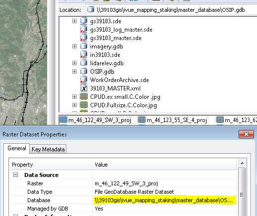
And yet, when I open raster properties from inside ArcCatalog, it lists the correct source:

- Mark as New
- Bookmark
- Subscribe
- Mute
- Subscribe to RSS Feed
- Permalink
Possibly remove any folder connections specifying the mapped path, both in ArcMap and Catalog. Attempt to add them from drag-n-drop from Catalog to Map, Map catalog window to TOC and 'Add Data'.
Try on another user profile then open the MXD back on your profile.
Last would be the nuclear option of un-mapping the drive.
- Mark as New
- Bookmark
- Subscribe
- Mute
- Subscribe to RSS Feed
- Permalink
David, thanks so much for putting me on the right path (get it?). I tried removing the folder connection--same problem. I contemplated how I might try on another user profile, since I'm basically the only ArcMap user at my organization anyway, and I'm also working remotely right now. That got me thinking though, that the user profile is basically just the Normal.mxt, so I renamed it, and voila! Fixed! I was able to add these rasters back to my existing map and they show the correct path! Most likely I could have left my folder connection, and just renamed the Normal.mxt. Good old esri--just try random stuff until something works. ![]() Really appreciate your help.
Really appreciate your help.
- Mark as New
- Bookmark
- Subscribe
- Mute
- Subscribe to RSS Feed
- Permalink
I did think about the normal.mxt then dismissed it as 'that can't possibly ever cause this issue'. Glad it worked in the end.
That pun is however unforgivable.