- Home
- :
- All Communities
- :
- Products
- :
- ArcMap
- :
- ArcMap Questions
- :
- ArcMap GPS to Features conversion tool data column...
- Subscribe to RSS Feed
- Mark Topic as New
- Mark Topic as Read
- Float this Topic for Current User
- Bookmark
- Subscribe
- Mute
- Printer Friendly Page
ArcMap GPS to Features conversion tool data columns missing in attribute table
- Mark as New
- Bookmark
- Subscribe
- Mute
- Subscribe to RSS Feed
- Permalink
- Report Inappropriate Content
I'm using ArcMap version 10.8.1 I'm trying to use the GPX to Features conversion tool. When the GPX file is converted and added to the map, the attribute table is missing columns from the original data. I tried re-labelling some of the data but that didn't help. I was not able to upload the GPX file so I uploaded an image of a small sample of the GPX data.
Solved! Go to Solution.
Accepted Solutions
- Mark as New
- Bookmark
- Subscribe
- Mute
- Subscribe to RSS Feed
- Permalink
- Report Inappropriate Content
Hi Dan, thank you so much for your help. The GPX data represents campsites. Many of the campsites have a rating. The ratings are 1 through 5. The rating numbers can also be 3.5, 4.7, etc. I'm able to edit the gpx data so I first tried this <rating>4</rating>, that didn't work so I tried putting the rating numbers into the <Descript>2<Descript> tag and I also tried putting the ratings into the <Comment>3</Comment> tag. The <rating> tag is not represented in the Attribute table. The attribute table has fields for Description / Descript and Comment but the data in those tags does not appear in the attribute table.
My goal is to add these campsites to my map and then display the rating number as part of the "symbol" for the campsite, or if that is not possible, somehow have the rating print on the map near the campsite symbol.
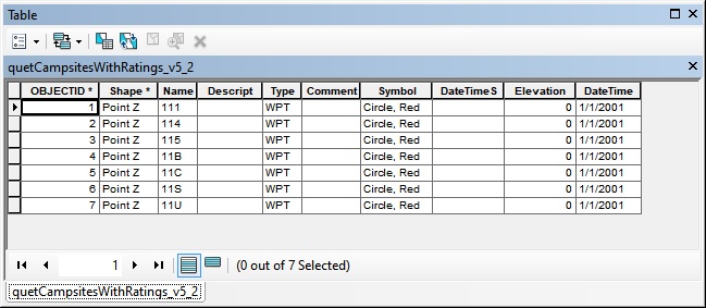
EDIT/UPDATE: after running some tests it looks like the GPX to Features conversion tool in ArcMap automatically builds an attribute table with the following columns:
OBJECTID, Shape, Name, Descript, Type, Comment, Symbol, DateTimeS, Elevation, DateTime
The attribute table has those columns whether those tags exist in the GPX file or not. Also, if other tags are in the GPX file, for example, <rating> the tool does not add those to the attribute table. Also, if the GPX file has data tagged as <Comment> or <Descript> that data does not populate into the attribute table.
I am testing adding a tag to the GPX file that has the rating for each campsite <rating>4</rating> and then using online GPX to Shape converter to add the data to the map as a Shape file. If that works, hopefully there will be a way to set the rating to show as part of the symbol.
UPDATE: my first try converting gpx to shapefile did not convert the ratings into the shapefile attribute table.
UPDATE: I put the ratings data into the <type> tag in the GPX data file. Then I used the website listed above to convert the GPX file into a Shapefile. Then I added the Shapefile to the map and in the Table of Contents I right-clicked on the shapefile data and clicked Label Features. As far as I know, Label Features will only apply the <type> field as the label. This "hack" worked although I am sure there is a more elegant and proper solution.
- Mark as New
- Bookmark
- Subscribe
- Mute
- Subscribe to RSS Feed
- Permalink
- Report Inappropriate Content
can you specify which fields are missing to make a comparison easier since you can't view the *jpg files side-by-side.
Obviously, the long/lat fields have been used in the creation of geometry, but they can be retrieved using
Add Geometry Attributes (Data Management)—ArcGIS Pro | Documentation
... sort of retired...
- Mark as New
- Bookmark
- Subscribe
- Mute
- Subscribe to RSS Feed
- Permalink
- Report Inappropriate Content
Hi Dan, thank you so much for your help. The GPX data represents campsites. Many of the campsites have a rating. The ratings are 1 through 5. The rating numbers can also be 3.5, 4.7, etc. I'm able to edit the gpx data so I first tried this <rating>4</rating>, that didn't work so I tried putting the rating numbers into the <Descript>2<Descript> tag and I also tried putting the ratings into the <Comment>3</Comment> tag. The <rating> tag is not represented in the Attribute table. The attribute table has fields for Description / Descript and Comment but the data in those tags does not appear in the attribute table.
My goal is to add these campsites to my map and then display the rating number as part of the "symbol" for the campsite, or if that is not possible, somehow have the rating print on the map near the campsite symbol.
EDIT/UPDATE: after running some tests it looks like the GPX to Features conversion tool in ArcMap automatically builds an attribute table with the following columns:
OBJECTID, Shape, Name, Descript, Type, Comment, Symbol, DateTimeS, Elevation, DateTime
The attribute table has those columns whether those tags exist in the GPX file or not. Also, if other tags are in the GPX file, for example, <rating> the tool does not add those to the attribute table. Also, if the GPX file has data tagged as <Comment> or <Descript> that data does not populate into the attribute table.
I am testing adding a tag to the GPX file that has the rating for each campsite <rating>4</rating> and then using online GPX to Shape converter to add the data to the map as a Shape file. If that works, hopefully there will be a way to set the rating to show as part of the symbol.
UPDATE: my first try converting gpx to shapefile did not convert the ratings into the shapefile attribute table.
UPDATE: I put the ratings data into the <type> tag in the GPX data file. Then I used the website listed above to convert the GPX file into a Shapefile. Then I added the Shapefile to the map and in the Table of Contents I right-clicked on the shapefile data and clicked Label Features. As far as I know, Label Features will only apply the <type> field as the label. This "hack" worked although I am sure there is a more elegant and proper solution.
- Mark as New
- Bookmark
- Subscribe
- Mute
- Subscribe to RSS Feed
- Permalink
- Report Inappropriate Content
sometimes "hacks" are the best solution... marking this answered in light of this
... sort of retired...