- Home
- :
- All Communities
- :
- Products
- :
- ArcGIS Web AppBuilder
- :
- ArcGIS Web AppBuilder Questions
- :
- Re: Looking for best practice to have images attac...
- Subscribe to RSS Feed
- Mark Topic as New
- Mark Topic as Read
- Float this Topic for Current User
- Bookmark
- Subscribe
- Mute
- Printer Friendly Page
Looking for best practice to have images attached to a web map pop-up..
- Mark as New
- Bookmark
- Subscribe
- Mute
- Subscribe to RSS Feed
- Permalink
- Report Inappropriate Content
I am building a sewer map and have scanned in images for each manhole (500+). It would be nice to be able to have access to them in the field.
What would others recommend as far as storage and copying the url into the data for each manhole?
Since there are so many, I need something painless. Thanks for any advice!
- Mark as New
- Bookmark
- Subscribe
- Mute
- Subscribe to RSS Feed
- Permalink
- Report Inappropriate Content
Hi Darla - Just want to get this in the thread for those finding it later as a resource. Pictures as attachments in the geodatabase are the easiest way to access them via pop-ups across the platform.
Enabling attachments—ArcGIS Help | ArcGIS Desktop
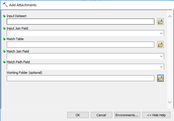
In your case, how are the images stored? In ArcGIS Pro, there is a GP tool to mass create and load the pictures as attachments. You would need an intermediate table that has the linkage between the images and the manholes, but the result would be attachments and most likely the simplest way to display the images in an application.
Add Attachments—Data Management toolbox | ArcGIS Desktop
-Adam Z
- Mark as New
- Bookmark
- Subscribe
- Mute
- Subscribe to RSS Feed
- Permalink
- Report Inappropriate Content
Yes, this is the answer I was looking for.
Unfortunately, I only have the basic license...it looks like I may have to budget for an upgraded license.
Intermediate table? I am already using a spreadsheet. Would that qualify? And I see that this uses the ArcPy, which is new conceptually to me. Looks like I may need to get a little smarter.
I am unsure how I am going to store my images, I would like to utilize ArcGIS Online. We are not wanting to make the jump to Server. Looking for recommendations...
Thanks!
- Mark as New
- Bookmark
- Subscribe
- Mute
- Subscribe to RSS Feed
- Permalink
- Report Inappropriate Content
Hi Darla - Yeah, unfortunately you'll need at least a Standard license. The spreadsheet will work, you'll just need to load it as a table so that the tool can work with it. You can use ArcPy, but it is also available as a GP Tool in both ArcMap and ArcGIS Pro.
By adding as attachments, you would simply publish to ArcGIS Online and the attachments will go with the features.
-Adam Z