- Home
- :
- All Communities
- :
- Products
- :
- ArcGIS Web AppBuilder
- :
- ArcGIS Web AppBuilder Questions
- :
- Re: layers out of range greyed out
- Subscribe to RSS Feed
- Mark Topic as New
- Mark Topic as Read
- Float this Topic for Current User
- Bookmark
- Subscribe
- Mute
- Printer Friendly Page
- Mark as New
- Bookmark
- Subscribe
- Mute
- Subscribe to RSS Feed
- Permalink
out of visibility range layers do not grey out in the webapp builder layer list widget, can this be changed programmatically?
Solved! Go to Solution.
- Mark as New
- Bookmark
- Subscribe
- Mute
- Subscribe to RSS Feed
- Permalink
the newer version of LayerListView from 1.3 differs at line 175/176
| ckSelect = new CheckBox({ | |
| checked: layerInfo.isVisible(), //layerInfo.visible | |
| 'class': "visible-checkbox-" + layerInfo.id | |
| }) |
does the newer syntax need to be added?
- Mark as New
- Bookmark
- Subscribe
- Mute
- Subscribe to RSS Feed
- Permalink
THANKS!
- Mark as New
- Bookmark
- Subscribe
- Mute
- Subscribe to RSS Feed
- Permalink
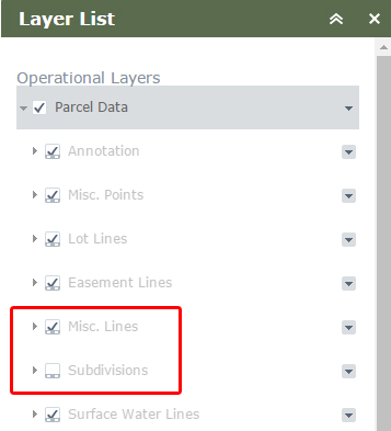
Robert-- Just plugged the 1.3 version in and noticing a small issue or two. One feature service in the map has 5 layers. All 5 layers have the same visibility extent setting. When zoomed to that scale, all the layers display on the map as they should, however two of them are greyed out as if not visible. I can still toggle them off and on and the map responds appropriately. I confirmed in ArcMap that the visible scales are the same for all layers. Any idea if this is something that needs fixed on my end?
- Mark as New
- Bookmark
- Subscribe
- Mute
- Subscribe to RSS Feed
- Permalink
Cole,
I have done some testing and I can not reproduce this.
- Mark as New
- Bookmark
- Subscribe
- Mute
- Subscribe to RSS Feed
- Permalink
It's been a few months since Cole's post, but I'm curious if this was his problem: With this modification, the first time you open the Layer List widget, all layer names inside of a map service appear grayed out until you zoom in or out. After that everything behaves as expected.
- Mark as New
- Bookmark
- Subscribe
- Mute
- Subscribe to RSS Feed
- Permalink
Ryan,
See this reply for a fix to that: https://community.esri.com/thread/161457#comment-549382
- Mark as New
- Bookmark
- Subscribe
- Mute
- Subscribe to RSS Feed
- Permalink
Thank you!! This has been annoying me for so long, I can't believe the fix was right there! D'oh!
- Mark as New
- Bookmark
- Subscribe
- Mute
- Subscribe to RSS Feed
- Permalink
works in 1.2. PERFECT.