Turn on suggestions
Auto-suggest helps you quickly narrow down your search results by suggesting possible matches as you type.
Cancel
- Home
- :
- All Communities
- :
- Products
- :
- ArcGIS Viewer for Flex (Retired)
- :
- ArcGIS Viewer for Flex Questions
- :
- Identify Widget 3.6.2 for Flex Viewer: raster laye...
Options
- Subscribe to RSS Feed
- Mark Topic as New
- Mark Topic as Read
- Float this Topic for Current User
- Bookmark
- Subscribe
- Mute
- Printer Friendly Page
Identify Widget 3.6.2 for Flex Viewer: raster layer names will not display
Subscribe
01-21-2014
01:32 PM
- Mark as New
- Bookmark
- Subscribe
- Mute
- Subscribe to RSS Feed
- Permalink
Using the 3.6.2 version of the Identify Widget, I cannot get names of attributed, ERDAS Imagine (.img) raster layers to display when I click on a pixel in the Flex app to identify. In the 3.0.2 version of the widget for Flex Viewer 3.0, the layer name would be displayed for these raster layers. How can I get the layer name to be displayed along with the other results? I am using ArcGIS 10.2 for Server and Flex Viewer 3.6, on Windows Server 2008 R2 x64. I have not installed the Flex API, just the Flex Viewer.
Behavior is the same with widget version 3.5.1 for Flex Viewer 3.5.
Layer names for vector layers are displayed with Identify results, just not the layer names of the Imagine .img files. In Widget settings, if I try and add a layer from one of these rasters, the services are seen, but no "addable" features are shown, so I cannot add them.
In my current xml configuration for the widget, I completely removed the <layers> section. So there is no layer info in the xml for any layer. Everything seems to work fine except for the .img layers for which no layer names are displayed.
This image shows identify results on one of the .img files using Identify widget 3.0.2 in Flex Viewer 3.0, using ArcGIS for Server 10.0 (sp5), in Firefox:
[ATTACH=CONFIG]30682[/ATTACH]
This image shows identify results on one of the .img files using Identify widget 3.6.2 in Flex Viewer 3.6, using ArcGIS 10.2 for Server, in Firefox:
[ATTACH=CONFIG]30683[/ATTACH]
Thank you in advance...
Solved! Go to Solution.
32 Replies
02-24-2014
05:10 AM
- Mark as New
- Bookmark
- Subscribe
- Mute
- Subscribe to RSS Feed
- Permalink
Kinga,
I will have to do some testing on that exact senario.
I will have to do some testing on that exact senario.
by
Anonymous User
Not applicable
02-24-2014
05:41 AM
- Mark as New
- Bookmark
- Subscribe
- Mute
- Subscribe to RSS Feed
- Permalink
Original User: Pingu
Robert,
thanks again, waiting for your answer
Robert,
thanks again, waiting for your answer
by
Anonymous User
Not applicable
02-25-2014
04:51 AM
- Mark as New
- Bookmark
- Subscribe
- Mute
- Subscribe to RSS Feed
- Permalink
Original User: Pingu
Robert,
would you be so kind to send me the xml code of your configuration? I would crosscheck it with the one I used.
Robert,
would you be so kind to send me the xml code of your configuration? I would crosscheck it with the one I used.
by
Anonymous User
Not applicable
02-25-2014
05:06 AM
- Mark as New
- Bookmark
- Subscribe
- Mute
- Subscribe to RSS Feed
- Permalink
Original User: Pingu
Robert,
thanks a lot, I'll test with this.
Robert,
thanks a lot, I'll test with this.
02-26-2014
10:39 AM
- Mark as New
- Bookmark
- Subscribe
- Mute
- Subscribe to RSS Feed
- Permalink
I have tried ~20 times, using 3 different browsers, to post a new thread that is related to this one, but the attempts time out every time. What is going on with this forum? :mad:
by
Anonymous User
Not applicable
02-26-2014
10:51 AM
- Mark as New
- Bookmark
- Subscribe
- Mute
- Subscribe to RSS Feed
- Permalink
Original User: brESRI
Ok, I have wasted enough time attempting to make a new thread, so here is another question which I hope Robert can answer.
-----------------------------------------------------------
Hello again, I have another question for Robert regarding XML configuration of the ID widget for raster layers.
I am using Identify Widget 3.0.2 for Flex Viewer 3.0 with ArcGIS Server 10 and cannot upgrade to newer versions of Server or Flex at this time.
I want to configure the ID widget xml for raster layers so that only certain fields are reported (in this case the "MaterialID" and pixel value attributes). Here is the raster layer:
http://cmerwebmap.cr.usgs.gov/ArcGIS/rest/services/Landsat7_West/MapServer/2
Using this xml,
I get this ID result:
[ATTACH=CONFIG]31801[/ATTACH]
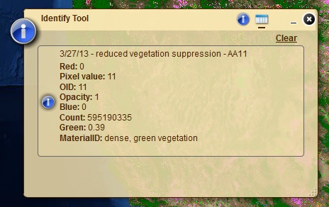
which is the same as if I didn't alter the XML at all. Nearly the same XML as shown above works perfectly on the same raster layer using ID Widget 3.6.4 and Server 10.2.1 (see image below):
[ATTACH=CONFIG]31802[/ATTACH]
Is there a way to configure the XML to limit the displayed fields reported for this raster?
Thank you in advance, Robert! 🙂
Ok, I have wasted enough time attempting to make a new thread, so here is another question which I hope Robert can answer.
-----------------------------------------------------------
Hello again, I have another question for Robert regarding XML configuration of the ID widget for raster layers.
I am using Identify Widget 3.0.2 for Flex Viewer 3.0 with ArcGIS Server 10 and cannot upgrade to newer versions of Server or Flex at this time.
I want to configure the ID widget xml for raster layers so that only certain fields are reported (in this case the "MaterialID" and pixel value attributes). Here is the raster layer:
http://cmerwebmap.cr.usgs.gov/ArcGIS/rest/services/Landsat7_West/MapServer/2
Using this xml,
<layers onlythese="false">
        <layer>
            <name>Landsat 7 - Northwestern U.S. - 3/27/13 - reduced vegetation suppression - AA11</name>
            <id>2</id>
            <url>http://cmerwebmap.cr.usgs.gov/ArcGIS/rest/services/Landsat7_West/MapServer</url>
            <fields>
                <field name="MaterialID" alias="Material ID"/>
                <field name="Value" alias="Pixel Value"/>
            </fields>
            <links/>
            <zoomscale>2000</zoomscale>
            <forcescale>true</forcescale>
        </layer>
I get this ID result:
[ATTACH=CONFIG]31801[/ATTACH]
which is the same as if I didn't alter the XML at all. Nearly the same XML as shown above works perfectly on the same raster layer using ID Widget 3.6.4 and Server 10.2.1 (see image below):
[ATTACH=CONFIG]31802[/ATTACH]
    <layers onlythese="false">
        <layer>
            <name>Landsat 7 - Northwestern U.S. - 3/27/13 - reduced vegetation suppression - AA11</name>
            <id>2</id>
            <url>http://servername_10.2.1/ArcGIS/rest/services/Landsat7_West/MapServer</url>
            <fields>
                <field name="MaterialID" alias="Material ID"/>
                <field name="Pixel Value" alias="Pixel Value"/>
            </fields>
            <links/>
            <zoomscale>2000</zoomscale>
            <forcescale>true</forcescale>
        </layer>
Is there a way to configure the XML to limit the displayed fields reported for this raster?
Thank you in advance, Robert! 🙂
by
Anonymous User
Not applicable
02-26-2014
11:26 AM
- Mark as New
- Bookmark
- Subscribe
- Mute
- Subscribe to RSS Feed
- Permalink
Original User: rscheitlin
Barnaby,
Not sure what is going on with you not being able to start a new thread but I am experiencing issues with the forums today as well.
Version 3.0 was pretty different when i came to configuring layers. Here is what works for me:
Barnaby,
Not sure what is going on with you not being able to start a new thread but I am experiencing issues with the forums today as well.
Version 3.0 was pretty different when i came to configuring layers. Here is what works for me:
        <layer>
            <name>3/27/13 - reduced vegetation suppression - AA11</name>
            <fields>
                <field name="MaterialID" alias="Material ID"/>
                <field name="Pixel value" alias="Value"/>
            </fields>
            <links/>
            <zoomscale>2000</zoomscale>
            <forcescale>true</forcescale>
        </layer>
02-26-2014
12:06 PM
- Mark as New
- Bookmark
- Subscribe
- Mute
- Subscribe to RSS Feed
- Permalink
YES!!!!!!!!!!!!!!!!!!!!!!!!! 😄 Thanks, Robert!
I now see that the <name> field is used to identify the layer, not the <id> field. Is it possible to change the name of the layer as displayed in the ID widget results? Changing the name for display purposes is one of the main reasons I am editing the xml.
I now see that the <name> field is used to identify the layer, not the <id> field. Is it possible to change the name of the layer as displayed in the ID widget results? Changing the name for display purposes is one of the main reasons I am editing the xml.