- Home
- :
- All Communities
- :
- Products
- :
- ArcGIS Survey123
- :
- ArcGIS Survey123 Questions
- :
- Re: The existing data service is not compatible wi...
- Subscribe to RSS Feed
- Mark Topic as New
- Mark Topic as Read
- Float this Topic for Current User
- Bookmark
- Subscribe
- Mute
- Printer Friendly Page
The existing data service is not compatible with the survey
- Mark as New
- Bookmark
- Subscribe
- Mute
- Subscribe to RSS Feed
- Permalink
- Report Inappropriate Content
Hi James Tedrick, Ismael Chivite,
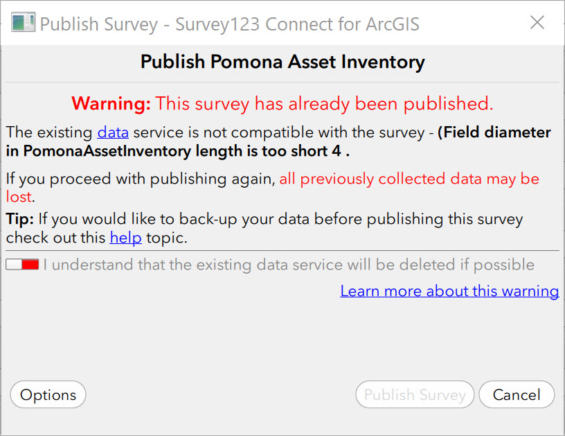
I have created a survey and published it in order to create the associated Feature Service. However, after making some edits to the XLS used to create the Survey and attempting to republish I am told "The existing data service is not compatible with the survey" as a field length is too short. However:
- I never edited this field so am confused why its changed length.
- If I look at the FS URL it's the same length as shown in the schema preview and error message.
- Even if I republish the survey (losing all data) then attempt to immediately republish again I get the same error.
Please can I ask for some advice on how to overcome this issue? My only solution presently is export data, republish, lose the FS and all data, append existing data to new FS and update the URLs of webmaps.

Thanks
- Mark as New
- Bookmark
- Subscribe
- Mute
- Subscribe to RSS Feed
- Permalink
- Report Inappropriate Content
Dariush,
Have you re-published this survey before? I see that error when the survey iteminfo isn't cleared from your local drive. Survey still reads this file as a published survey. After you delete the survey contents and folder from your AGOL account, if you haven't already tried, go into your local/C drive survey folder and delete this file, then try to republish your survey. This file will be recreated when you republish.

- Mark as New
- Bookmark
- Subscribe
- Mute
- Subscribe to RSS Feed
- Permalink
- Report Inappropriate Content
Adam,
Yes, I published it, then I removed the published files from my account and deleted the downloaded transcript in my devices which actually was used for collecting data. So, as you said correctly, the original files of the survey- including the TIMEINFO file, were still on drive C, because I didn't want to miss the survey. what I did to fix the problem was to make a copy of the survey under a new name, and published this new one and deleting the original Form 3 from my PC.
- Mark as New
- Bookmark
- Subscribe
- Mute
- Subscribe to RSS Feed
- Permalink
- Report Inappropriate Content
dailya I am experiencing the same thing as dameli@asu.edu - I created a whole new survey and feature service yet when I immediately attempt to republish I am presented with the same error as my original posting above. JTedrick-esristaff indicated this is an issue fixed in v2.7 but I am using v2.7.68. Right now I am unable to overwrite existing surveys...:(
- Mark as New
- Bookmark
- Subscribe
- Mute
- Subscribe to RSS Feed
- Permalink
- Report Inappropriate Content
Andrew,
The other thing to check is that the bind::esri:fieldLength column has not been set for that field - that would be a manual override of the length. I just verified with 2.7.68 that select_ones are being set to 255 characters using the 'Appearance' Sample available via Survey123 Connect.
- Mark as New
- Bookmark
- Subscribe
- Mute
- Subscribe to RSS Feed
- Permalink
- Report Inappropriate Content
I had to both make a brand new survey (from the the existing surveys XLSX) and clean out all values in bind::esri:fieldLength column before publishing this.
Now however I face the issue of how to get my existing records back into this new FS. As outlined below I am unable to "append" the existing records (which i downloaded into a GDB) as they contain attachments. Any ideas?
- Mark as New
- Bookmark
- Subscribe
- Mute
- Subscribe to RSS Feed
- Permalink
- Report Inappropriate Content
Hi Andrew,
I would suggest using ArcGIS Online's Append capability.
- Mark as New
- Bookmark
- Subscribe
- Mute
- Subscribe to RSS Feed
- Permalink
- Report Inappropriate Content
As mentioned below I don't have the "Append" capability on the FS generated as part of (re)publishing my S123.
Thanks
- Mark as New
- Bookmark
- Subscribe
- Mute
- Subscribe to RSS Feed
- Permalink
- Report Inappropriate Content
Append tool won't work if you have synchronization or editor tracking for created or updated features enabled. Make sure these are turned off in your feature layer settings.
Have you tried append tool in ArcMap desktop? Toolbox/Data Management/General/Append
- Mark as New
- Bookmark
- Subscribe
- Mute
- Subscribe to RSS Feed
- Permalink
- Report Inappropriate Content
Thanks for the info - it worked, sort of! It did indeed append my attachments but, bizarrely, it copied every record four (4) times, only one of which got assigned the attachment. Any ideas on why? One thing I had to do to get the Append to work was to UNCHECK 'Preserve Global IDs'.
Thanks
- Mark as New
- Bookmark
- Subscribe
- Mute
- Subscribe to RSS Feed
- Permalink
- Report Inappropriate Content
Is this the append tool in AGOL? Without seeing the data I'm guessing the extra copies may have something to do with NOT preserving the Global IDs (those are kind of important).
I would suggest trying Append from desktop. Take your export file geodb and add your point layer and related ATTACH table into ArcMap. Add in your feature service and create a local copy of it for editing. Then append your db layer to the feature service. Save edits and sync back the local copy to your server (could take a while depending how many features). I have been using this method and it gives me accurate feature counts and all of my picture attachments back in survey.