- Home
- :
- All Communities
- :
- Products
- :
- ArcGIS Survey123
- :
- ArcGIS Survey123 Questions
- :
- Re: Survey Submittal Issue
- Subscribe to RSS Feed
- Mark Topic as New
- Mark Topic as Read
- Float this Topic for Current User
- Bookmark
- Subscribe
- Mute
- Printer Friendly Page
Survey Submittal Issue
- Mark as New
- Bookmark
- Subscribe
- Mute
- Subscribe to RSS Feed
- Permalink
- Report Inappropriate Content
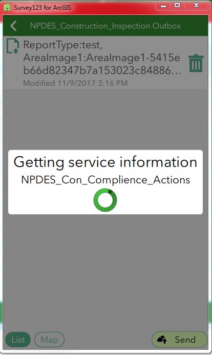
Hi I creates a survey and it looks good and all the questions are working properly. The issue is when I submit. The Getting Service Information just spins on the related table (repeat) I can access the table so its there and running.
Does anyone have any thoughts?
Thanks,
Matt
- Mark as New
- Bookmark
- Subscribe
- Mute
- Subscribe to RSS Feed
- Permalink
- Report Inappropriate Content
Are you using the most current version of the Survey123 app? If you're not, try logging out and then logging back in before submitting.
I suggest updating to the newest version, early versions were prone to the 'Getting Service Information' problem.
- Mark as New
- Bookmark
- Subscribe
- Mute
- Subscribe to RSS Feed
- Permalink
- Report Inappropriate Content
Seems to be the most recent. There isn’t anything new available from the App Store.
Thanks
Sent from my iPhone
- Mark as New
- Bookmark
- Subscribe
- Mute
- Subscribe to RSS Feed
- Permalink
- Report Inappropriate Content
Hi Matt,
Looking at the screenshot, you are using Survey123 on a Windows computer, yes? Was there any change in connectivity between the time Survey123 was open and you attempted to submit?
- Mark as New
- Bookmark
- Subscribe
- Mute
- Subscribe to RSS Feed
- Permalink
- Report Inappropriate Content
No I cleared off all Surveys and downloaded it again. I closed the app and reopened it a few times and I was on a WIFI connection but also tried in on LTE.
Also this issue is the same on IOS and windows. I just sent the screenshot from windows.
Thanks for the response.
Sent from my iPhone
- Mark as New
- Bookmark
- Subscribe
- Mute
- Subscribe to RSS Feed
- Permalink
- Report Inappropriate Content
Hi Matt,
Thanks for the info. What is occurring is that an error is occurring somewhere in the process of connecting and submitting to the feature service that is not being appropriately handles by the application. To understand precisely what the error is, we would need to record the the problem via a log file; this is easiest to do in Windows. General information on this is at Troubleshoot—Survey123 for ArcGIS | ArcGIS. Could I ask you to:
1) Open Survey123
2) At the gallery of surveys, click on the menu button and click on 'Settings'
3) Click on the 'Diagnostics' button on the bottom of the Settings Screen
4) Click on the switch to start logging - this will start writing a log file (ignore the 'loading' image in the screen- that's to indicate that Survey123 is scanning for AppStudio debugging environments.)
5) Go back and replicate the error
6) Once replicated, you can close Survey123 again. The log file will be at
C:\Users\<Your Username>\ArcGIS\AppStudio\Logs - could you reply with that file?
- Mark as New
- Bookmark
- Subscribe
- Mute
- Subscribe to RSS Feed
- Permalink
- Report Inappropriate Content
Hi James,
Thank you for getting back to me. Sorry it took a little while to respond. I got put on another project last week.
Here is the log that was generated.
Thanks,
Matt
- Mark as New
- Bookmark
- Subscribe
- Mute
- Subscribe to RSS Feed
- Permalink
- Report Inappropriate Content
Hi James,
How can i add an attachment. I tried dropping and dragging.
Thanks,
James Tedrick wrote:
Hi Matt,
Thanks for the info. What is occurring is that an error is occurring somewhere in the process of connecting and submitting to the feature service that is not being appropriately handles by the application. To understand precisely what the error is, we would need to record the the problem via a log file; this is easiest to do in Windows. General information on this is at Troubleshoot—Survey123 for ArcGIS | ArcGIS. Could I ask you to:
1) Open Survey123
2) At the gallery of surveys, click on the menu button and click on 'Settings'
3) Click on the 'Diagnostics' button on the bottom of the Settings Screen
4) Click on the switch to start logging - this will start writing a log file (ignore the 'loading' image in the screen- that's to indicate that Survey123 is scanning for AppStudio debugging environments.)
5) Go back and replicate the error
6) Once replicated, you can close Survey123 again. The log file will be at
C:\Users\<Your Username>\ArcGIS\AppStudio\Logs - could you reply with that file?
<14>1 2017-11-15T14:16:52Z USCLM3LT0009 Survey123forArcGIS 6408 - - $ Logging started: 2017-11-15T09:16:52
<14>1 2017-11-15T14:16:52Z USCLM3LT0009 Survey123forArcGIS 6408 - - $ Application Name: Survey123forArcGIS
<14>1 2017-11-15T14:16:52Z USCLM3LT0009 Survey123forArcGIS 6408 - - $ Application Version: 2.4.72
<14>1 2017-11-15T14:16:52Z USCLM3LT0009 Survey123forArcGIS 6408 - - $ Application File Path: C:/Users/cierim/Applications/ArcGIS/Survey123forArcGIS/Survey123forArcGIS.exe
<14>1 2017-11-15T14:16:52Z USCLM3LT0009 Survey123forArcGIS 6408 - - $ Application Directory Path: C:/Users/cierim/Applications/ArcGIS/Survey123forArcGIS
<14>1 2017-11-15T14:16:52Z USCLM3LT0009 Survey123forArcGIS 6408 - - $ AppFramework Version: 2.1.2
<14>1 2017-11-15T14:16:52Z USCLM3LT0009 Survey123forArcGIS 6408 - - $ Qt Version: 5.8.0
<14>1 2017-11-15T14:16:52Z USCLM3LT0009 Survey123forArcGIS 6408 - - $ Operating System: Windows 7 SP 1 (6.1)
<14>1 2017-11-15T14:16:52Z USCLM3LT0009 Survey123forArcGIS 6408 - - $ Operating System Type: windows
<14>1 2017-11-15T14:16:52Z USCLM3LT0009 Survey123forArcGIS 6408 - - $ Operating System Version: 7sp1
<14>1 2017-11-15T14:16:52Z USCLM3LT0009 Survey123forArcGIS 6408 - - $ Kernel Type: winnt
<14>1 2017-11-15T14:16:52Z USCLM3LT0009 Survey123forArcGIS 6408 - - $ Kernel Version: 6.1.7601
<14>1 2017-11-15T14:16:52Z USCLM3LT0009 Survey123forArcGIS 6408 - - $ Build ABI: i386-little_endian-ilp32
<14>1 2017-11-15T14:16:52Z USCLM3LT0009 Survey123forArcGIS 6408 - - $ Current CPU Architecture: x86_64
<14>1 2017-11-15T14:16:52Z USCLM3LT0009 Survey123forArcGIS 6408 - - $ Build CPU Architecture: i386
<14>1 2017-11-15T14:16:52Z USCLM3LT0009 Survey123forArcGIS 6408 - - $ SSL Library Version: OpenSSL 1.0.2g 1 Mar 2016
<14>1 2017-11-15T14:16:52Z USCLM3LT0009 Survey123forArcGIS 6408 - - $ Host name: USCLM3LT0009
<14>1 2017-11-15T14:16:52Z USCLM3LT0009 Survey123forArcGIS 6408 - - $ Domain name: na.aecomnet.com
<14>1 2017-11-15T14:16:52Z USCLM3LT0009 Survey123forArcGIS 6408 - - $ Default locale: en_US
<14>1 2017-11-15T14:16:52Z USCLM3LT0009 Survey123forArcGIS 6408 - - $ Release Type: store
<15>1 2017-11-15T14:17:01Z USCLM3LT0009 Survey123forArcGIS 6408 - [AppStudio@11205 category="qml" function="closePage" filename="Page.qml" line="162"] qml: backPage undefined
<12>1 2017-11-15T14:17:03Z USCLM3LT0009 Survey123forArcGIS 6408 - [AppStudio@11205 category="default"] libpng warning: iCCP: known incorrect sRGB profile
<12>1 2017-11-15T14:17:03Z USCLM3LT0009 Survey123forArcGIS 6408 - [AppStudio@11205 category="default"] libpng warning: iCCP: known incorrect sRGB profile
<12>1 2017-11-15T14:17:03Z USCLM3LT0009 Survey123forArcGIS 6408 - [AppStudio@11205 category="default"] libpng warning: iCCP: known incorrect sRGB profile
<12>1 2017-11-15T14:17:03Z USCLM3LT0009 Survey123forArcGIS 6408 - [AppStudio@11205 category="default"] libpng warning: iCCP: known incorrect sRGB profile
<12>1 2017-11-15T14:17:03Z USCLM3LT0009 Survey123forArcGIS 6408 - [AppStudio@11205 category="default"] libpng warning: iCCP: known incorrect sRGB profile
<15>1 2017-11-15T14:17:03Z USCLM3LT0009 Survey123forArcGIS 6408 - [AppStudio@11205 category="qml" function="read" filename="SurveyInfo.qml" line="68"] qml: surveyInfo: {
"serviceInfo": {
"itemId": "3668a32f33554a51a58cbfb997340abd",
"type": "Feature Service",
"url": "https://services8.arcgis.com/9DcCkxgoIscCej54/arcgis/rest/services/Survey123Testing_NPDES_Constructi..."
}
}
<15>1 2017-11-15T14:17:03Z USCLM3LT0009 Survey123forArcGIS 6408 - [AppStudio@11205 category="qml" function="updateMapPackages" filename="SurveyInfo.qml" line="88"] qml: Primary library path: C:/Users/cierim/ArcGIS/My Surveys/Maps
<12>1 2017-11-15T14:17:03Z USCLM3LT0009 Survey123forArcGIS 6408 - [AppStudio@11205 category="default"] QQmlExpression: Expression qrc:/qml/template/SurveyInfoPage.qml:204:20 depends on non-NOTIFYable properties:
<12>1 2017-11-15T14:17:03Z USCLM3LT0009 Survey123forArcGIS 6408 - [AppStudio@11205 category="default"] QQuickItem::resources
<12>1 2017-11-15T14:17:05Z USCLM3LT0009 Survey123forArcGIS 6408 - [AppStudio@11205 category="qml" function="metaValue" filename="XFormData.qml" line="1478"] qml: metaValue: Schema not ready
<15>1 2017-11-15T14:17:05Z USCLM3LT0009 Survey123forArcGIS 6408 - [AppStudio@11205 category="qml" function="onInstanceChanged" filename="XFormData.qml" line="75"] qml: Data editMode: 0
<15>1 2017-11-15T14:17:05Z USCLM3LT0009 Survey123forArcGIS 6408 - [AppStudio@11205 category="qml" function="onFeatureServiceInfoChanged" filename="XFormFeatureService.qml" line="612"] qml: featureServiceInfo: null
<15>1 2017-11-15T14:17:05Z USCLM3LT0009 Survey123forArcGIS 6408 - [AppStudio@11205 category="qml" function="read" filename="SurveyInfo.qml" line="68"] qml: surveyInfo: {
"serviceInfo": {
"itemId": "3668a32f33554a51a58cbfb997340abd",
"type": "Feature Service",
"url": "https://services8.arcgis.com/9DcCkxgoIscCej54/arcgis/rest/services/Survey123Testing_NPDES_Constructi..."
}
}
<15>1 2017-11-15T14:17:05Z USCLM3LT0009 Survey123forArcGIS 6408 - [AppStudio@11205 category="qml" function="updateMapPackages" filename="SurveyInfo.qml" line="88"] qml: Primary library path: C:/Users/cierim/ArcGIS/My Surveys/Maps
<12>1 2017-11-15T14:17:05Z USCLM3LT0009 Survey123forArcGIS 6408 - [AppStudio@11205 category="default"] libpng warning: iCCP: known incorrect sRGB profile
<12>1 2017-11-15T14:17:05Z USCLM3LT0009 Survey123forArcGIS 6408 - [AppStudio@11205 category="default"] libpng warning: iCCP: known incorrect sRGB profile
<12>1 2017-11-15T14:17:05Z USCLM3LT0009 Survey123forArcGIS 6408 - [AppStudio@11205 category="default"] libpng warning: iCCP: known incorrect sRGB profile
<15>1 2017-11-15T14:17:05Z USCLM3LT0009 Survey123forArcGIS 6408 - [AppStudio@11205 category="qml" function="onCompleted" filename="SurveysListPage.qml" line="83"] qml: SurveysListPage: C:/Users/cierim/ArcGIS/My Surveys/6270f5333bc1422aba7335876042cee9/esriinfo/NPDES_Construction_Inspection.xml
<15>1 2017-11-15T14:17:05Z USCLM3LT0009 Survey123forArcGIS 6408 - [AppStudio@11205 category="qml" function="update" filename="XFormSchema.qml" line="46"] qml: Update table schema: {
"#nodes": [
"submission",
"instance",
"bind[0]",
"bind[1]",
"bind[2]",
"bind[3]",
"bind[4]",
"bind[5]",
"bind[6]",
"bind[7]",
"bind[8]",
"bind[9]",
"bind[10]",
"bind[11]",
"bind[12]",
"bind[13]",
"bind[14]",
"bind[15]",
"bind[16]",
"bind[17]",
"bind[18]",
"bind[19]",
"bind[20]",
"bind[21]",
"bind[22]",
"bind[23]",
"bind[24]",
"bind[25]",
"bind[26]",
"bind[27]",
"bind[28]",
"bind[29]",
"bind[30]",
"bind[31]",
"bind[32]",
"bind[33]",
"bind[34]",
"bind[35]",
"bind[36]",
"bind[37]",
"bind[38]",
"bind[39]",
"bind[40]",
"bind[41]",
"bind[42]",
"bind[43]"
],
"bind": [
{
"@nodeset": "/NPDES_Construction_Inspection/geometry",
"@type": "geopoint"
},
{
"@esri:fieldLength": "50",
"@esri:fieldType": "esriFieldTypeString",
"@nodeset": "/NPDES_Construction_Inspection/ReportType",
"@type": "string"
},
{
"@esri:fieldLength": "50",
"@esri:fieldType": "esriFieldTypeString",
"@nodeset": "/NPDES_Construction_Inspection/ProjectName",
"@type": "string"
},
{
"@esri:fieldLength": "50",
"@esri:fieldType": "esriFieldTypeString",
"@nodeset": "/NPDES_Construction_Inspection/Permit_Number",
"@type": "string"
},
{
"@esri:fieldLength": "50",
"@esri:fieldType": "esriFieldTypeString",
"@nodeset": "/NPDES_Construction_Inspection/PermitteeName",
"@type": "string"
},
{
"@esri:fieldLength": "150",
"@esri:fieldType": "esriFieldTypeString",
"@nodeset": "/NPDES_Construction_Inspection/PermitteeAddress",
"@type": "string"
},
{
"@esri:fieldLength": "50",
"@esri:fieldType": "esriFieldTypeString",
"@nodeset": "/NPDES_Construction_Inspection/PermitteeCity",
"@type": "string"
},
{
"@esri:fieldLength": "50",
"@esri:fieldType": "esriFieldTypeString",
"@nodeset": "/NPDES_Construction_Inspection/PermitteeState",
"@type": "string"
},
{
"@esri:fieldLength": "50",
"@esri:fieldType": "esriFieldTypeString",
"@nodeset": "/NPDES_Construction_Inspection/PermitteeZip",
"@type": "string"
},
{
"@esri:fieldType": "esriFieldTypeDate",
"@nodeset": "/NPDES_Construction_Inspection/InspectionDate",
"@type": "dateTime"
},
{
"@esri:fieldLength": "50",
"@esri:fieldType": "esriFieldTypeString",
"@nodeset": "/NPDES_Construction_Inspection/InspectorName",
"@type": "string"
},
{
"@esri:fieldLength": "50",
"@esri:fieldType": "esriFieldTypeString",
"@nodeset": "/NPDES_Construction_Inspection/Qualifications",
"@type": "string"
},
{
"@esri:fieldLength": "50",
"@esri:fieldType": "esriFieldTypeString",
"@nodeset": "/NPDES_Construction_Inspection/Contact_Number",
"@type": "string"
},
{
"@esri:fieldType": "esriFieldTypeDate",
"@nodeset": "/NPDES_Construction_Inspection/LastInpsectionDate",
"@type": "dateTime"
},
{
"@esri:fieldLength": "50",
"@esri:fieldType": "esriFieldTypeString",
"@nodeset": "/NPDES_Construction_Inspection/Weather",
"@type": "string"
},
{
"@esri:fieldLength": "10",
"@esri:fieldType": "esriFieldTypeString",
"@nodeset": "/NPDES_Construction_Inspection/RefA",
"@type": "select1"
},
{
"@esri:fieldLength": "10",
"@esri:fieldType": "esriFieldTypeString",
"@nodeset": "/NPDES_Construction_Inspection/RefB",
"@type": "select1"
},
{
"@esri:fieldLength": "10",
"@esri:fieldType": "esriFieldTypeString",
"@nodeset": "/NPDES_Construction_Inspection/RefC",
"@type": "select1"
},
{
"@esri:fieldLength": "10",
"@esri:fieldType": "esriFieldTypeString",
"@nodeset": "/NPDES_Construction_Inspection/RefD",
"@type": "select1"
},
{
"@esri:fieldLength": "10",
"@esri:fieldType": "esriFieldTypeString",
"@nodeset": "/NPDES_Construction_Inspection/RefE",
"@type": "select1"
},
{
"@esri:fieldLength": "10",
"@esri:fieldType": "esriFieldTypeString",
"@nodeset": "/NPDES_Construction_Inspection/RefF",
"@type": "select1"
},
{
"@esri:fieldLength": "10",
"@esri:fieldType": "esriFieldTypeString",
"@nodeset": "/NPDES_Construction_Inspection/RefG",
"@type": "select1"
},
{
"@esri:fieldLength": "10",
"@esri:fieldType": "esriFieldTypeString",
"@nodeset": "/NPDES_Construction_Inspection/RefH",
"@type": "select1"
},
{
"@esri:fieldLength": "10",
"@esri:fieldType": "esriFieldTypeString",
"@nodeset": "/NPDES_Construction_Inspection/RefI",
"@type": "select1"
},
{
"@esri:fieldLength": "10",
"@esri:fieldType": "esriFieldTypeString",
"@nodeset": "/NPDES_Construction_Inspection/RefJ",
"@type": "select1"
},
{
"@esri:fieldLength": "10",
"@esri:fieldType": "esriFieldTypeString",
"@nodeset": "/NPDES_Construction_Inspection/RefK",
"@type": "select1"
},
{
"@esri:fieldLength": "10",
"@esri:fieldType": "esriFieldTypeString",
"@nodeset": "/NPDES_Construction_Inspection/RefL",
"@type": "select1"
},
{
"@esri:fieldLength": "10",
"@esri:fieldType": "esriFieldTypeString",
"@nodeset": "/NPDES_Construction_Inspection/RefM",
"@type": "select1"
},
{
"@esri:fieldLength": "10",
"@esri:fieldType": "esriFieldTypeString",
"@nodeset": "/NPDES_Construction_Inspection/RefN",
"@type": "select1"
},
{
"@esri:fieldLength": "10",
"@esri:fieldType": "esriFieldTypeString",
"@nodeset": "/NPDES_Construction_Inspection/RefO",
"@type": "select1"
},
{
"@esri:fieldLength": "10",
"@esri:fieldType": "esriFieldTypeString",
"@nodeset": "/NPDES_Construction_Inspection/RefP",
"@type": "select1"
},
{
"@esri:fieldLength": "10",
"@esri:fieldType": "esriFieldTypeString",
"@nodeset": "/NPDES_Construction_Inspection/RefQ",
"@type": "select1"
},
{
"@esri:fieldLength": "10",
"@esri:fieldType": "esriFieldTypeString",
"@nodeset": "/NPDES_Construction_Inspection/RefR",
"@type": "select1"
},
{
"@esri:fieldLength": "10",
"@esri:fieldType": "esriFieldTypeString",
"@nodeset": "/NPDES_Construction_Inspection/RefS",
"@type": "select1"
},
{
"@esri:fieldLength": "10",
"@esri:fieldType": "esriFieldTypeString",
"@nodeset": "/NPDES_Construction_Inspection/RefT",
"@type": "select1"
},
{
"@esri:fieldLength": "10",
"@esri:fieldType": "esriFieldTypeString",
"@nodeset": "/NPDES_Construction_Inspection/RefU",
"@type": "select1"
},
{
"@nodeset": "/NPDES_Construction_Inspection/AreaImage1",
"@type": "binary"
},
{
"@nodeset": "/NPDES_Construction_Inspection/AreaImage2",
"@type": "binary"
},
{
"@esri:fieldLength": "50",
"@esri:fieldType": "esriFieldTypeString",
"@nodeset": "/NPDES_Construction_Inspection/NPDES_Con_Complience_Actions/REFERENCE",
"@type": "string"
},
{
"@esri:fieldLength": "255",
"@esri:fieldType": "esriFieldTypeString",
"@nodeset": "/NPDES_Construction_Inspection/NPDES_Con_Complience_Actions/CORRECTIVE_ACTION",
"@type": "string"
},
{
"@esri:fieldLength": "255",
"@esri:fieldType": "esriFieldTypeString",
"@nodeset": "/NPDES_Construction_Inspection/NPDES_Con_Complience_Actions/CORRECT_ACT_ADDL_COMMENT",
"@type": "string"
},
{
"@esri:fieldType": "esriFieldTypeDate",
"@nodeset": "/NPDES_Construction_Inspection/NPDES_Con_Complience_Actions/DATEINSPECTED",
"@type": "dateTime"
},
{
"@esri:fieldType": "esriFieldTypeDate",
"@nodeset": "/NPDES_Construction_Inspection/NPDES_Con_Complience_Actions/DATECORRECTED",
"@type": "dateTime"
},
{
"@calculate": "concat('uuid:', uuid())",
"@nodeset": "/NPDES_Construction_Inspection/meta/instanceID",
"@readonly": "true()",
"@type": "string"
}
],
"instance": {
"#nodes": [
"NPDES_Construction_Inspection"
],
"NPDES_Construction_Inspection": {
"#nodes": [
"geometry",
"ReportType",
"ProjectName",
"Permit_Number",
"PermitteeName",
"PermitteeAddress",
"PermitteeCity",
"PermitteeState",
"PermitteeZip",
"InspectionDate",
"InspectorName",
"Qualifications",
"Contact_Number",
"LastInpsectionDate",
"Weather",
"RefA",
"RefB",
"RefC",
"RefD",
"RefE",
"RefF",
"RefG",
"RefH",
"RefI",
"RefJ",
"RefK",
"RefL",
"RefM",
"RefN",
"RefO",
"RefP",
"RefQ",
"RefR",
"RefS",
"RefT",
"RefU",
"AreaImage1",
"AreaImage2",
"NPDES_Con_Complience_Actions",
"meta"
],
"@id": "NPDES_Construction_Complience",
"AreaImage1": null,
"AreaImage2": null,
"Contact_Number": null,
"InspectionDate": null,
"InspectorName": null,
"LastInpsectionDate": null,
"NPDES_Con_Complience_Actions": {
"#nodes": [
"REFERENCE",
"CORRECTIVE_ACTION",
"CORRECT_ACT_ADDL_COMMENT",
"DATEINSPECTED",
"DATECORRECTED"
],
"@jr:template": "",
"CORRECTIVE_ACTION": null,
"CORRECT_ACT_ADDL_COMMENT": null,
"DATECORRECTED": null,
"DATEINSPECTED": null,
"REFERENCE": null
},
"Permit_Number": null,
"PermitteeAddress": null,
"PermitteeCity": null,
"PermitteeName": null,
"PermitteeState": null,
"PermitteeZip": null,
"ProjectName": null,
"Qualifications": null,
"RefA": null,
"RefB": null,
"RefC": null,
"RefD": null,
"RefE": null,
"RefF": null,
"RefG": null,
"RefH": null,
"RefI": null,
"RefJ": null,
"RefK": null,
"RefL": null,
"RefM": null,
"RefN": null,
"RefO": null,
"RefP": null,
"RefQ": null,
"RefR": null,
"RefS": null,
"RefT": null,
"RefU": null,
"ReportType": null,
"Weather": null,
"geometry": null,
"meta": {
"#nodes": [
"instanceID"
],
"instanceID": null
}
}
},
"submission": {
"@action": "https://www.arcgis.com/sharing/rest/content/items/3668a32f33554a51a58cbfb997340abd",
"@method": "form-data-post"
}
}
<15>1 2017-11-15T14:17:05Z USCLM3LT0009 Survey123forArcGIS 6408 - [AppStudio@11205 category="qml" function="update" filename="XFormSchema.qml" line="47"] qml: repeatNodesets: [
"/NPDES_Construction_Inspection/NPDES_Con_Complience_Actions"
]
<15>1 2017-11-15T14:17:05Z USCLM3LT0009 Survey123forArcGIS 6408 - [AppStudio@11205 category="qml" function="buildSchema" filename="XFormSchema.qml" line="76"] qml: buildSchema: instance: {
"#nodes": [
"geometry",
"ReportType",
"ProjectName",
"Permit_Number",
"PermitteeName",
"PermitteeAddress",
"PermitteeCity",
"PermitteeState",
"PermitteeZip",
"InspectionDate",
"InspectorName",
"Qualifications",
"Contact_Number",
"LastInpsectionDate",
"Weather",
"RefA",
"RefB",
"RefC",
"RefD",
"RefE",
"RefF",
"RefG",
"RefH",
"RefI",
"RefJ",
"RefK",
"RefL",
"RefM",
"RefN",
"RefO",
"RefP",
"RefQ",
"RefR",
"RefS",
"RefT",
"RefU",
"AreaImage1",
"AreaImage2",
"NPDES_Con_Complience_Actions",
"meta"
],
"@id": "NPDES_Construction_Complience",
"AreaImage1": null,
"AreaImage2": null,
"Contact_Number": null,
"InspectionDate": null,
"InspectorName": null,
"LastInpsectionDate": null,
"NPDES_Con_Complience_Actions": {
"#nodes": [
"REFERENCE",
"CORRECTIVE_ACTION",
"CORRECT_ACT_ADDL_COMMENT",
"DATEINSPECTED",
"DATECORRECTED"
],
"@jr:template": "",
"CORRECTIVE_ACTION": null,
"CORRECT_ACT_ADDL_COMMENT": null,
"DATECORRECTED": null,
"DATEINSPECTED": null,
"REFERENCE": null
},
"Permit_Number": null,
"PermitteeAddress": null,
"PermitteeCity": null,
"PermitteeName": null,
"PermitteeState": null,
"PermitteeZip": null,
"ProjectName": null,
"Qualifications": null,
"RefA": null,
"RefB": null,
"RefC": null,
"RefD": null,
"RefE": null,
"RefF": null,
"RefG": null,
"RefH": null,
"RefI": null,
"RefJ": null,
"RefK": null,
"RefL": null,
"RefM": null,
"RefN": null,
"RefO": null,
"RefP": null,
"RefQ": null,
"RefR": null,
"RefS": null,
"RefT": null,
"RefU": null,
"ReportType": null,
"Weather": null,
"geometry": null,
"meta": {
"#nodes": [
"instanceID"
],
"instanceID": null
},
"#tag": "NPDES_Construction_Inspection"
}
<15>1 2017-11-15T14:17:05Z USCLM3LT0009 Survey123forArcGIS 6408 - [AppStudio@11205 category="qml" function="buildSchema" filename="XFormSchema.qml" line="98"] qml: schema table: NPDES_Construction_Inspection nodeset: /NPDES_Construction_Inspection binding: {}
<15>1 2017-11-15T14:17:05Z USCLM3LT0009 Survey123forArcGIS 6408 - [AppStudio@11205 category="qml" function="buildSchema" filename="XFormSchema.qml" line="228"] qml: XFormSchema basic mode: geometry
<15>1 2017-11-15T14:17:05Z USCLM3LT0009 Survey123forArcGIS 6408 - [AppStudio@11205 category="qml" function="buildSchema" filename="XFormSchema.qml" line="228"] qml: XFormSchema basic mode: ReportType
<15>1 2017-11-15T14:17:05Z USCLM3LT0009 Survey123forArcGIS 6408 - [AppStudio@11205 category="qml" function="buildSchema" filename="XFormSchema.qml" line="228"] qml: XFormSchema basic mode: ProjectName
<15>1 2017-11-15T14:17:05Z USCLM3LT0009 Survey123forArcGIS 6408 - [AppStudio@11205 category="qml" function="buildSchema" filename="XFormSchema.qml" line="228"] qml: XFormSchema basic mode: Permit_Number
<15>1 2017-11-15T14:17:05Z USCLM3LT0009 Survey123forArcGIS 6408 - [AppStudio@11205 category="qml" function="buildSchema" filename="XFormSchema.qml" line="228"] qml: XFormSchema basic mode: PermitteeName
<15>1 2017-11-15T14:17:05Z USCLM3LT0009 Survey123forArcGIS 6408 - [AppStudio@11205 category="qml" function="buildSchema" filename="XFormSchema.qml" line="228"] qml: XFormSchema basic mode: PermitteeAddress
<15>1 2017-11-15T14:17:05Z USCLM3LT0009 Survey123forArcGIS 6408 - [AppStudio@11205 category="qml" function="buildSchema" filename="XFormSchema.qml" line="228"] qml: XFormSchema basic mode: PermitteeCity
<15>1 2017-11-15T14:17:05Z USCLM3LT0009 Survey123forArcGIS 6408 - [AppStudio@11205 category="qml" function="buildSchema" filename="XFormSchema.qml" line="228"] qml: XFormSchema basic mode: PermitteeState
<15>1 2017-11-15T14:17:05Z USCLM3LT0009 Survey123forArcGIS 6408 - [AppStudio@11205 category="qml" function="buildSchema" filename="XFormSchema.qml" line="228"] qml: XFormSchema basic mode: PermitteeZip
<15>1 2017-11-15T14:17:05Z USCLM3LT0009 Survey123forArcGIS 6408 - [AppStudio@11205 category="qml" function="buildSchema" filename="XFormSchema.qml" line="228"] qml: XFormSchema basic mode: InspectionDate
<15>1 2017-11-15T14:17:05Z USCLM3LT0009 Survey123forArcGIS 6408 - [AppStudio@11205 category="qml" function="buildSchema" filename="XFormSchema.qml" line="228"] qml: XFormSchema basic mode: InspectorName
<15>1 2017-11-15T14:17:05Z USCLM3LT0009 Survey123forArcGIS 6408 - [AppStudio@11205 category="qml" function="buildSchema" filename="XFormSchema.qml" line="228"] qml: XFormSchema basic mode: Qualifications
<15>1 2017-11-15T14:17:05Z USCLM3LT0009 Survey123forArcGIS 6408 - [AppStudio@11205 category="qml" function="buildSchema" filename="XFormSchema.qml" line="228"] qml: XFormSchema basic mode: Contact_Number
<15>1 2017-11-15T14:17:05Z USCLM3LT0009 Survey123forArcGIS 6408 - [AppStudio@11205 category="qml" function="buildSchema" filename="XFormSchema.qml" line="228"] qml: XFormSchema basic mode: LastInpsectionDate
<15>1 2017-11-15T14:17:05Z USCLM3LT0009 Survey123forArcGIS 6408 - [AppStudio@11205 category="qml" function="buildSchema" filename="XFormSchema.qml" line="228"] qml: XFormSchema basic mode: Weather
<15>1 2017-11-15T14:17:05Z USCLM3LT0009 Survey123forArcGIS 6408 - [AppStudio@11205 category="qml" function="buildSchema" filename="XFormSchema.qml" line="228"] qml: XFormSchema basic mode: RefA
<15>1 2017-11-15T14:17:05Z USCLM3LT0009 Survey123forArcGIS 6408 - [AppStudio@11205 category="qml" function="buildSchema" filename="XFormSchema.qml" line="228"] qml: XFormSchema basic mode: RefB
<15>1 2017-11-15T14:17:05Z USCLM3LT0009 Survey123forArcGIS 6408 - [AppStudio@11205 category="qml" function="buildSchema" filename="XFormSchema.qml" line="228"] qml: XFormSchema basic mode: RefC
<15>1 2017-11-15T14:17:05Z USCLM3LT0009 Survey123forArcGIS 6408 - [AppStudio@11205 category="qml" function="buildSchema" filename="XFormSchema.qml" line="228"] qml: XFormSchema basic mode: RefD
<15>1 2017-11-15T14:17:05Z USCLM3LT0009 Survey123forArcGIS 6408 - [AppStudio@11205 category="qml" function="buildSchema" filename="XFormSchema.qml" line="228"] qml: XFormSchema basic mode: RefE
<15>1 2017-11-15T14:17:05Z USCLM3LT0009 Survey123forArcGIS 6408 - [AppStudio@11205 category="qml" function="buildSchema" filename="XFormSchema.qml" line="228"] qml: XFormSchema basic mode: RefF
<15>1 2017-11-15T14:17:05Z USCLM3LT0009 Survey123forArcGIS 6408 - [AppStudio@11205 category="qml" function="buildSchema" filename="XFormSchema.qml" line="228"] qml: XFormSchema basic mode: RefG
<15>1 2017-11-15T14:17:05Z USCLM3LT0009 Survey123forArcGIS 6408 - [AppStudio@11205 category="qml" function="buildSchema" filename="XFormSchema.qml" line="228"] qml: XFormSchema basic mode: RefH
<15>1 2017-11-15T14:17:05Z USCLM3LT0009 Survey123forArcGIS 6408 - [AppStudio@11205 category="qml" function="buildSchema" filename="XFormSchema.qml" line="228"] qml: XFormSchema basic mode: RefI
<15>1 2017-11-15T14:17:05Z USCLM3LT0009 Survey123forArcGIS 6408 - [AppStudio@11205 category="qml" function="buildSchema" filename="XFormSchema.qml" line="228"] qml: XFormSchema basic mode: RefJ
<15>1 2017-11-15T14:17:05Z USCLM3LT0009 Survey123forArcGIS 6408 - [AppStudio@11205 category="qml" function="buildSchema" filename="XFormSchema.qml" line="228"] qml: XFormSchema basic mode: RefK
<15>1 2017-11-15T14:17:05Z USCLM3LT0009 Survey123forArcGIS 6408 - [AppStudio@11205 category="qml" function="buildSchema" filename="XFormSchema.qml" line="228"] qml: XFormSchema basic mode: RefL
<15>1 2017-11-15T14:17:05Z USCLM3LT0009 Survey123forArcGIS 6408 - [AppStudio@11205 category="qml" function="buildSchema" filename="XFormSchema.qml" line="228"] qml: XFormSchema basic mode: RefM
<15>1 2017-11-15T14:17:05Z USCLM3LT0009 Survey123forArcGIS 6408 - [AppStudio@11205 category="qml" function="buildSchema" filename="XFormSchema.qml" line="228"] qml: XFormSchema basic mode: RefN
<15>1 2017-11-15T14:17:05Z USCLM3LT0009 Survey123forArcGIS 6408 - [AppStudio@11205 category="qml" function="buildSchema" filename="XFormSchema.qml" line="228"] qml: XFormSchema basic mode: RefO
<15>1 2017-11-15T14:17:05Z USCLM3LT0009 Survey123forArcGIS 6408 - [AppStudio@11205 category="qml" function="buildSchema" filename="XFormSchema.qml" line="228"] qml: XFormSchema basic mode: RefP
<15>1 2017-11-15T14:17:05Z USCLM3LT0009 Survey123forArcGIS 6408 - [AppStudio@11205 category="qml" function="buildSchema" filename="XFormSchema.qml" line="228"] qml: XFormSchema basic mode: RefQ
<15>1 2017-11-15T14:17:05Z USCLM3LT0009 Survey123forArcGIS 6408 - [AppStudio@11205 category="qml" function="buildSchema" filename="XFormSchema.qml" line="228"] qml: XFormSchema basic mode: RefR
<15>1 2017-11-15T14:17:05Z USCLM3LT0009 Survey123forArcGIS 6408 - [AppStudio@11205 category="qml" function="buildSchema" filename="XFormSchema.qml" line="228"] qml: XFormSchema basic mode: RefS
<15>1 2017-11-15T14:17:05Z USCLM3LT0009 Survey123forArcGIS 6408 - [AppStudio@11205 category="qml" function="buildSchema" filename="XFormSchema.qml" line="228"] qml: XFormSchema basic mode: RefT
<15>1 2017-11-15T14:17:05Z USCLM3LT0009 Survey123forArcGIS 6408 - [AppStudio@11205 category="qml" function="buildSchema" filename="XFormSchema.qml" line="228"] qml: XFormSchema basic mode: RefU
<15>1 2017-11-15T14:17:05Z USCLM3LT0009 Survey123forArcGIS 6408 - [AppStudio@11205 category="qml" function="buildSchema" filename="XFormSchema.qml" line="228"] qml: XFormSchema basic mode: AreaImage1
<15>1 2017-11-15T14:17:05Z USCLM3LT0009 Survey123forArcGIS 6408 - [AppStudio@11205 category="qml" function="buildSchema" filename="XFormSchema.qml" line="228"] qml: XFormSchema basic mode: AreaImage2
<15>1 2017-11-15T14:17:05Z USCLM3LT0009 Survey123forArcGIS 6408 - [AppStudio@11205 category="qml" function="buildSchema" filename="XFormSchema.qml" line="76"] qml: buildSchema: instance: {
"#nodes": [
"REFERENCE",
"CORRECTIVE_ACTION",
"CORRECT_ACT_ADDL_COMMENT",
"DATEINSPECTED",
"DATECORRECTED"
],
"@jr:template": "",
"CORRECTIVE_ACTION": null,
"CORRECT_ACT_ADDL_COMMENT": null,
"DATECORRECTED": null,
"DATEINSPECTED": null,
"REFERENCE": null,
"#tag": "NPDES_Con_Complience_Actions"
}
<15>1 2017-11-15T14:17:05Z USCLM3LT0009 Survey123forArcGIS 6408 - [AppStudio@11205 category="qml" function="buildSchema" filename="XFormSchema.qml" line="98"] qml: schema table: NPDES_Con_Complience_Actions nodeset: /NPDES_Construction_Inspection/NPDES_Con_Complience_Actions binding: {}
<15>1 2017-11-15T14:17:05Z USCLM3LT0009 Survey123forArcGIS 6408 - [AppStudio@11205 category="qml" function="buildSchema" filename="XFormSchema.qml" line="228"] qml: XFormSchema basic mode: REFERENCE
<15>1 2017-11-15T14:17:05Z USCLM3LT0009 Survey123forArcGIS 6408 - [AppStudio@11205 category="qml" function="buildSchema" filename="XFormSchema.qml" line="228"] qml: XFormSchema basic mode: CORRECTIVE_ACTION
<15>1 2017-11-15T14:17:05Z USCLM3LT0009 Survey123forArcGIS 6408 - [AppStudio@11205 category="qml" function="buildSchema" filename="XFormSchema.qml" line="228"] qml: XFormSchema basic mode: CORRECT_ACT_ADDL_COMMENT
<15>1 2017-11-15T14:17:05Z USCLM3LT0009 Survey123forArcGIS 6408 - [AppStudio@11205 category="qml" function="buildSchema" filename="XFormSchema.qml" line="228"] qml: XFormSchema basic mode: DATEINSPECTED
<15>1 2017-11-15T14:17:05Z USCLM3LT0009 Survey123forArcGIS 6408 - [AppStudio@11205 category="qml" function="buildSchema" filename="XFormSchema.qml" line="228"] qml: XFormSchema basic mode: DATECORRECTED
<15>1 2017-11-15T14:17:05Z USCLM3LT0009 Survey123forArcGIS 6408 - [AppStudio@11205 category="qml" function="buildSchema" filename="XFormSchema.qml" line="76"] qml: buildSchema: instance: {
"#nodes": [
"instanceID"
],
"instanceID": null,
"#tag": "meta"
}
<15>1 2017-11-15T14:17:05Z USCLM3LT0009 Survey123forArcGIS 6408 - [AppStudio@11205 category="qml" function="buildSchema" filename="XFormSchema.qml" line="98"] qml: schema table: meta nodeset: /NPDES_Construction_Inspection/meta binding: {}
<15>1 2017-11-15T14:17:05Z USCLM3LT0009 Survey123forArcGIS 6408 - [AppStudio@11205 category="qml" function="buildSchema" filename="XFormSchema.qml" line="205"] qml: Skipping meta/instanceID /NPDES_Construction_Inspection/meta/instanceID
<15>1 2017-11-15T14:17:05Z USCLM3LT0009 Survey123forArcGIS 6408 - [AppStudio@11205 category="qml" function="update" filename="XFormSchema.qml" line="66"] qml: schema: {
"binding": {},
"domains": [],
"esriParameters": {},
"fields": [
{
"attachment": false,
"autoField": false,
"binding": {
"@nodeset": "/NPDES_Construction_Inspection/geometry",
"@type": "geopoint"
},
"defaultValue": "",
"esriFieldAlias": "geometry",
"esriFieldType": "esriFieldTypeGeometry",
"esriGeometryType": "esriGeometryPoint",
"esriParameters": {},
"length": 255,
"name": "geometry",
"nodeset": "/NPDES_Construction_Inspection/geometry",
"readonly": false,
"required": false,
"tableName": "NPDES_Construction_Inspection",
"type": "geopoint"
},
{
"attachment": false,
"autoField": false,
"binding": {
"@esri:fieldLength": "50",
"@esri:fieldType": "esriFieldTypeString",
"@nodeset": "/NPDES_Construction_Inspection/ReportType",
"@type": "string"
},
"defaultValue": "",
"esriFieldAlias": "ReportType",
"esriFieldType": "esriFieldTypeString",
"esriParameters": {},
"length": 50,
"name": "ReportType",
"nodeset": "/NPDES_Construction_Inspection/ReportType",
"readonly": false,
"required": false,
"tableName": "NPDES_Construction_Inspection",
"type": "string"
},
{
"attachment": false,
"autoField": false,
"binding": {
"@esri:fieldLength": "50",
"@esri:fieldType": "esriFieldTypeString",
"@nodeset": "/NPDES_Construction_Inspection/ProjectName",
"@type": "string"
},
"defaultValue": "",
"esriFieldAlias": "ProjectName",
"esriFieldType": "esriFieldTypeString",
"esriParameters": {},
"length": 50,
"name": "ProjectName",
"nodeset": "/NPDES_Construction_Inspection/ProjectName",
"readonly": false,
"required": false,
"tableName": "NPDES_Construction_Inspection",
"type": "string"
},
{
"attachment": false,
"autoField": false,
"binding": {
"@esri:fieldLength": "50",
"@esri:fieldType": "esriFieldTypeString",
"@nodeset": "/NPDES_Construction_Inspection/Permit_Number",
"@type": "string"
},
"defaultValue": "",
"esriFieldAlias": "Permit_Number",
"esriFieldType": "esriFieldTypeString",
"esriParameters": {},
"length": 50,
"name": "Permit_Number",
"nodeset": "/NPDES_Construction_Inspection/Permit_Number",
"readonly": false,
"required": false,
"tableName": "NPDES_Construction_Inspection",
"type": "string"
},
{
"attachment": false,
"autoField": false,
"binding": {
"@esri:fieldLength": "50",
"@esri:fieldType": "esriFieldTypeString",
"@nodeset": "/NPDES_Construction_Inspection/PermitteeName",
"@type": "string"
},
"defaultValue": "",
"esriFieldAlias": "PermitteeName",
"esriFieldType": "esriFieldTypeString",
"esriParameters": {},
"length": 50,
"name": "PermitteeName",
"nodeset": "/NPDES_Construction_Inspection/PermitteeName",
"readonly": false,
"required": false,
"tableName": "NPDES_Construction_Inspection",
"type": "string"
},
{
"attachment": false,
"autoField": false,
"binding": {
"@esri:fieldLength": "150",
"@esri:fieldType": "esriFieldTypeString",
"@nodeset": "/NPDES_Construction_Inspection/PermitteeAddress",
"@type": "string"
},
"defaultValue": "",
"esriFieldAlias": "PermitteeAddress",
"esriFieldType": "esriFieldTypeString",
"esriParameters": {},
"length": 150,
"name": "PermitteeAddress",
"nodeset": "/NPDES_Construction_Inspection/PermitteeAddress",
"readonly": false,
"required": false,
"tableName": "NPDES_Construction_Inspection",
"type": "string"
},
{
"attachment": false,
"autoField": false,
"binding": {
"@esri:fieldLength": "50",
"@esri:fieldType": "esriFieldTypeString",
"@nodeset": "/NPDES_Construction_Inspection/PermitteeCity",
"@type": "string"
},
"defaultValue": "",
"esriFieldAlias": "PermitteeCity",
"esriFieldType": "esriFieldTypeString",
"esriParameters": {},
"length": 50,
"name": "PermitteeCity",
"nodeset": "/NPDES_Construction_Inspection/PermitteeCity",
"readonly": false,
"required": false,
"tableName": "NPDES_Construction_Inspection",
"type": "string"
},
{
"attachment": false,
"autoField": false,
"binding": {
"@esri:fieldLength": "50",
"@esri:fieldType": "esriFieldTypeString",
"@nodeset": "/NPDES_Construction_Inspection/PermitteeState",
"@type": "string"
},
"defaultValue": "",
"esriFieldAlias": "PermitteeState",
"esriFieldType": "esriFieldTypeString",
"esriParameters": {},
"length": 50,
"name": "PermitteeState",
"nodeset": "/NPDES_Construction_Inspection/PermitteeState",
"readonly": false,
"required": false,
"tableName": "NPDES_Construction_Inspection",
"type": "string"
},
{
"attachment": false,
"autoField": false,
"binding": {
"@esri:fieldLength": "50",
"@esri:fieldType": "esriFieldTypeString",
"@nodeset": "/NPDES_Construction_Inspection/PermitteeZip",
"@type": "string"
},
"defaultValue": "",
"esriFieldAlias": "PermitteeZip",
"esriFieldType": "esriFieldTypeString",
"esriParameters": {},
"length": 50,
"name": "PermitteeZip",
"nodeset": "/NPDES_Construction_Inspection/PermitteeZip",
"readonly": false,
"required": false,
"tableName": "NPDES_Construction_Inspection",
"type": "string"
},
{
"attachment": false,
"autoField": false,
"binding": {
"@esri:fieldType": "esriFieldTypeDate",
"@nodeset": "/NPDES_Construction_Inspection/InspectionDate",
"@type": "dateTime"
},
"defaultValue": "",
"esriFieldAlias": "InspectionDate",
"esriFieldType": "esriFieldTypeDate",
"esriParameters": {},
"length": 255,
"name": "InspectionDate",
"nodeset": "/NPDES_Construction_Inspection/InspectionDate",
"readonly": false,
"required": false,
"tableName": "NPDES_Construction_Inspection",
"type": "dateTime"
},
{
"attachment": false,
"autoField": false,
"binding": {
"@esri:fieldLength": "50",
"@esri:fieldType": "esriFieldTypeString",
"@nodeset": "/NPDES_Construction_Inspection/InspectorName",
"@type": "string"
},
"defaultValue": "",
"esriFieldAlias": "InspectorName",
"esriFieldType": "esriFieldTypeString",
"esriParameters": {},
"length": 50,
"name": "InspectorName",
"nodeset": "/NPDES_Construction_Inspection/InspectorName",
"readonly": false,
"required": false,
"tableName": "NPDES_Construction_Inspection",
"type": "string"
},
{
"attachment": false,
"autoField": false,
"binding": {
"@esri:fieldLength": "50",
"@esri:fieldType": "esriFieldTypeString",
"@nodeset": "/NPDES_Construction_Inspection/Qualifications",
"@type": "string"
},
"defaultValue": "",
"esriFieldAlias": "Qualifications",
"esriFieldType": "esriFieldTypeString",
"esriParameters": {},
"length": 50,
"name": "Qualifications",
"nodeset": "/NPDES_Construction_Inspection/Qualifications",
"readonly": false,
"required": false,
"tableName": "NPDES_Construction_Inspection",
"type": "string"
},
{
"attachment": false,
"autoField": false,
"binding": {
"@esri:fieldLength": "50",
"@esri:fieldType": "esriFieldTypeString",
"@nodeset": "/NPDES_Construction_Inspection/Contact_Number",
"@type": "string"
},
"defaultValue": "",
"esriFieldAlias": "Contact_Number",
"esriFieldType": "esriFieldTypeString",
"esriParameters": {},
"length": 50,
"name": "Contact_Number",
"nodeset": "/NPDES_Construction_Inspection/Contact_Number",
"readonly": false,
"required": false,
"tableName": "NPDES_Construction_Inspection",
"type": "string"
},
{
"attachment": false,
"autoField": false,
"binding": {
"@esri:fieldType": "esriFieldTypeDate",
"@nodeset": "/NPDES_Construction_Inspection/LastInpsectionDate",
"@type": "dateTime"
},
"defaultValue": "",
"esriFieldAlias": "LastInpsectionDate",
"esriFieldType": "esriFieldTypeDate",
"esriParameters": {},
"length": 255,
"name": "LastInpsectionDate",
"nodeset": "/NPDES_Construction_Inspection/LastInpsectionDate",
"readonly": false,
"required": false,
"tableName": "NPDES_Construction_Inspection",
"type": "dateTime"
},
{
"attachment": false,
"autoField": false,
"binding": {
"@esri:fieldLength": "50",
"@esri:fieldType": "esriFieldTypeString",
"@nodeset": "/NPDES_Construction_Inspection/Weather",
"@type": "string"
},
"defaultValue": "",
"esriFieldAlias": "Weather",
"esriFieldType": "esriFieldTypeString",
"esriParameters": {},
"length": 50,
"name": "Weather",
"nodeset": "/NPDES_Construction_Inspection/Weather",
"readonly": false,
"required": false,
"tableName": "NPDES_Construction_Inspection",
"type": "string"
},
{
"attachment": false,
"autoField": false,
"binding": {
"@esri:fieldLength": "10",
"@esri:fieldType": "esriFieldTypeString",
"@nodeset": "/NPDES_Construction_Inspection/RefA",
"@type": "select1"
},
"defaultValue": "",
"esriFieldAlias": "RefA",
"esriFieldType": "esriFieldTypeString",
"esriParameters": {},
"length": 10,
"name": "RefA",
"nodeset": "/NPDES_Construction_Inspection/RefA",
"readonly": false,
"required": false,
"tableName": "NPDES_Construction_Inspection",
"type": "select1"
},
{
"attachment": false,
"autoField": false,
"binding": {
"@esri:fieldLength": "10",
"@esri:fieldType": "esriFieldTypeString",
"@nodeset": "/NPDES_Construction_Inspection/RefB",
"@type": "select1"
},
"defaultValue": "",
"esriFieldAlias": "RefB",
"esriFieldType": "esriFieldTypeString",
"esriParameters": {},
"length": 10,
"name": "RefB",
"nodeset": "/NPDES_Construction_Inspection/RefB",
"readonly": false,
"required": false,
"tableName": "NPDES_Construction_Inspection",
"type": "select1"
},
{
"attachment": false,
"autoField": false,
"binding": {
"@esri:fieldLength": "10",
"@esri:fieldType": "esriFieldTypeString",
"@nodeset": "/NPDES_Construction_Inspection/RefC",
"@type": "select1"
},
"defaultValue": "",
"esriFieldAlias": "RefC",
"esriFieldType": "esriFieldTypeString",
"esriParameters": {},
"length": 10,
"name": "RefC",
"nodeset": "/NPDES_Construction_Inspection/RefC",
"readonly": false,
"required": false,
"tableName": "NPDES_Construction_Inspection",
"type": "select1"
},
{
"attachment": false,
"autoField": false,
"binding": {
"@esri:fieldLength": "10",
"@esri:fieldType": "esriFieldTypeString",
"@nodeset": "/NPDES_Construction_Inspection/RefD",
"@type": "select1"
},
"defaultValue": "",
"esriFieldAlias": "RefD",
"esriFieldType": "esriFieldTypeString",
"esriParameters": {},
"length": 10,
"name": "RefD",
"nodeset": "/NPDES_Construction_Inspection/RefD",
"readonly": false,
"required": false,
"tableName": "NPDES_Construction_Inspection",
"type": "select1"
},
{
"attachment": false,
"autoField": false,
"binding": {
"@esri:fieldLength": "10",
"@esri:fieldType": "esriFieldTypeString",
"@nodeset": "/NPDES_Construction_Inspection/RefE",
"@type": "select1"
},
"defaultValue": "",
"esriFieldAlias": "RefE",
"esriFieldType": "esriFieldTypeString",
"esriParameters": {},
"length": 10,
"name": "RefE",
"nodeset": "/NPDES_Construction_Inspection/RefE",
"readonly": false,
"required": false,
"tableName": "NPDES_Construction_Inspection",
"type": "select1"
},
{
"attachment": false,
"autoField": false,
"binding": {
"@esri:fieldLength": "10",
"@esri:fieldType": "esriFieldTypeString",
"@nodeset": "/NPDES_Construction_Inspection/RefF",
"@type": "select1"
},
"defaultValue": "",
"esriFieldAlias": "RefF",
"esriFieldType": "esriFieldTypeString",
"esriParameters": {},
"length": 10,
"name": "RefF",
"nodeset": "/NPDES_Construction_Inspection/RefF",
"readonly": false,
"required": false,
"tableName": "NPDES_Construction_Inspection",
"type": "select1"
},
{
"attachment": false,
"autoField": false,
"binding": {
"@esri:fieldLength": "10",
"@esri:fieldType": "esriFieldTypeString",
"@nodeset": "/NPDES_Construction_Inspection/RefG",
"@type": "select1"
},
"defaultValue": "",
"esriFieldAlias": "RefG",
"esriFieldType": "esriFieldTypeString",
"esriParameters": {},
"length": 10,
"name": "RefG",
"nodeset": "/NPDES_Construction_Inspection/RefG",
"readonly": false,
"required": false,
"tableName": "NPDES_Construction_Inspection",
"type": "select1"
},
{
"attachment": false,
"autoField": false,
"binding": {
"@esri:fieldLength": "10",
"@esri:fieldType": "esriFieldTypeString",
"@nodeset": "/NPDES_Construction_Inspection/RefH",
"@type": "select1"
},
"defaultValue": "",
"esriFieldAlias": "RefH",
"esriFieldType": "esriFieldTypeString",
"esriParameters": {},
"length": 10,
"name": "RefH",
"nodeset": "/NPDES_Construction_Inspection/RefH",
"readonly": false,
"required": false,
"tableName": "NPDES_Construction_Inspection",
"type": "select1"
},
{
"attachment": false,
"autoField": false,
"binding": {
"@esri:fieldLength": "10",
"@esri:fieldType": "esriFieldTypeString",
"@nodeset": "/NPDES_Construction_Inspection/RefI",
"@type": "select1"
},
"defaultValue": "",
"esriFieldAlias": "RefI",
"esriFieldType": "esriFieldTypeString",
"esriParameters": {},
"length": 10,
"name": "RefI",
"nodeset": "/NPDES_Construction_Inspection/RefI",
"readonly": false,
"required": false,
"tableName": "NPDES_Construction_Inspection",
"type": "select1"
},
{
"attachment": false,
"autoField": false,
"binding": {
"@esri:fieldLength": "10",
"@esri:fieldType": "esriFieldTypeString",
"@nodeset": "/NPDES_Construction_Inspection/RefJ",
"@type": "select1"
},
"defaultValue": "",
"esriFieldAlias": "RefJ",
"esriFieldType": "esriFieldTypeString",
"esriParameters": {},
"length": 10,
"name": "RefJ",
"nodeset": "/NPDES_Construction_Inspection/RefJ",
"readonly": false,
"required": false,
"tableName": "NPDES_Construction_Inspection",
"type": "select1"
},
{
"attachment": false,
"autoField": false,
"binding": {
"@esri:fieldLength": "10",
"@esri:fieldType": "esriFieldTypeString",
"@nodeset": "/NPDES_Construction_Inspection/RefK",
"@type": "select1"
},
"defaultValue": "",
"esriFieldAlias": "RefK",
"esriFieldType": "esriFieldTypeString",
"esriParameters": {},
"length": 10,
"name": "RefK",
"nodeset": "/NPDES_Construction_Inspection/RefK",
"readonly": false,
"required": false,
"tableName": "NPDES_Construction_Inspection",
"type": "select1"
},
{
"attachment": false,
"autoField": false,
"binding": {
"@esri:fieldLength": "10",
"@esri:fieldType": "esriFieldTypeString",
"@nodeset": "/NPDES_Construction_Inspection/RefL",
"@type": "select1"
},
"defaultValue": "",
"esriFieldAlias": "RefL",
"esriFieldType": "esriFieldTypeString",
"esriParameters": {},
"length": 10,
"name": "RefL",
"nodeset": "/NPDES_Construction_Inspection/RefL",
"readonly": false,
"required": false,
"tableName": "NPDES_Construction_Inspection",
"type": "select1"
},
{
"attachment": false,
"autoField": false,
"binding": {
"@esri:fieldLength": "10",
"@esri:fieldType": "esriFieldTypeString",
"@nodeset": "/NPDES_Construction_Inspection/RefM",
"@type": "select1"
},
"defaultValue": "",
"esriFieldAlias": "RefM",
"esriFieldType": "esriFieldTypeString",
"esriParameters": {},
"length": 10,
"name": "RefM",
"nodeset": "/NPDES_Construction_Inspection/RefM",
"readonly": false,
"required": false,
"tableName": "NPDES_Construction_Inspection",
"type": "select1"
},
{
"attachment": false,
"autoField": false,
"binding": {
"@esri:fieldLength": "10",
"@esri:fieldType": "esriFieldTypeString",
"@nodeset": "/NPDES_Construction_Inspection/RefN",
"@type": "select1"
},
"defaultValue": "",
"esriFieldAlias": "RefN",
"esriFieldType": "esriFieldTypeString",
"esriParameters": {},
"length": 10,
"name": "RefN",
"nodeset": "/NPDES_Construction_Inspection/RefN",
"readonly": false,
"required": false,
"tableName": "NPDES_Construction_Inspection",
"type": "select1"
},
{
"attachment": false,
"autoField": false,
"binding": {
"@esri:fieldLength": "10",
"@esri:fieldType": "esriFieldTypeString",
"@nodeset": "/NPDES_Construction_Inspection/RefO",
"@type": "select1"
},
"defaultValue": "",
"esriFieldAlias": "RefO",
"esriFieldType": "esriFieldTypeString",
"esriParameters": {},
"length": 10,
"name": "RefO",
"nodeset": "/NPDES_Construction_Inspection/RefO",
"readonly": false,
"required": false,
"tableName": "NPDES_Construction_Inspection",
"type": "select1"
},
{
"attachment": false,
"autoField": false,
"binding": {
"@esri:fieldLength": "10",
"@esri:fieldType": "esriFieldTypeString",
"@nodeset": "/NPDES_Construction_Inspection/RefP",
"@type": "select1"
},
"defaultValue": "",
"esriFieldAlias": "RefP",
"esriFieldType": "esriFieldTypeString",
"esriParameters": {},
"length": 10,
"name": "RefP",
"nodeset": "/NPDES_Construction_Inspection/RefP",
"readonly": false,
"required": false,
"tableName": "NPDES_Construction_Inspection",
"type": "select1"
},
{
"attachment": false,
"autoField": false,
"binding": {
"@esri:fieldLength": "10",
"@esri:fieldType": "esriFieldTypeString",
"@nodeset": "/NPDES_Construction_Inspection/RefQ",
"@type": "select1"
},
"defaultValue": "",
"esriFieldAlias": "RefQ",
"esriFieldType": "esriFieldTypeString",
"esriParameters": {},
"length": 10,
"name": "RefQ",
"nodeset": "/NPDES_Construction_Inspection/RefQ",
"readonly": false,
"required": false,
"tableName": "NPDES_Construction_Inspection",
"type": "select1"
},
{
"attachment": false,
"autoField": false,
"binding": {
"@esri:fieldLength": "10",
"@esri:fieldType": "esriFieldTypeString",
"@nodeset": "/NPDES_Construction_Inspection/RefR",
"@type": "select1"
},
"defaultValue": "",
"esriFieldAlias": "RefR",
"esriFieldType": "esriFieldTypeString",
"esriParameters": {},
"length": 10,
"name": "RefR",
"nodeset": "/NPDES_Construction_Inspection/RefR",
"readonly": false,
"required": false,
"tableName": "NPDES_Construction_Inspection",
"type": "select1"
},
{
"attachment": false,
"autoField": false,
"binding": {
"@esri:fieldLength": "10",
"@esri:fieldType": "esriFieldTypeString",
"@nodeset": "/NPDES_Construction_Inspection/RefS",
"@type": "select1"
},
"defaultValue": "",
"esriFieldAlias": "RefS",
"esriFieldType": "esriFieldTypeString",
"esriParameters": {},
"length": 10,
"name": "RefS",
"nodeset": "/NPDES_Construction_Inspection/RefS",
"readonly": false,
"required": false,
"tableName": "NPDES_Construction_Inspection",
"type": "select1"
},
{
"attachment": false,
"autoField": false,
"binding": {
"@esri:fieldLength": "10",
"@esri:fieldType": "esriFieldTypeString",
"@nodeset": "/NPDES_Construction_Inspection/RefT",
"@type": "select1"
},
"defaultValue": "",
"esriFieldAlias": "RefT",
"esriFieldType": "esriFieldTypeString",
"esriParameters": {},
"length": 10,
"name": "RefT",
"nodeset": "/NPDES_Construction_Inspection/RefT",
"readonly": false,
"required": false,
"tableName": "NPDES_Construction_Inspection",
"type": "select1"
},
{
"attachment": false,
"autoField": false,
"binding": {
"@esri:fieldLength": "10",
"@esri:fieldType": "esriFieldTypeString",
"@nodeset": "/NPDES_Construction_Inspection/RefU",
"@type": "select1"
},
"defaultValue": "",
"esriFieldAlias": "RefU",
"esriFieldType": "esriFieldTypeString",
"esriParameters": {},
"length": 10,
"name": "RefU",
"nodeset": "/NPDES_Construction_Inspection/RefU",
"readonly": false,
"required": false,
"tableName": "NPDES_Construction_Inspection",
"type": "select1"
},
{
"attachment": true,
"autoField": false,
"binding": {
"@nodeset": "/NPDES_Construction_Inspection/AreaImage1",
"@type": "binary"
},
"defaultValue": "",
"esriFieldAlias": "AreaImage1",
"esriFieldType": "<attachment>",
"esriParameters": {},
"length": 255,
"name": "AreaImage1",
"nodeset": "/NPDES_Construction_Inspection/AreaImage1",
"readonly": false,
"required": false,
"tableName": "NPDES_Construction_Inspection",
"type": "binary"
},
{
"attachment": true,
"autoField": false,
"binding": {
"@nodeset": "/NPDES_Construction_Inspection/AreaImage2",
"@type": "binary"
},
"defaultValue": "",
"esriFieldAlias": "AreaImage2",
"esriFieldType": "<attachment>",
"esriParameters": {},
"length": 255,
"name": "AreaImage2",
"nodeset": "/NPDES_Construction_Inspection/AreaImage2",
"readonly": false,
"required": false,
"tableName": "NPDES_Construction_Inspection",
"type": "binary"
}
],
"fieldsRef": {
"geometry": {
"attachment": false,
"autoField": false,
"binding": {
"@nodeset": "/NPDES_Construction_Inspection/geometry",
"@type": "geopoint"
},
"defaultValue": "",
"esriFieldAlias": "geometry",
"esriFieldType": "esriFieldTypeGeometry",
"esriGeometryType": "esriGeometryPoint",
"esriParameters": {},
"length": 255,
"name": "geometry",
"nodeset": "/NPDES_Construction_Inspection/geometry",
"readonly": false,
"required": false,
"tableName": "NPDES_Construction_Inspection",
"type": "geopoint"
},
"ReportType": {
"attachment": false,
"autoField": false,
"binding": {
"@esri:fieldLength": "50",
"@esri:fieldType": "esriFieldTypeString",
"@nodeset": "/NPDES_Construction_Inspection/ReportType",
"@type": "string"
},
"defaultValue": "",
"esriFieldAlias": "ReportType",
"esriFieldType": "esriFieldTypeString",
"esriParameters": {},
"length": 50,
"name": "ReportType",
"nodeset": "/NPDES_Construction_Inspection/ReportType",
"readonly": false,
"required": false,
"tableName": "NPDES_Construction_Inspection",
"type": "string"
},
"ProjectName": {
"attachment": false,
"autoField": false,
"binding": {
"@esri:fieldLength": "50",
"@esri:fieldType": "esriFieldTypeString",
"@nodeset": "/NPDES_Construction_Inspection/ProjectName",
"@type": "string"
},
"defaultValue": "",
"esriFieldAlias": "ProjectName",
"esriFieldType": "esriFieldTypeString",
"esriParameters": {},
"length": 50,
"name": "ProjectName",
"nodeset": "/NPDES_Construction_Inspection/ProjectName",
"readonly": false,
"required": false,
"tableName": "NPDES_Construction_Inspection",
"type": "string"
},
"Permit_Number": {
"attachment": false,
"autoField": false,
"binding": {
"@esri:fieldLength": "50",
"@esri:fieldType": "esriFieldTypeString",
"@nodeset": "/NPDES_Construction_Inspection/Permit_Number",
"@type": "string"
},
"defaultValue": "",
"esriFieldAlias": "Permit_Number",
"esriFieldType": "esriFieldTypeString",
"esriParameters": {},
"length": 50,
"name": "Permit_Number",
"nodeset": "/NPDES_Construction_Inspection/Permit_Number",
"readonly": false,
"required": false,
"tableName": "NPDES_Construction_Inspection",
"type": "string"
},
"PermitteeName": {
"attachment": false,
"autoField": false,
"binding": {
"@esri:fieldLength": "50",
"@esri:fieldType": "esriFieldTypeString",
"@nodeset": "/NPDES_Construction_Inspection/PermitteeName",
"@type": "string"
},
"defaultValue": "",
"esriFieldAlias": "PermitteeName",
"esriFieldType": "esriFieldTypeString",
"esriParameters": {},
"length": 50,
"name": "PermitteeName",
"nodeset": "/NPDES_Construction_Inspection/PermitteeName",
"readonly": false,
"required": false,
"tableName": "NPDES_Construction_Inspection",
"type": "string"
},
"PermitteeAddress": {
"attachment": false,
"autoField": false,
"binding": {
"@esri:fieldLength": "150",
"@esri:fieldType": "esriFieldTypeString",
"@nodeset": "/NPDES_Construction_Inspection/PermitteeAddress",
"@type": "string"
},
"defaultValue": "",
"esriFieldAlias": "PermitteeAddress",
"esriFieldType": "esriFieldTypeString",
"esriParameters": {},
"length": 150,
"name": "PermitteeAddress",
"nodeset": "/NPDES_Construction_Inspection/PermitteeAddress",
"readonly": false,
"required": false,
"tableName": "NPDES_Construction_Inspection",
"type": "string"
},
"PermitteeCity": {
"attachment": false,
"autoField": false,
"binding": {
"@esri:fieldLength": "50",
"@esri:fieldType": "esriFieldTypeString",
"@nodeset": "/NPDES_Construction_Inspection/PermitteeCity",
"@type": "string"
},
"defaultValue": "",
"esriFieldAlias": "PermitteeCity",
"esriFieldType": "esriFieldTypeString",
"esriParameters": {},
"length": 50,
"name": "PermitteeCity",
"nodeset": "/NPDES_Construction_Inspection/PermitteeCity",
"readonly": false,
"required": false,
"tableName": "NPDES_Construction_Inspection",
"type": "string"
},
"PermitteeState": {
"attachment": false,
"autoField": false,
"binding": {
"@esri:fieldLength": "50",
"@esri:fieldType": "esriFieldTypeString",
"@nodeset": "/NPDES_Construction_Inspection/PermitteeState",
"@type": "string"
},
"defaultValue": "",
"esriFieldAlias": "PermitteeState",
"esriFieldType": "esriFieldTypeString",
"esriParameters": {},
"length": 50,
"name": "PermitteeState",
"nodeset": "/NPDES_Construction_Inspection/PermitteeState",
"readonly": false,
"required": false,
"tableName": "NPDES_Construction_Inspection",
"type": "string"
},
"PermitteeZip": {
"attachment": false,
"autoField": false,
"binding": {
"@esri:fieldLength": "50",
"@esri:fieldType": "esriFieldTypeString",
"@nodeset": "/NPDES_Construction_Inspection/PermitteeZip",
"@type": "string"
},
"defaultValue": "",
"esriFieldAlias": "PermitteeZip",
"esriFieldType": "esriFieldTypeString",
"esriParameters": {},
"length": 50,
"name": "PermitteeZip",
"nodeset": "/NPDES_Construction_Inspection/PermitteeZip",
"readonly": false,
"required": false,
"tableName": "NPDES_Construction_Inspection",
"type": "string"
},
"InspectionDate": {
"attachment": false,
"autoField": false,
"binding": {
"@esri:fieldType": "esriFieldTypeDate",
"@nodeset": "/NPDES_Construction_Inspection/InspectionDate",
"@type": "dateTime"
},
"defaultValue": "",
"esriFieldAlias": "InspectionDate",
"esriFieldType": "esriFieldTypeDate",
"esriParameters": {},
"length": 255,
"name": "InspectionDate",
"nodeset": "/NPDES_Construction_Inspection/InspectionDate",
"readonly": false,
"required": false,
"tableName": "NPDES_Construction_Inspection",
"type": "dateTime"
},
"InspectorName": {
"attachment": false,
"autoField": false,
"binding": {
"@esri:fieldLength": "50",
"@esri:fieldType": "esriFieldTypeString",
"@nodeset": "/NPDES_Construction_Inspection/InspectorName",
"@type": "string"
},
"defaultValue": "",
"esriFieldAlias": "InspectorName",
"esriFieldType": "esriFieldTypeString",
"esriParameters": {},
"length": 50,
"name": "InspectorName",
"nodeset": "/NPDES_Construction_Inspection/InspectorName",
"readonly": false,
"required": false,
"tableName": "NPDES_Construction_Inspection",
"type": "string"
},
"Qualifications": {
"attachment": false,
"autoField": false,
"binding": {
"@esri:fieldLength": "50",
"@esri:fieldType": "esriFieldTypeString",
"@nodeset": "/NPDES_Construction_Inspection/Qualifications",
"@type": "string"
},
"defaultValue": "",
"esriFieldAlias": "Qualifications",
"esriFieldType": "esriFieldTypeString",
"esriParameters": {},
"length": 50,
"name": "Qualifications",
"nodeset": "/NPDES_Construction_Inspection/Qualifications",
"readonly": false,
"required": false,
"tableName": "NPDES_Construction_Inspection",
"type": "string"
},
"Contact_Number": {
"attachment": false,
"autoField": false,
"binding": {
"@esri:fieldLength": "50",
"@esri:fieldType": "esriFieldTypeString",
"@nodeset": "/NPDES_Construction_Inspection/Contact_Number",
"@type": "string"
},
"defaultValue": "",
"esriFieldAlias": "Contact_Number",
"esriFieldType": "esriFieldTypeString",
"esriParameters": {},
"length": 50,
"name": "Contact_Number",
"nodeset": "/NPDES_Construction_Inspection/Contact_Number",
"readonly": false,
"required": false,
"tableName": "NPDES_Construction_Inspection",
"type": "string"
},
"LastInpsectionDate": {
"attachment": false,
"autoField": false,
"binding": {
"@esri:fieldType": "esriFieldTypeDate",
"@nodeset": "/NPDES_Construction_Inspection/LastInpsectionDate",
"@type": "dateTime"
},
"defaultValue": "",
"esriFieldAlias": "LastInpsectionDate",
"esriFieldType": "esriFieldTypeDate",
"esriParameters": {},
"length": 255,
"name": "LastInpsectionDate",
"nodeset": "/NPDES_Construction_Inspection/LastInpsectionDate",
"readonly": false,
"required": false,
"tableName": "NPDES_Construction_Inspection",
"type": "dateTime"
},
"Weather": {
"attachment": false,
"autoField": false,
"binding": {
"@esri:fieldLength": "50",
"@esri:fieldType": "esriFieldTypeString",
"@nodeset": "/NPDES_Construction_Inspection/Weather",
"@type": "string"
},
"defaultValue": "",
"esriFieldAlias": "Weather",
"esriFieldType": "esriFieldTypeString",
"esriParameters": {},
"length": 50,
"name": "Weather",
"nodeset": "/NPDES_Construction_Inspection/Weather",
"readonly": false,
"required": false,
"tableName": "NPDES_Construction_Inspection",
"type": "string"
},
"RefA": {
"attachment": false,
"autoField": false,
"binding": {
"@esri:fieldLength": "10",
"@esri:fieldType": "esriFieldTypeString",
"@nodeset": "/NPDES_Construction_Inspection/RefA",
"@type": "select1"
},
"defaultValue": "",
"esriFieldAlias": "RefA",
"esriFieldType": "esriFieldTypeString",
"esriParameters": {},
"length": 10,
"name": "RefA",
"nodeset": "/NPDES_Construction_Inspection/RefA",
"readonly": false,
"required": false,
"tableName": "NPDES_Construction_Inspection",
"type": "select1"
},
"RefB": {
"attachment": false,
"autoField": false,
"binding": {
"@esri:fieldLength": "10",
"@esri:fieldType": "esriFieldTypeString",
"@nodeset": "/NPDES_Construction_Inspection/RefB",
"@type": "select1"
},
"defaultValue": "",
"esriFieldAlias": "RefB",
"esriFieldType": "esriFieldTypeString",
"esriParameters": {},
"length": 10,
"name": "RefB",
"nodeset": "/NPDES_Construction_Inspection/RefB",
"readonly": false,
"required": false,
"tableName": "NPDES_Construction_Inspection",
"type": "select1"
},
"RefC": {
"attachment": false,
"autoField": false,
"binding": {
"@esri:fieldLength": "10",
"@esri:fieldType": "esriFieldTypeString",
"@nodeset": "/NPDES_Construction_Inspection/RefC",
"@type": "select1"
},
"defaultValue": "",
"esriFieldAlias": "RefC",
"esriFieldType": "esriFieldTypeString",
"esriParameters": {},
"length": 10,
"name": "RefC",
"nodeset": "/NPDES_Construction_Inspection/RefC",
"readonly": false,
"required": false,
"tableName": "NPDES_Construction_Inspection",
"type": "select1"
},
"RefD": {
"attachment": false,
"autoField": false,
"binding": {
"@esri:fieldLength": "10",
"@esri:fieldType": "esriFieldTypeString",
"@nodeset": "/NPDES_Construction_Inspection/RefD",
"@type": "select1"
},
"defaultValue": "",
"esriFieldAlias": "RefD",
"esriFieldType": "esriFieldTypeString",
"esriParameters": {},
"length": 10,
"name": "RefD",
"nodeset": "/NPDES_Construction_Inspection/RefD",
"readonly": false,
"required": false,
"tableName": "NPDES_Construction_Inspection",
"type": "select1"
},
"RefE": {
"attachment": false,
"autoField": false,
"binding": {
"@esri:fieldLength": "10",
"@esri:fieldType": "esriFieldTypeString",
"@nodeset": "/NPDES_Construction_Inspection/RefE",
"@type": "select1"
},
"defaultValue": "",
"esriFieldAlias": "RefE",
"esriFieldType": "esriFieldTypeString",
"esriParameters": {},
"length": 10,
"name": "RefE",
"nodeset": "/NPDES_Construction_Inspection/RefE",
"readonly": false,
"required": false,
"tableName": "NPDES_Construction_Inspection",
"type": "select1"
},
"RefF": {
"attachment": false,
"autoField": false,
"binding": {
"@esri:fieldLength": "10",
"@esri:fieldType": "esriFieldTypeString",
"@nodeset": "/NPDES_Construction_Inspection/RefF",
"@type": "select1"
},
"defaultValue": "",
"esriFieldAlias": "RefF",
"esriFieldType": "esriFieldTypeString",
"esriParameters": {},
"length": 10,
"name": "RefF",
"nodeset": "/NPDES_Construction_Inspection/RefF",
"readonly": false,
"required": false,
"tableName": "NPDES_Construction_Inspection",
"type": "select1"
},
"RefG": {
"attachment": false,
"autoField": false,
"binding": {
"@esri:fieldLength": "10",
"@esri:fieldType": "esriFieldTypeString",
"@nodeset": "/NPDES_Construction_Inspection/RefG",
"@type": "select1"
},
"defaultValue": "",
"esriFieldAlias": "RefG",
"esriFieldType": "esriFieldTypeString",
"esriParameters": {},
"length": 10,
"name": "RefG",
"nodeset": "/NPDES_Construction_Inspection/RefG",
"readonly": false,
"required": false,
"tableName": "NPDES_Construction_Inspection",
"type": "select1"
},
"RefH": {
"attachment": false,
"autoField": false,
"binding": {
"@esri:fieldLength": "10",
"@esri:fieldType": "esriFieldTypeString",
"@nodeset": "/NPDES_Construction_Inspection/RefH",
"@type": "select1"
},
"defaultValue": "",
"esriFieldAlias": "RefH",
"esriFieldType": "esriFieldTypeString",
"esriParameters": {},
"length": 10,
"name": "RefH",
"nodeset": "/NPDES_Construction_Inspection/RefH",
"readonly": false,
"required": false,
"tableName": "NPDES_Construction_Inspection",
"type": "select1"
},
"RefI": {
"attachment": false,
"autoField": false,
"binding": {
"@esri:fieldLength": "10",
"@esri:fieldType": "esriFieldTypeString",
"@nodeset": "/NPDES_Construction_Inspection/RefI",
"@type": "select1"
},
"defaultValue": "",
"esriFieldAlias": "RefI",
"esriFieldType": "esriFieldTypeString",
"esriParameters": {},
"length": 10,
"name": "RefI",
"nodeset": "/NPDES_Construction_Inspection/RefI",
"readonly": false,
"required": false,
"tableName": "NPDES_Construction_Inspection",
"type": "select1"
},
"RefJ": {
"attachment": false,
"autoField": false,
"binding": {
"@esri:fieldLength": "10",
"@esri:fieldType": "esriFieldTypeString",
"@nodeset": "/NPDES_Construction_Inspection/RefJ",
"@type": "select1"
},
"defaultValue": "",
"esriFieldAlias": "RefJ",
"esriFieldType": "esriFieldTypeString",
"esriParameters": {},
"length": 10,
"name": "RefJ",
"nodeset": "/NPDES_Construction_Inspection/RefJ",
"readonly": false,
"required": false,
"tableName": "NPDES_Construction_Inspection",
"type": "select1"
},
"RefK": {
"attachment": false,
"autoField": false,
"binding": {
"@esri:fieldLength": "10",
"@esri:fieldType": "esriFieldTypeString",
"@nodeset": "/NPDES_Construction_Inspection/RefK",
"@type": "select1"
},
"defaultValue": "",
"esriFieldAlias": "RefK",
"esriFieldType": "esriFieldTypeString",
"esriParameters": {},
"length": 10,
"name": "RefK",
"nodeset": "/NPDES_Construction_Inspection/RefK",
"readonly": false,
"required": false,
"tableName": "NPDES_Construction_Inspection",
"type": "select1"
},
"RefL": {
"attachment": false,
"autoField": false,
"binding": {
"@esri:fieldLength": "10",
"@esri:fieldType": "esriFieldTypeString",
"@nodeset": "/NPDES_Construction_Inspection/RefL",
"@type": "select1"
},
"defaultValue": "",
"esriFieldAlias": "RefL",
"esriFieldType": "esriFieldTypeString",
"esriParameters": {},
"length": 10,
"name": "RefL",
"nodeset": "/NPDES_Construction_Inspection/RefL",
"readonly": false,
"required": false,
"tableName": "NPDES_Construction_Inspection",
"type": "select1"
},
"RefM": {
"attachment": false,
"autoField": false,
"binding": {
"@esri:fieldLength": "10",
"@esri:fieldType": "esriFieldTypeString",
"@nodeset": "/NPDES_Construction_Inspection/RefM",
"@type": "select1"
},
"defaultValue": "",
"esriFieldAlias": "RefM",
"esriFieldType": "esriFieldTypeString",
"esriParameters": {},
"length": 10,
"name": "RefM",
"nodeset": "/NPDES_Construction_Inspection/RefM",
"readonly": false,
"required": false,
"tableName": "NPDES_Construction_Inspection",
"type": "select1"
},
"RefN": {
"attachment": false,
"autoField": false,
"binding": {
"@esri:fieldLength": "10",
"@esri:fieldType": "esriFieldTypeString",
"@nodeset": "/NPDES_Construction_Inspection/RefN",
"@type": "select1"
},
"defaultValue": "",
"esriFieldAlias": "RefN",
"esriFieldType": "esriFieldTypeString",
"esriParameters": {},
"length": 10,
"name": "RefN",
"nodeset": "/NPDES_Construction_Inspection/RefN",
"readonly": false,
"required": false,
"tableName": "NPDES_Construction_Inspection",
"type": "select1"
},
"RefO": {
"attachment": false,
"autoField": false,
"binding": {
"@esri:fieldLength": "10",
"@esri:fieldType": "esriFieldTypeString",
"@nodeset": "/NPDES_Construction_Inspection/RefO",
"@type": "select1"
},
"defaultValue": "",
"esriFieldAlias": "RefO",
"esriFieldType": "esriFieldTypeString",
"esriParameters": {},
"length": 10,
"name": "RefO",
"nodeset": "/NPDES_Construction_Inspection/RefO",
"readonly": false,
"required": false,
"tableName": "NPDES_Construction_Inspection",
"type": "select1"
},
"RefP": {
"attachment": false,
"autoField": false,
"binding": {
"@esri:fieldLength": "10",
"@esri:fieldType": "esriFieldTypeString",
"@nodeset": "/NPDES_Construction_Inspection/RefP",
"@type": "select1"
},
"defaultValue": "",
"esriFieldAlias": "RefP",
"esriFieldType": "esriFieldTypeString",
"esriParameters": {},
"length": 10,
"name": "RefP",
"nodeset": "/NPDES_Construction_Inspection/RefP",
"readonly": false,
"required": false,
"tableName": "NPDES_Construction_Inspection",
"type": "select1"
},
"RefQ": {
"attachment": false,
"autoField": false,
"binding": {
"@esri:fieldLength": "10",
"@esri:fieldType": "esriFieldTypeString",
"@nodeset": "/NPDES_Construction_Inspection/RefQ",
"@type": "select1"
},
"defaultValue": "",
"esriFieldAlias": "RefQ",
"esriFieldType": "esriFieldTypeString",
"esriParameters": {},
"length": 10,
"name": "RefQ",
"nodeset": "/NPDES_Construction_Inspection/RefQ",
"readonly": false,
"required": false,
"tableName": "NPDES_Construction_Inspection",
"type": "select1"
},
"RefR": {
"attachment": false,
"autoField": false,
"binding": {
"@esri:fieldLength": "10",
"@esri:fieldType": "esriFieldTypeString",
"@nodeset": "/NPDES_Construction_Inspection/RefR",
"@type": "select1"
},
"defaultValue": "",
"esriFieldAlias": "RefR",
"esriFieldType": "esriFieldTypeString",
"esriParameters": {},
"length": 10,
"name": "RefR",
"nodeset": "/NPDES_Construction_Inspection/RefR",
"readonly": false,
"required": false,
"tableName": "NPDES_Construction_Inspection",
"type": "select1"
},
"RefS": {
"attachment": false,
"autoField": false,
"binding": {
"@esri:fieldLength": "10",
"@esri:fieldType": "esriFieldTypeString",
"@nodeset": "/NPDES_Construction_Inspection/RefS",
"@type": "select1"
},
"defaultValue": "",
"esriFieldAlias": "RefS",
"esriFieldType": "esriFieldTypeString",
"esriParameters": {},
"length": 10,
"name": "RefS",
"nodeset": "/NPDES_Construction_Inspection/RefS",
"readonly": false,
"required": false,
"tableName": "NPDES_Construction_Inspection",
"type": "select1"
},
"RefT": {
"attachment": false,
"autoField": false,
"binding": {
"@esri:fieldLength": "10",
"@esri:fieldType": "esriFieldTypeString",
"@nodeset": "/NPDES_Construction_Inspection/RefT",
"@type": "select1"
},
"defaultValue": "",
"esriFieldAlias": "RefT",
"esriFieldType": "esriFieldTypeString",
"esriParameters": {},
"length": 10,
"name": "RefT",
"nodeset": "/NPDES_Construction_Inspection/RefT",
"readonly": false,
"required": false,
"tableName": "NPDES_Construction_Inspection",
"type": "select1"
},
"RefU": {
"attachment": false,
"autoField": false,
"binding": {
"@esri:fieldLength": "10",
"@esri:fieldType": "esriFieldTypeString",
"@nodeset": "/NPDES_Construction_Inspection/RefU",
"@type": "select1"
},
"defaultValue": "",
"esriFieldAlias": "RefU",
"esriFieldType": "esriFieldTypeString",
"esriParameters": {},
"length": 10,
"name": "RefU",
"nodeset": "/NPDES_Construction_Inspection/RefU",
"readonly": false,
"required": false,
"tableName": "NPDES_Construction_Inspection",
"type": "select1"
},
"AreaImage1": {
"attachment": true,
"autoField": false,
"binding": {
"@nodeset": "/NPDES_Construction_Inspection/AreaImage1",
"@type": "binary"
},
"defaultValue": "",
"esriFieldAlias": "AreaImage1",
"esriFieldType": "<attachment>",
"esriParameters": {},
"length": 255,
"name": "AreaImage1",
"nodeset": "/NPDES_Construction_Inspection/AreaImage1",
"readonly": false,
"required": false,
"tableName": "NPDES_Construction_Inspection",
"type": "binary"
},
"AreaImage2": {
"attachment": true,
"autoField": false,
"binding": {
"@nodeset": "/NPDES_Construction_Inspection/AreaImage2",
"@type": "binary"
},
"defaultValue": "",
"esriFieldAlias": "AreaImage2",
"esriFieldType": "<attachment>",
"esriParameters": {},
"length": 255,
"name": "AreaImage2",
"nodeset": "/NPDES_Construction_Inspection/AreaImage2",
"readonly": false,
"required": false,
"tableName": "NPDES_Construction_Inspection",
"type": "binary"
}
},
"hasAttachments": true,
"hasM": false,
"hasZ": false,
"id": "NPDES_Construction_Complience",
"isRoot": true,
"name": "NPDES_Construction_Inspection",
"nodeset": "/NPDES_Construction_Inspection",
"parentNames": [],
"relatedTables": [
{
"binding": {},
"domains": [],
"esriParameters": {},
"fields": [
{
"attachment": false,
"autoField": false,
"binding": {
"@esri:fieldLength": "50",
"@esri:fieldType": "esriFieldTypeString",
"@nodeset": "/NPDES_Construction_Inspection/NPDES_Con_Complience_Actions/REFERENCE",
"@type": "string"
},
"defaultValue": "",
"esriFieldAlias": "REFERENCE",
"esriFieldType": "esriFieldTypeString",
"esriParameters": {},
"length": 50,
"name": "REFERENCE",
"nodeset": "/NPDES_Construction_Inspection/NPDES_Con_Complience_Actions/REFERENCE",
"readonly": false,
"required": false,
"tableName": "NPDES_Con_Complience_Actions",
"type": "string"
},
{
"attachment": false,
"autoField": false,
"binding": {
"@esri:fieldLength": "255",
"@esri:fieldType": "esriFieldTypeString",
"@nodeset": "/NPDES_Construction_Inspection/NPDES_Con_Complience_Actions/CORRECTIVE_ACTION",
"@type": "string"
},
"defaultValue": "",
"esriFieldAlias": "CORRECTIVE_ACTION",
"esriFieldType": "esriFieldTypeString",
"esriParameters": {},
"length": 255,
"name": "CORRECTIVE_ACTION",
"nodeset": "/NPDES_Construction_Inspection/NPDES_Con_Complience_Actions/CORRECTIVE_ACTION",
"readonly": false,
"required": false,
"tableName": "NPDES_Con_Complience_Actions",
"type": "string"
},
{
"attachment": false,
"autoField": false,
"binding": {
"@esri:fieldLength": "255",
"@esri:fieldType": "esriFieldTypeString",
"@nodeset": "/NPDES_Construction_Inspection/NPDES_Con_Complience_Actions/CORRECT_ACT_ADDL_COMMENT",
"@type": "string"
},
"defaultValue": "",
"esriFieldAlias": "CORRECT_ACT_ADDL_COMMENT",
"esriFieldType": "esriFieldTypeString",
"esriParameters": {},
"length": 255,
"name": "CORRECT_ACT_ADDL_COMMENT",
"nodeset": "/NPDES_Construction_Inspection/NPDES_Con_Complience_Actions/CORRECT_ACT_ADDL_COMMENT",
"readonly": false,
"required": false,
"tableName": "NPDES_Con_Complience_Actions",
"type": "string"
},
{
"attachment": false,
"autoField": false,
"binding": {
"@esri:fieldType": "esriFieldTypeDate",
"@nodeset": "/NPDES_Construction_Inspection/NPDES_Con_Complience_Actions/DATEINSPECTED",
"@type": "dateTime"
},
"defaultValue": "",
"esriFieldAlias": "DATEINSPECTED",
"esriFieldType": "esriFieldTypeDate",
"esriParameters": {},
"length": 255,
"name": "DATEINSPECTED",
"nodeset": "/NPDES_Construction_Inspection/NPDES_Con_Complience_Actions/DATEINSPECTED",
"readonly": false,
"required": false,
"tableName": "NPDES_Con_Complience_Actions",
"type": "dateTime"
},
{
"attachment": false,
"autoField": false,
"binding": {
"@esri:fieldType": "esriFieldTypeDate",
"@nodeset": "/NPDES_Construction_Inspection/NPDES_Con_Complience_Actions/DATECORRECTED",
"@type": "dateTime"
},
"defaultValue": "",
"esriFieldAlias": "DATECORRECTED",
"esriFieldType": "esriFieldTypeDate",
"esriParameters": {},
"length": 255,
"name": "DATECORRECTED",
"nodeset": "/NPDES_Construction_Inspection/NPDES_Con_Complience_Actions/DATECORRECTED",
"readonly": false,
"required": false,
"tableName": "NPDES_Con_Complience_Actions",
"type": "dateTime"
}
],
"fieldsRef": {
"REFERENCE": {
"attachment": false,
"autoField": false,
"binding": {
"@esri:fieldLength": "50",
"@esri:fieldType": "esriFieldTypeString",
"@nodeset": "/NPDES_Construction_Inspection/NPDES_Con_Complience_Actions/REFERENCE",
"@type": "string"
},
"defaultValue": "",
"esriFieldAlias": "REFERENCE",
"esriFieldType": "esriFieldTypeString",
"esriParameters": {},
"length": 50,
"name": "REFERENCE",
"nodeset": "/NPDES_Construction_Inspection/NPDES_Con_Complience_Actions/REFERENCE",
"readonly": false,
"required": false,
"tableName": "NPDES_Con_Complience_Actions",
"type": "string"
},
"CORRECTIVE_ACTION": {
"attachment": false,
"autoField": false,
"binding": {
"@esri:fieldLength": "255",
"@esri:fieldType": "esriFieldTypeString",
"@nodeset": "/NPDES_Construction_Inspection/NPDES_Con_Complience_Actions/CORRECTIVE_ACTION",
"@type": "string"
},
"defaultValue": "",
"esriFieldAlias": "CORRECTIVE_ACTION",
"esriFieldType": "esriFieldTypeString",
"esriParameters": {},
"length": 255,
"name": "CORRECTIVE_ACTION",
"nodeset": "/NPDES_Construction_Inspection/NPDES_Con_Complience_Actions/CORRECTIVE_ACTION",
"readonly": false,
"required": false,
"tableName": "NPDES_Con_Complience_Actions",
"type": "string"
},
"CORRECT_ACT_ADDL_COMMENT": {
"attachment": false,
"autoField": false,
"binding": {
"@esri:fieldLength": "255",
"@esri:fieldType": "esriFieldTypeString",
"@nodeset": "/NPDES_Construction_Inspection/NPDES_Con_Complience_Actions/CORRECT_ACT_ADDL_COMMENT",
"@type": "string"
},
"defaultValue": "",
"esriFieldAlias": "CORRECT_ACT_ADDL_COMMENT",
"esriFieldType": "esriFieldTypeString",
"esriParameters": {},
"length": 255,
"name": "CORRECT_ACT_ADDL_COMMENT",
"nodeset": "/NPDES_Construction_Inspection/NPDES_Con_Complience_Actions/CORRECT_ACT_ADDL_COMMENT",
"readonly": false,
"required": false,
"tableName": "NPDES_Con_Complience_Actions",
"type": "string"
},
"DATEINSPECTED": {
"attachment": false,
"autoField": false,
"binding": {
"@esri:fieldType": "esriFieldTypeDate",
"@nodeset": "/NPDES_Construction_Inspection/NPDES_Con_Complience_Actions/DATEINSPECTED",
"@type": "dateTime"
},
"defaultValue": "",
"esriFieldAlias": "DATEINSPECTED",
"esriFieldType": "esriFieldTypeDate",
"esriParameters": {},
"length": 255,
"name": "DATEINSPECTED",
"nodeset": "/NPDES_Construction_Inspection/NPDES_Con_Complience_Actions/DATEINSPECTED",
"readonly": false,
"required": false,
"tableName": "NPDES_Con_Complience_Actions",
"type": "dateTime"
},
"DATECORRECTED": {
"attachment": false,
"autoField": false,
"binding": {
"@esri:fieldType": "esriFieldTypeDate",
"@nodeset": "/NPDES_Construction_Inspection/NPDES_Con_Complience_Actions/DATECORRECTED",
"@type": "dateTime"
},
"defaultValue": "",
"esriFieldAlias": "DATECORRECTED",
"esriFieldType": "esriFieldTypeDate",
"esriParameters": {},
"length": 255,
"name": "DATECORRECTED",
"nodeset": "/NPDES_Construction_Inspection/NPDES_Con_Complience_Actions/DATECORRECTED",
"readonly": false,
"required": false,
"tableName": "NPDES_Con_Complience_Actions",
"type": "dateTime"
}
},
"hasAttachments": false,
"hasM": false,
"hasZ": false,
"isRoot": false,
"name": "NPDES_Con_Complience_Actions",
"nodeset": "/NPDES_Construction_Inspection/NPDES_Con_Complience_Actions",
"parentNames": [
"NPDES_Construction_Inspection"
],
"relatedTables": [],
"required": false,
"tableName": "NPDES_Con_Complience_Actions",
"tableId": "$NPDES_Con_Complience_Actions",
"rowInstance": {
"REFERENCE": null,
"CORRECTIVE_ACTION": null,
"CORRECT_ACT_ADDL_COMMENT": null,
"DATEINSPECTED": null,
"DATECORRECTED": null
}
}
],
"required": false,
"tableName": "NPDES_Construction_Complience",
"tableId": "%NPDES_Construction_Complience",
"geometryField": {
"attachment": false,
"autoField": false,
"binding": {
"@nodeset": "/NPDES_Construction_Inspection/geometry",
"@type": "geopoint"
},
"defaultValue": "",
"esriFieldAlias": "geometry",
"esriFieldType": "esriFieldTypeGeometry",
"esriGeometryType": "esriGeometryPoint",
"esriParameters": {},
"length": 255,
"name": "geometry",
"nodeset": "/NPDES_Construction_Inspection/geometry",
"readonly": false,
"required": false,
"tableName": "NPDES_Construction_Inspection",
"type": "geopoint"
},
"geometryFieldName": "geometry",
"geometryFieldType": "esriGeometryPoint",
"geometryFieldSrid": 4326,
"rowInstance": {
"geometry": null,
"ReportType": null,
"ProjectName": null,
"Permit_Number": null,
"PermitteeName": null,
"PermitteeAddress": null,
"PermitteeCity": null,
"PermitteeState": null,
"PermitteeZip": null,
"InspectionDate": null,
"InspectorName": null,
"Qualifications": null,
"Contact_Number": null,
"LastInpsectionDate": null,
"Weather": null,
"RefA": null,
"RefB": null,
"RefC": null,
"RefD": null,
"RefE": null,
"RefF": null,
"RefG": null,
"RefH": null,
"RefI": null,
"RefJ": null,
"RefK": null,
"RefL": null,
"RefM": null,
"RefN": null,
"RefO": null,
"RefP": null,
"RefQ": null,
"RefR": null,
"RefS": null,
"RefT": null,
"RefU": null,
"AreaImage1": null,
"AreaImage2": null
}
}
<15>1 2017-11-15T14:17:05Z USCLM3LT0009 Survey123forArcGIS 6408 - [AppStudio@11205 category="qml" function="update" filename="FilteredListModel.qml" line="62"] qml: Empty filterText
<12>1 2017-11-15T14:17:05Z USCLM3LT0009 Survey123forArcGIS 6408 - [AppStudio@11205 category="default" filename="XFormExpressionList.qml" line="29"] qrc:/qml/XForms/XFormExpressionList.qml:29: ReferenceError: xform is not defined
<15>1 2017-11-15T14:17:05Z USCLM3LT0009 Survey123forArcGIS 6408 - [AppStudio@11205 category="qml" function="update" filename="FilteredListModel.qml" line="62"] qml: Empty filterText
<15>1 2017-11-15T14:17:08Z USCLM3LT0009 Survey123forArcGIS 6408 - [AppStudio@11205 category="qml" function="submitData" filename="SubmitSurveysPage.qml" line="163"] qml: submitData: rowid: 1 name: NPDES_Construction_Inspection data: {
"NPDES_Construction_Inspection": {
"AreaImage1": "AreaImage1-5415eb66d82347b7a153023c84886c4b.jpg",
"AreaImage2": "AreaImage2-65c827c23f1541c68695c0c01bff5e5e.jpg",
"NPDES_Con_Complience_Actions": [
{
"CORRECTIVE_ACTION": "None",
"CORRECT_ACT_ADDL_COMMENT": "None",
"DATECORRECTED": null,
"DATEINSPECTED": null,
"REFERENCE": "A"
}
],
"ReportType": "test",
"geometry": {
"spatialReference": {
"wkid": 4326
},
"type": "point",
"x": -80.2506727648663,
"y": 34.76039865978309,
"z": null
}
}
} feature [{"attachments":[[{"editMode":0,"fieldName":"AreaImage1","fileName":"AreaImage1-5415eb66d82347b7a153023c84886c4b.jpg"},{"editMode":0,"fieldName":"AreaImage2","fileName":"AreaImage2-65c827c23f1541c68695c0c01bff5e5e.jpg"}]],"id":"%NPDES_Construction_Complience","adds":[{"attributes":{"ReportType":"test",">NPDES_Con_Complience_Actions":"{3378cff5-3c0b-408d-89f5-468920a20cbd}"},"geometry":{"spatialReference":{"wkid":4326},"x":-80.2506727648663,"y":34.76039865978309,"z":null}}]},{"attachments":[null],"id":"$NPDES_Con_Complience_Actions","adds":[{"attributes":{"REFERENCE":"A","CORRECTIVE_ACTION":"None","CORRECT_ACT_ADDL_COMMENT":"None","DATEINSPECTED":null,"DATECORRECTED":null,"<NPDES_Construction_Complience":"{3378cff5-3c0b-408d-89f5-468920a20cbd}"}}]}]
<15>1 2017-11-15T14:17:09Z USCLM3LT0009 Survey123forArcGIS 6408 - [AppStudio@11205 category="qml" function="" filename="SubmitSurveysPage.qml" line="211"] qml: Survey2Service url: https://services8.arcgis.com/9DcCkxgoIscCej54/arcgis/rest/services/Survey123Testing_NPDES_Constructi...
<15>1 2017-11-15T14:17:09Z USCLM3LT0009 Survey123forArcGIS 6408 - [AppStudio@11205 category="qml" function="setFeatureServiceUrl" filename="SubmitSurveysPage.qml" line="187"] qml: setFeatureServiceUrl: https://services8.arcgis.com/9DcCkxgoIscCej54/arcgis/rest/services/Survey123Testing_NPDES_Constructi...
<15>1 2017-11-15T14:17:09Z USCLM3LT0009 Survey123forArcGIS 6408 - [AppStudio@11205 category="qml" function="onFeatureServiceInfoChanged" filename="XFormFeatureService.qml" line="612"] qml: featureServiceInfo: null
<15>1 2017-11-15T14:17:09Z USCLM3LT0009 Survey123forArcGIS 6408 - [AppStudio@11205 category="qml" function="onFeatureServiceUrlChanged" filename="XFormFeatureService.qml" line="605"] qml: Requesting featureServiceInfo: https://services8.arcgis.com/9DcCkxgoIscCej54/arcgis/rest/services/Survey123Testing_NPDES_Constructi...
<15>1 2017-11-15T14:17:10Z USCLM3LT0009 Survey123forArcGIS 6408 - [AppStudio@11205 category="qml" function="onFeatureServiceInfoChanged" filename="XFormFeatureService.qml" line="612"] qml: featureServiceInfo: {
"allowGeometryUpdates": true,
"capabilities": "Create,Delete,Query,Update,Editing,Sync",
"copyrightText": "",
"currentVersion": 10.51,
"description": "",
"editorTrackingInfo": {
"allowAnonymousToDelete": true,
"allowAnonymousToUpdate": true,
"allowOthersToDelete": false,
"allowOthersToQuery": true,
"allowOthersToUpdate": true,
"enableEditorTracking": false,
"enableOwnershipAccessControl": false
},
"fullExtent": {
"spatialReference": {
"latestWkid": 6570,
"wkid": 103146
},
"xmax": 2113131.859019302,
"xmin": 1777754.5494452645,
"ymax": 1227027.6994094453,
"ymin": 1078246.6378608893
},
"hasStaticData": false,
"hasVersionedData": false,
"initialExtent": {
"spatialReference": {
"latestWkid": 6570,
"wkid": 103146
},
"xmax": 2113131.859019302,
"xmin": 1777754.5494452645,
"ymax": 1227027.6994094453,
"ymin": 1078246.6378608893
},
"layers": [
{
"defaultVisibility": true,
"geometryType": "esriGeometryPoint",
"id": 0,
"maxScale": 0,
"minScale": 0,
"name": "NPDES_Construction_Complience",
"parentLayerId": -1,
"subLayerIds": null
}
],
"maxRecordCount": 1000,
"serviceDescription": "NewSurveyForNPDESTESTING",
"serviceItemId": "3668a32f33554a51a58cbfb997340abd",
"spatialReference": {
"latestWkid": 6570,
"wkid": 103146
},
"supportedQueryFormats": "JSON",
"supportsApplyEditsWithGlobalIds": true,
"supportsDisconnectedEditing": false,
"syncCapabilities": {
"supportsAsync": true,
"supportsAttachmentsSyncDirection": true,
"supportsPerLayerSync": true,
"supportsPerReplicaSync": true,
"supportsRegisteringExistingData": true,
"supportsRollbackOnFailure": true,
"supportsSyncDirectionControl": true,
"supportsSyncModelNone": true
},
"syncEnabled": true,
"tables": [
{
"defaultVisibility": true,
"id": 2,
"maxScale": 0,
"minScale": 0,
"name": "NPDES_Con_Complience_Actions",
"parentLayerId": -1,
"subLayerIds": null
}
],
"units": "esriFeet",
"xssPreventionInfo": {
"xssInputRule": "rejectInvalid",
"xssPreventionEnabled": true,
"xssPreventionRule": "InputOnly"
}
}
<15>1 2017-11-15T14:17:10Z USCLM3LT0009 Survey123forArcGIS 6408 - [AppStudio@11205 category="qml" function="getNext" filename="XFormFeatureService.qml" line="662"] qml: Requesting layerInfo: https://services8.arcgis.com/9DcCkxgoIscCej54/arcgis/rest/services/Survey123Testing_NPDES_Constructi...
<15>1 2017-11-15T14:17:10Z USCLM3LT0009 Survey123forArcGIS 6408 - [AppStudio@11205 category="qml" function="addLayerInfo" filename="XFormFeatureService.qml" line="700"] qml: Feature layerInfo: {
"advancedQueryCapabilities": {
"supportsAdvancedQueryRelated": true,
"supportsDistinct": true,
"supportsHavingClause": true,
"supportsOrderBy": true,
"supportsOutFieldSQLExpression": true,
"supportsPagination": true,
"supportsPaginationOnAggregatedQueries": true,
"supportsQueryAttachments": true,
"supportsQueryRelatedPagination": true,
"supportsQueryWithDatumTransformation": true,
"supportsQueryWithDistance": true,
"supportsQueryWithResultType": true,
"supportsReturningGeometryCentroid": false,
"supportsReturningQueryExtent": true,
"supportsSqlExpression": true,
"supportsStatistics": true
},
"allowGeometryUpdates": true,
"attachmentProperties": [
{
"isEnabled": true,
"name": "name"
},
{
"isEnabled": true,
"name": "size"
},
{
"isEnabled": true,
"name": "contentType"
},
{
"isEnabled": true,
"name": "keywords"
}
],
"capabilities": "Create,Delete,Query,Update,Editing,Sync",
"copyrightText": "",
"currentVersion": 10.51,
"defaultVisibility": true,
"description": "",
"displayField": "ProjectName",
"editingInfo": {
"lastEditDate": 1510253173423
},
"extent": {
"spatialReference": {
"latestWkid": 6570,
"wkid": 103146
},
"xmax": 126907200.43718237,
"xmin": -122907200.43718237,
"ymax": 53349912.15819805,
"ymin": -92800294.14504486
},
"fields": [
{
"alias": "OBJECTID",
"defaultValue": null,
"editable": false,
"name": "OBJECTID",
"nullable": false,
"sqlType": "sqlTypeOther",
"type": "esriFieldTypeOID"
},
{
"alias": "ReportType",
"defaultValue": null,
"editable": true,
"length": 50,
"name": "ReportType",
"nullable": true,
"sqlType": "sqlTypeOther",
"type": "esriFieldTypeString"
},
{
"alias": "ProjectName",
"defaultValue": null,
"editable": true,
"length": 50,
"name": "ProjectName",
"nullable": true,
"sqlType": "sqlTypeOther",
"type": "esriFieldTypeString"
},
{
"alias": "Permit_Number",
"defaultValue": null,
"editable": true,
"length": 50,
"name": "Permit_Number",
"nullable": true,
"sqlType": "sqlTypeOther",
"type": "esriFieldTypeString"
},
{
"alias": "PermitteeName",
"defaultValue": null,
"editable": true,
"length": 50,
"name": "PermitteeName",
"nullable": true,
"sqlType": "sqlTypeOther",
"type": "esriFieldTypeString"
},
{
"alias": "PermitteeAddress",
"defaultValue": null,
"editable": true,
"length": 150,
"name": "PermitteeAddress",
"nullable": true,
"sqlType": "sqlTypeOther",
"type": "esriFieldTypeString"
},
{
"alias": "PermitteeCity",
"defaultValue": null,
"editable": true,
"length": 50,
"name": "PermitteeCity",
"nullable": true,
"sqlType": "sqlTypeOther",
"type": "esriFieldTypeString"
},
{
"alias": "PermitteeState",
"defaultValue": null,
"editable": true,
"length": 50,
"name": "PermitteeState",
"nullable": true,
"sqlType": "sqlTypeOther",
"type": "esriFieldTypeString"
},
{
"alias": "PermitteeZip",
"defaultValue": null,
"editable": true,
"length": 50,
"name": "PermitteeZip",
"nullable": true,
"sqlType": "sqlTypeOther",
"type": "esriFieldTypeString"
},
{
"alias": "InspectionDate",
"defaultValue": null,
"editable": true,
"length": 8,
"name": "InspectionDate",
"nullable": true,
"sqlType": "sqlTypeOther",
"type": "esriFieldTypeDate"
},
{
"alias": "InspectorName",
"defaultValue": null,
"editable": true,
"length": 50,
"name": "InspectorName",
"nullable": true,
"sqlType": "sqlTypeOther",
"type": "esriFieldTypeString"
},
{
"alias": "Qualifications",
"defaultValue": null,
"editable": true,
"length": 50,
"name": "Qualifications",
"nullable": true,
"sqlType": "sqlTypeOther",
"type": "esriFieldTypeString"
},
{
"alias": "Contact_Number",
"defaultValue": null,
"editable": true,
"length": 50,
"name": "Contact_Number",
"nullable": true,
"sqlType": "sqlTypeOther",
"type": "esriFieldTypeString"
},
{
"alias": "LastInpsectionDate",
"defaultValue": null,
"editable": true,
"length": 8,
"name": "LastInpsectionDate",
"nullable": true,
"sqlType": "sqlTypeOther",
"type": "esriFieldTypeDate"
},
{
"alias": "Weather",
"defaultValue": null,
"editable": true,
"length": 50,
"name": "Weather",
"nullable": true,
"sqlType": "sqlTypeOther",
"type": "esriFieldTypeString"
},
{
"alias": "RefA",
"defaultValue": null,
"editable": true,
"length": 10,
"name": "RefA",
"nullable": true,
"sqlType": "sqlTypeOther",
"type": "esriFieldTypeString"
},
{
"alias": "RefB",
"defaultValue": null,
"editable": true,
"length": 10,
"name": "RefB",
"nullable": true,
"sqlType": "sqlTypeOther",
"type": "esriFieldTypeString"
},
{
"alias": "RefC",
"defaultValue": null,
"editable": true,
"length": 10,
"name": "RefC",
"nullable": true,
"sqlType": "sqlTypeOther",
"type": "esriFieldTypeString"
},
{
"alias": "RefD",
"defaultValue": null,
"editable": true,
"length": 10,
"name": "RefD",
"nullable": true,
"sqlType": "sqlTypeOther",
"type": "esriFieldTypeString"
},
{
"alias": "RefE",
"defaultValue": null,
"editable": true,
"length": 10,
"name": "RefE",
"nullable": true,
"sqlType": "sqlTypeOther",
"type": "esriFieldTypeString"
},
{
"alias": "RefF",
"defaultValue": null,
"editable": true,
"length": 10,
"name": "RefF",
"nullable": true,
"sqlType": "sqlTypeOther",
"type": "esriFieldTypeString"
},
{
"alias": "RefG",
"defaultValue": null,
"editable": true,
"length": 10,
"name": "RefG",
"nullable": true,
"sqlType": "sqlTypeOther",
"type": "esriFieldTypeString"
},
{
"alias": "RefH",
"defaultValue": null,
"editable": true,
"length": 10,
"name": "RefH",
"nullable": true,
"sqlType": "sqlTypeOther",
"type": "esriFieldTypeString"
},
{
"alias": "RefI",
"defaultValue": null,
"editable": true,
"length": 10,
"name": "RefI",
"nullable": true,
"sqlType": "sqlTypeOther",
"type": "esriFieldTypeString"
},
{
"alias": "RefJ",
"defaultValue": null,
"editable": true,
"length": 10,
"name": "RefJ",
"nullable": true,
"sqlType": "sqlTypeOther",
"type": "esriFieldTypeString"
},
{
"alias": "RefK",
"defaultValue": null,
"editable": true,
"length": 10,
"name": "RefK",
"nullable": true,
"sqlType": "sqlTypeOther",
"type": "esriFieldTypeString"
},
{
"alias": "RefL",
"defaultValue": null,
"editable": true,
"length": 10,
"name": "RefL",
"nullable": true,
"sqlType": "sqlTypeOther",
"type": "esriFieldTypeString"
},
{
"alias": "RefM",
"defaultValue": null,
"editable": true,
"length": 10,
"name": "RefM",
"nullable": true,
"sqlType": "sqlTypeOther",
"type": "esriFieldTypeString"
},
{
"alias": "RefN",
"defaultValue": null,
"editable": true,
"length": 10,
"name": "RefN",
"nullable": true,
"sqlType": "sqlTypeOther",
"type": "esriFieldTypeString"
},
{
"alias": "RefO",
"defaultValue": null,
"editable": true,
"length": 10,
"name": "RefO",
"nullable": true,
"sqlType": "sqlTypeOther",
"type": "esriFieldTypeString"
},
{
"alias": "RefP",
"defaultValue": null,
"editable": true,
"length": 10,
"name": "RefP",
"nullable": true,
"sqlType": "sqlTypeOther",
"type": "esriFieldTypeString"
},
{
"alias": "RefQ",
"defaultValue": null,
"editable": true,
"length": 10,
"name": "RefQ",
"nullable": true,
"sqlType": "sqlTypeOther",
"type": "esriFieldTypeString"
},
{
"alias": "RefR",
"defaultValue": null,
"editable": true,
"length": 10,
"name": "RefR",
"nullable": true,
"sqlType": "sqlTypeOther",
"type": "esriFieldTypeString"
},
{
"alias": "RefS",
"defaultValue": null,
"editable": true,
"length": 10,
"name": "RefS",
"nullable": true,
"sqlType": "sqlTypeOther",
"type": "esriFieldTypeString"
},
{
"alias": "RefT",
"defaultValue": null,
"editable": true,
"length": 10,
"name": "RefT",
"nullable": true,
"sqlType": "sqlTypeOther",
"type": "esriFieldTypeString"
},
{
"alias": "RefU",
"defaultValue": null,
"editable": true,
"length": 10,
"name": "RefU",
"nullable": true,
"sqlType": "sqlTypeOther",
"type": "esriFieldTypeString"
},
{
"alias": "GlobalID",
"defaultValue": null,
"editable": false,
"length": 38,
"name": "GlobalID",
"nullable": false,
"sqlType": "sqlTypeOther",
"type": "esriFieldTypeGlobalID"
}
],
"geometryType": "esriGeometryPoint",
"globalIdField": "GlobalID",
"hasAttachments": true,
"hasM": false,
"hasStaticData": false,
"hasZ": false,
"htmlPopupType": "esriServerHTMLPopupTypeAsHTMLText",
"id": 0,
"isDataVersioned": false,
"maxRecordCount": 1000,
"maxRecordCountFactor": 1,
"maxScale": 0,
"minScale": 0,
"name": "NPDES_Construction_Complience",
"objectIdField": "OBJECTID",
"relationships": [
{
"cardinality": "esriRelCardinalityOneToMany",
"composite": false,
"id": 1,
"keyField": "GlobalID",
"name": "NPDES_Con_Complience_Actions",
"relatedTableId": 2,
"role": "esriRelRoleOrigin"
}
],
"serviceItemId": "3668a32f33554a51a58cbfb997340abd",
"standardMaxRecordCount": 32000,
"supportedQueryFormats": "JSON, geoJSON",
"supportsAdvancedQueries": true,
"supportsAppend": true,
"supportsApplyEditsWithGlobalIds": true,
"supportsAttachmentsByUploadId": true,
"supportsCalculate": true,
"supportsCoordinatesQuantization": true,
"supportsRollbackOnFailureParameter": true,
"supportsStatistics": true,
"supportsTruncate": false,
"supportsValidateSql": true,
"tileMaxRecordCount": 8000,
"type": "Feature Layer",
"typeIdField": "",
"types": [],
"useStandardizedQueries": true,
"parentRelationships": [],
"childRelationships": []
}
<15>1 2017-11-15T14:17:10Z USCLM3LT0009 Survey123forArcGIS 6408 - [AppStudio@11205 category="qml" function="getNext" filename="XFormFeatureService.qml" line="662"] qml: Requesting layerInfo: https://services8.arcgis.com/9DcCkxgoIscCej54/arcgis/rest/services/Survey123Testing_NPDES_Constructi...
<15>1 2017-11-15T14:17:11Z USCLM3LT0009 Survey123forArcGIS 6408 - [AppStudio@11205 category="qml" function="addLayerInfo" filename="XFormFeatureService.qml" line="700"] qml: Feature layerInfo: {
"advancedQueryCapabilities": {
"supportsAdvancedQueryRelated": true,
"supportsDistinct": true,
"supportsHavingClause": true,
"supportsOrderBy": true,
"supportsOutFieldSQLExpression": true,
"supportsPagination": true,
"supportsPaginationOnAggregatedQueries": true,
"supportsQueryRelatedPagination": true,
"supportsQueryWithDatumTransformation": true,
"supportsQueryWithDistance": true,
"supportsQueryWithResultType": true,
"supportsReturningGeometryCentroid": false,
"supportsReturningQueryExtent": true,
"supportsSqlExpression": true,
"supportsStatistics": true
},
"allowGeometryUpdates": true,
"capabilities": "Create,Delete,Query,Update,Editing,Sync",
"copyrightText": "",
"currentVersion": 10.51,
"defaultVisibility": true,
"description": "",
"displayField": "REFERENCE",
"editingInfo": {
"lastEditDate": 1510253172923
},
"fields": [
{
"alias": "OBJECTID",
"defaultValue": null,
"editable": false,
"name": "OBJECTID",
"nullable": false,
"sqlType": "sqlTypeOther",
"type": "esriFieldTypeOID"
},
{
"alias": "REL_GLOBALID",
"defaultValue": null,
"editable": true,
"length": 38,
"name": "REL_GLOBALID",
"nullable": true,
"sqlType": "sqlTypeOther",
"type": "esriFieldTypeGUID"
},
{
"alias": "REFERENCE",
"defaultValue": null,
"editable": true,
"length": 50,
"name": "REFERENCE",
"nullable": true,
"sqlType": "sqlTypeOther",
"type": "esriFieldTypeString"
},
{
"alias": "CORRECTIVE_ACTION",
"defaultValue": null,
"editable": true,
"length": 255,
"name": "CORRECTIVE_ACTION",
"nullable": true,
"sqlType": "sqlTypeOther",
"type": "esriFieldTypeString"
},
{
"alias": "CORRECT_ACT_ADDL_COMMENT",
"defaultValue": null,
"editable": true,
"length": 255,
"name": "CORRECT_ACT_ADDL_COMMENT",
"nullable": true,
"sqlType": "sqlTypeOther",
"type": "esriFieldTypeString"
},
{
"alias": "DATEINSPECTED",
"defaultValue": null,
"editable": true,
"length": 8,
"name": "DATEINSPECTED",
"nullable": true,
"sqlType": "sqlTypeOther",
"type": "esriFieldTypeDate"
},
{
"alias": "DATECORRECTED",
"defaultValue": null,
"editable": true,
"length": 8,
"name": "DATECORRECTED",
"nullable": true,
"sqlType": "sqlTypeOther",
"type": "esriFieldTypeDate"
},
{
"alias": "GlobalID",
"defaultValue": null,
"editable": false,
"length": 38,
"name": "GlobalID",
"nullable": false,
"sqlType": "sqlTypeOther",
"type": "esriFieldTypeGlobalID"
}
],
"globalIdField": "GlobalID",
"hasAttachments": false,
"hasM": false,
"hasStaticData": false,
"hasZ": false,
"htmlPopupType": "esriServerHTMLPopupTypeNone",
"id": 2,
"isDataVersioned": false,
"maxRecordCount": 1000,
"maxRecordCountFactor": 1,
"name": "NPDES_Con_Complience_Actions",
"objectIdField": "OBJECTID",
"relationships": [
{
"cardinality": "esriRelCardinalityOneToMany",
"composite": false,
"id": 1,
"keyField": "REL_GLOBALID",
"name": "NPDES_Construction_Complience",
"relatedTableId": 0,
"role": "esriRelRoleDestination"
}
],
"serviceItemId": "3668a32f33554a51a58cbfb997340abd",
"standardMaxRecordCount": 32000,
"supportedQueryFormats": "JSON, geoJSON",
"supportsAdvancedQueries": true,
"supportsAppend": true,
"supportsApplyEditsWithGlobalIds": true,
"supportsAttachmentsByUploadId": true,
"supportsCalculate": true,
"supportsCoordinatesQuantization": true,
"supportsRollbackOnFailureParameter": true,
"supportsStatistics": true,
"supportsTruncate": false,
"supportsValidateSql": true,
"tileMaxRecordCount": 8000,
"type": "Table",
"typeIdField": "",
"types": [],
"useStandardizedQueries": true,
"parentRelationships": [],
"childRelationships": []
}
<15>1 2017-11-15T14:17:11Z USCLM3LT0009 Survey123forArcGIS 6408 - [AppStudio@11205 category="qml" function="updateRelationships" filename="XFormFeatureService.qml" line="856"] qml: Updating relationship for: NPDES_Construction_Complience
<12>1 2017-11-15T14:17:11Z USCLM3LT0009 Survey123forArcGIS 6408 - [AppStudio@11205 category="default" filename="XFormFeatureService.qml" line="856"] qrc:/qml/XForms/XFormFeatureService.qml:856: TypeError: Cannot read property 'name' of undefined
<15>1 2017-11-15T14:17:57Z USCLM3LT0009 Survey123forArcGIS 6408 - [AppStudio@11205 category="ArcGIS.AppFramework.Core"] ArcGIS.AppFramework.Core: __thiscall App::~App(void)
<15>1 2017-11-15T14:17:57Z USCLM3LT0009 Survey123forArcGIS 6408 - [AppStudio@11205 category="ArcGIS.AppFramework.File"] ArcGIS.AppFramework.File: __thiscall ZipReader::~ZipReader(void)
<15>1 2017-11-15T14:17:57Z USCLM3LT0009 Survey123forArcGIS 6408 - [AppStudio@11205 category="default"] __thiscall WinLocation::~WinLocation(void) Waiting for location thread to finish
<15>1 2017-11-15T14:17:57Z USCLM3LT0009 Survey123forArcGIS 6408 - [AppStudio@11205 category="default"] __thiscall WinLocation::~WinLocation(void) Terminating
Matt
- Mark as New
- Bookmark
- Subscribe
- Mute
- Subscribe to RSS Feed
- Permalink
- Report Inappropriate Content
Thanks Matt,
Attachments can be added by opening up the 'advanced editor' functionality.
- Mark as New
- Bookmark
- Subscribe
- Mute
- Subscribe to RSS Feed
- Permalink
- Report Inappropriate Content