- Home
- :
- All Communities
- :
- Products
- :
- ArcGIS Survey123
- :
- ArcGIS Survey123 Questions
- :
- Re: Importing Data to Survey123 keeping spatial lo...
- Subscribe to RSS Feed
- Mark Topic as New
- Mark Topic as Read
- Float this Topic for Current User
- Bookmark
- Subscribe
- Mute
- Printer Friendly Page
Importing Data to Survey123 keeping spatial location?
- Mark as New
- Bookmark
- Subscribe
- Mute
- Subscribe to RSS Feed
- Permalink
- Report Inappropriate Content
I have an excel file with 245 entries from a survey previous done in word. I've made a new survey that covers all the old information and now i'm trying to get those 245 entries into the survey. I've made sure I have matching field names, and all fields in the new survey were added into the EXCEL sheet. I then went and found the lat long for each 245 points. I use those values (decimal degrees) when performing the import (append data right on arcgis online). The data is imported I can see the table but the points aren't located anywhere. When I export and download the data as a shape file and try and open it in Dekstop, Desktop almost immediately crashes. Am I just using the wrong coordinate format when importing. Is there a solution i'm no thinking of?
Solved! Go to Solution.
Accepted Solutions
- Mark as New
- Bookmark
- Subscribe
- Mute
- Subscribe to RSS Feed
- Permalink
- Report Inappropriate Content
They have to be names Latitude spelled out. Make sure your x/y are in the same projection also! That is why I would do a xy event layer in arcmap then use that file to append.
CSV, TXT, and GPX files—ArcGIS Online Help | ArcGIS
Location fields in CSV and TXT files
To add a CSV or TXT file from a local drive or a CSV file on the web to your map as a feature layer or to publish a local CSV file as a hosted feature layer, the file must include location fields. Location fields can contain coordinate, address, or place information. The first row in the file must contain the location field names. Addresses can be stored in one or more fields. Coordinates must be in two separate fields.
If your file has coordinate fields, Map Viewer uses these fields to locate the features on the map. ArcGIS Online supports the following coordinate reference systems:
- longitude, latitude*
- latitude, longitude*
- Military Grid Reference System (MGRS)
- United States National Grid (USNG)
- Mark as New
- Bookmark
- Subscribe
- Mute
- Subscribe to RSS Feed
- Permalink
- Report Inappropriate Content
Just adding Lat/Longs does not make a table spatial. Arc has no idea what they are besides just text.
First use XY Event layer tool/command to turn it from a table to a Feature class then do the append.
- Mark as New
- Bookmark
- Subscribe
- Mute
- Subscribe to RSS Feed
- Permalink
- Report Inappropriate Content
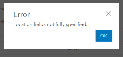
So the data was collected originally in a Office Form. It had locations such as intersection of X an Y or "bus stop". I was originally just going to import the data into the survey and manual move the points. However using the update data to append data it requires you to have an X and Y field in your data, so I went and got all the decimal degree locations for each entry and I was hoping that the conversion would then properly locate them.
X and Y data:

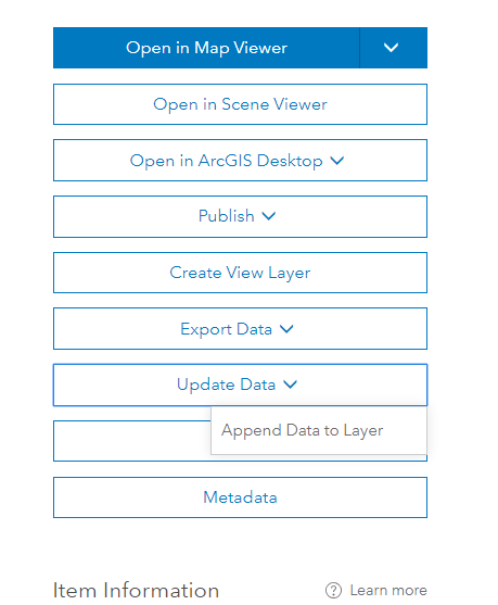
then i go to field matching:
If you don't designate a lat long field from your uploading data it gives:
So thats why i figured that having the decimal degrees in the X and Y would auto recognize them.
- Mark as New
- Bookmark
- Subscribe
- Mute
- Subscribe to RSS Feed
- Permalink
- Report Inappropriate Content
They have to be names Latitude spelled out. Make sure your x/y are in the same projection also! That is why I would do a xy event layer in arcmap then use that file to append.
CSV, TXT, and GPX files—ArcGIS Online Help | ArcGIS
Location fields in CSV and TXT files
To add a CSV or TXT file from a local drive or a CSV file on the web to your map as a feature layer or to publish a local CSV file as a hosted feature layer, the file must include location fields. Location fields can contain coordinate, address, or place information. The first row in the file must contain the location field names. Addresses can be stored in one or more fields. Coordinates must be in two separate fields.
If your file has coordinate fields, Map Viewer uses these fields to locate the features on the map. ArcGIS Online supports the following coordinate reference systems:
- longitude, latitude*
- latitude, longitude*
- Military Grid Reference System (MGRS)
- United States National Grid (USNG)
- Mark as New
- Bookmark
- Subscribe
- Mute
- Subscribe to RSS Feed
- Permalink
- Report Inappropriate Content
Thanks got it working!
- Mark as New
- Bookmark
- Subscribe
- Mute
- Subscribe to RSS Feed
- Permalink
- Report Inappropriate Content
Hi Jason,
I'm having a similar problem. I've published a survey based on an XLS file and now want to get the original data into the feature service on AGO. I have related tables as well in the feature service. I've tried appending and matching the fields but it doesn't seem to keep the related records related. How did you solve your problem? Thanks! -Ray