- Home
- :
- All Communities
- :
- Products
- :
- ArcGIS Survey123
- :
- ArcGIS Survey123 Questions
- :
- Force respondent to manually interact with geopoin...
- Subscribe to RSS Feed
- Mark Topic as New
- Mark Topic as Read
- Float this Topic for Current User
- Bookmark
- Subscribe
- Mute
- Printer Friendly Page
Force respondent to manually interact with geopoint question and/or geosearch
- Mark as New
- Bookmark
- Subscribe
- Mute
- Subscribe to RSS Feed
- Permalink
- Report Inappropriate Content
I’m in the process of migrating an application form for a local design review committee to Survey123. This application requires parcel-level accuracy (due to zoning implications) and the responses will be collected from office-based desktop users rather than field workers on site.
Survey123 has accommodated our needs for this project very elegantly except for in one area: users are able to bypass the required geopoint question because the default location I have set apparently satisfies it. To that end, I have two questions:
- Is there a way to force respondents to manually interact with the geopoint question -- e.g., drag the marker from its default position, zoom to a certain level, or select a location using geosearch?
- Whenever I open one of these user-generated records to QA it, the geopoint reverts to 0,0 lat-long. This happens regardless of whether I edit the record through the survey’s Data tab or by adding “?mode=edit&objectId=###” to the end of the URL. How can I retain the original user response once the record is opened for editing?
Many thanks,
Will
- Mark as New
- Bookmark
- Subscribe
- Mute
- Subscribe to RSS Feed
- Permalink
- Report Inappropriate Content
Hi Will,
One way to enforce manual interaction would be to check for the default value via a constraint and make it invalid if it is there.
- Mark as New
- Bookmark
- Subscribe
- Mute
- Subscribe to RSS Feed
- Permalink
- Report Inappropriate Content
Hi James,
Thanks for that suggestion -- I added these tweaks to the XLS form and it seems to do the trick:

Upon opening the web form, the geopoint question requires attention in order to satisfy the sum constraint:

Worth noting: originally, I had encoded Relevant expressions for the X and Y fields in the table section above that revealed them only once a record's status was upgraded from "Submitted" to "Under Review". I had to remove those expressions in order to get the constrain to work; e.g., any fields that derived properties from the geopoint had to be active (but "hidden") in order for the constraint to work from the jump.
Unfortunately, the lat-long continues to reset to 0,0 once I open a record up for editing in the webform (see my reply to Jody below).
Thanks for your help,
Will
- Mark as New
- Bookmark
- Subscribe
- Mute
- Subscribe to RSS Feed
- Permalink
- Report Inappropriate Content
Hi Will,
Thanks for the feedback. Regarding the second point of retain the original user response once the record is opened for editing, could you please confirm that you are using a survey created by Survey123 Connect which is the desktop tool instead of a survey created on browser?
Thanks,
Jody Zheng Liu
- Mark as New
- Bookmark
- Subscribe
- Mute
- Subscribe to RSS Feed
- Permalink
- Report Inappropriate Content
Hi Jody,
Thanks for addressing this second point. Yes, the survey was created in Survey123 Connect. I've attached the current XLS form to my original post in case that's helpful.
Interestingly, the geopoint displays correctly in the expandable "Editing" sidebar within the Data tab, but once I open the web form for that particular entry using URL parameters, the geopoint resets to 0,0, like so:

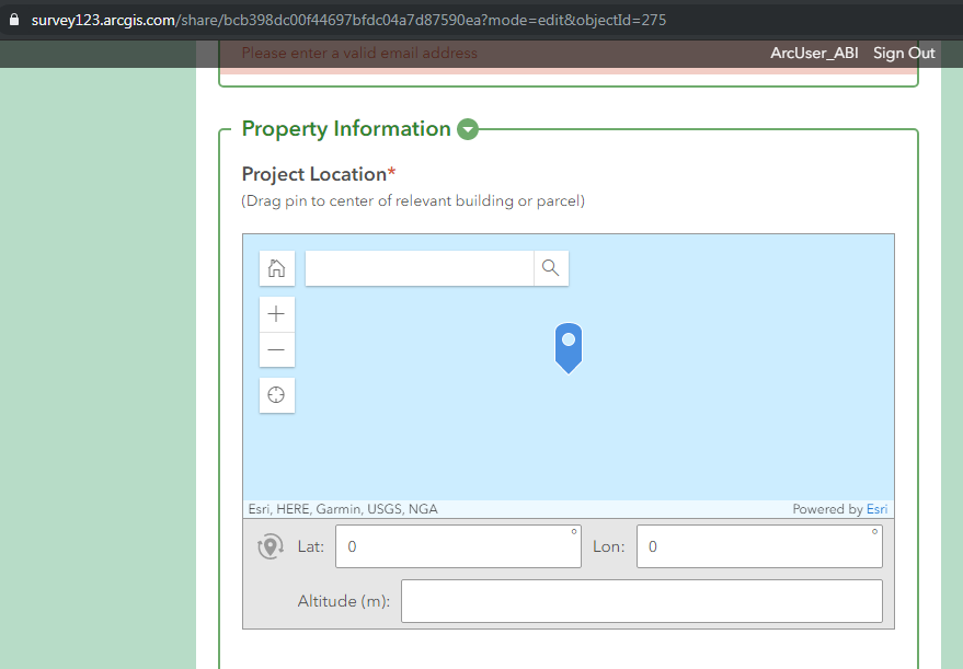
I should mention that the Calculation column in rows 100 and 101 call on coordinates from the geopoint question, e.g., pulldata("@geopoint", ${DRC_Cases_092719}, "x". I wondered if this was causing the issue, but removing those expressions didn't stop the geopoint from resetting to 0,0 when editing in the webform.
Thanks,
Will
- Mark as New
- Bookmark
- Subscribe
- Mute
- Subscribe to RSS Feed
- Permalink
- Report Inappropriate Content
Does this work yet for the web form? I'm having users not interact with the geopoint causing the points to land on top of each other.