- Home
- :
- All Communities
- :
- Products
- :
- ArcGIS Survey123
- :
- ArcGIS Survey123 Blog
- :
- World Milk Day Release (2.1)
World Milk Day Release (2.1)
- Subscribe to RSS Feed
- Mark as New
- Mark as Read
- Bookmark
- Subscribe
- Printer Friendly Page
- Report Inappropriate Content
Working on this release involved quite a bit of stracciatella and chocolate ice cream, but we knew the update would be dedicated to the World Milk Day, so we never felt too guilty. World Milk Day is celebrated on June 1st since 2011 and it is an opportunity to learn about milk and its qualities. If you don’t have a chance to break the daily routine visiting a nearby dairy farm, celebrate World Milk Day eating a delicious ice cream and reading about this tasty release.
The Survey123 field app build number is now 2.1.6. As usual, you can download the app from the iTunes, Google Play and Amazon stores.
Survey123 Connect for ArcGIS is now at version 2.1.9 and is also ready for Windows, Mac and Ubuntu Linux at our Downloads page.
To ensure the Survey123 website works as expected, play safe and clear your browser cache.
Here is what is new:
Survey123 website
In our last update, the Survey123 website included major improvements such as support for changing the design of already published surveys and the new rating question. This release includes a handful of useful features:
Sharing survey results reports with others: You can easily share the results of a survey with others via a simple link. The survey results report includes an overview page with information about the number of records submitted, participants etc. The Data and Analyze tabs in the report include detailed information about every record submitted as well as aggregated information.
To share your results, go into the Collaborate tab, switch to the Analyze section and share your survey results with groups within your organization. Once you have shared the results of a survey through the Collaborate tab, you can grab the URL of your survey results report and include it in an e-mail, web page etc.

The survey results report link is a very convenient way for you to share with others a live picture of all data captured via Survey123.
If you want anonymous users to look at the results of your survey, you can simply make your results public by sharing your survey with everyone. If you make your results public, we currently only let users look at the aggregated results in the Analyze tab; the Overview and Data tabs will only be visible to logged-in users. We are open to change this and allow anonymous access to the overview and data pages, but wanted to hear your feedback first.
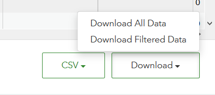
Download data with a date filter: From the Data tab you can download your survey data in shapefile, file geodatabase and CSV formats. You can now use time filters to more selectively define the amount of data you want to download. For example, you can now limit the downloaded features to those captured in the past week, month, or within two specific dates you define.
Print Photo Size: New options have been added in the Print Report function so you can control the size that the photos will have once printed on paper. By default, photos in your reports will be added at a small size, but you can decide to make them bigger. This is useful when you want detailed photos in your reports.
Website optimization: A lot of work went into making the website faster, reducing the size of files downloaded into your browser and optimizing how they get loaded on it. This may not be relevant to you if you have a fast internet connection, but it will make a significant difference if you don’t.
Connecting the Survey123 website to Portal for ArcGIS: Starting with this release, you can have the Survey123 website work against your own ArcGIS Enterprise deployment. This means that you can now easily create surveys from your web browser, manage your surveys and leverage all the Survey123 reporting tools against your own instance of ArcGIS Enterprise, even when working behind a firewall. By connecting our Survey123 website with your own instance of Portal for ArcGIS, you get the latest features we implement in survey123.arcgis.com, but all data and surveys are strictly kept in your own infrastructure.
The mechanics for connecting the Survey123 website to your own ArcGIS Enterprise are described in this KB article.
The minimum version of Portal for ArcGIS you require for the above to work is 10.4 . You also must have an ArcGIS Data Store configured with your Portal for ArcGIS Hosted Server.
Web Designer’s ability to edit already published surveys requires Portal for ArcGIS 10.5.1, which is scheduled to be released in July 2017.
Note that what is described above follows a hybrid architecture, where some components such as our Survey123 website and REST API are hosted in Esri's cloud, while other components such as your data, feature services, form items and portal are hosted in your own infrastructure. As you will see later in this post, we are working towards enabling you to deploy the entire Survey123 web site on-premises.
Survey123 Connect and Survey123 field app
Support for ArcGIS Server Federated Services: This is the first release with support for federated services. This is important for many of you who already have ArcGIS Server, and want to have Survey123 work against it.
If you want to build a survey on top of an existing Feature Service, simply go into Survey123 Connect and login to a portal, click on New Survey and select the Feature Service choice. A gallery with all feature services you have access to will be shown. This list of feature services was limited to Hosted Feature Services in previous versions, but in this release the list will also include feature services from Federated Servers with your portal.
Survey123 Connect will automatically create an XLSForm for the selected feature service, so you can modify it to your taste. When the survey is published, a new Form item will be created in your ArcGIS organization and will be connected to the feature service you selected, so all data captured will go into it.
You can find more information about working with existing feature services in our help.
Note : It is possible to work against non-federated feature services following the step by step instructions outlined in this KB article
Enhanced Inbox: We introduced the Inbox concept in version 2.0. This two-minute video tutorial describes what the Inbox is all about. With 2.1, you can now refine your Inbox queries so they include variables such as the username. This is a handy feature allowing you to better control what surveys will be retrieved in the end-users Inbox. For example, say you want to populate the Inbox with surveys assigned to the logged in user. A query like this will do the trick:

The variable ${username} refers to the unique username as shown in the ArcGIS profile of the logged-in user. You can also use other information from the profile such as ${email}, ${firstName} and ${lastName}.
Repeat Aggregated Functions: A set of new functions are available so you can count, sum and get the maximum and minimum value within responses across a repeat. These functions are handy in many situations. For example, say you want to create a smart form to perform asset inspections and you want to detail defects and the estimated cost or repairs. You can calculate the total cost of repairs by using the sum() function. You can also use the max() function to highlight the repair item that is the most expensive.
Typically, the sum, count, max and min functions are used within the calculation column, but technically you can also use them to build constraint and relevant expressions. For example, you can make a multiline text justification question relevant if the total cost of repairs exceeds a particular amount.
If you want to see these aggregation functions in action, you can give our Daily Fishing Log survey a try. You can either try the survey in your web browser or if you happen have the Survey123 field app installed, from the Survey123 app.
If you are curious how these functions were used in the Daily Fish Survey log example, here is a screenshot of the XLSForm.
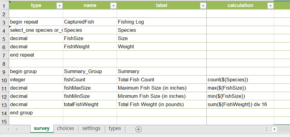
An XLSForm sample was also added to Survey123 Connect (Create New Survey-Samples) to illustrate the different repeat aggregation functions. Even the Daily Fishing Log survey is now part of our Community Samples.
Silent Installation: You can now install Survey123 Connect and the Survey123 field app silently through a series of scripts. This is useful when you plan to deploy or update Survey123 Connect or the Survey123 field app at large scale within your organization. Marika recently wrote a great blog post on this topic where you can learn more about this.
Survey Templates and Samples: Several new community templates have been added in this release. Our templates can provide you a quick starting point for your projects, or at the very least a bit of inspiration. You can access these templates in Survey123 Connect for ArcGIS.
Select New Survey and then browse templates in the Community category.
New templates in this release:
- Pothole Report Hazard
- Combined Sewer Overflow Notification
- Daily Fishing Log
- Manhole Inspection
- Residential Septic Tank Inspection
- Wildlife Roadkill Report
Other fixes and enhancements: As in every release, we also added other minor enhancements and fixes, which are detailed in the What's new help topic.
Next steps
Our next scheduled release is set for late June and will include bug-fixes only.
The next release with functional enhancements will be 2.3 in late July or early August. Some of the features we are working on include:
- Next Generation Web Forms: Our goal in 2.3 is to be able to render in a web browser any survey regardless of its sophistication. At the moment, you can only render surveys in a web browser if you authored them with Web Designer. 2.2 will extend support to surveys authored in Survey123 Connect.
- On-premises deployments of the Survey123 website: In this release we presented a hybrid approach that lets you take advantage of the Survey123 website even if working against your own ArcGIS Enterprise deployment. At 2.3, we want to deliver a solution for those of you who want to deploy Survey123 entirely in your own infrastructure,even if working completely disconnected from the internet.
Expanding support for editing with repeats is planned for 2.4, which will most likely come in September.
If you are eager to try the above features and others planned for the 2.3 release, you can access them as Beta through our Early Adopter website.
We will continue looking closely at your comments in this GeoNet Group and our Early Adopter Community Website.
Keep your feedback coming!
You must be a registered user to add a comment. If you've already registered, sign in. Otherwise, register and sign in.