- Home
- :
- All Communities
- :
- Products
- :
- ArcGIS Spatial Analyst
- :
- ArcGIS Spatial Analyst Questions
- :
- What are the output fields of the Contour tool in ...
- Subscribe to RSS Feed
- Mark Topic as New
- Mark Topic as Read
- Float this Topic for Current User
- Bookmark
- Subscribe
- Mute
- Printer Friendly Page
What are the output fields of the Contour tool in Spatial Analyst?
- Mark as New
- Bookmark
- Subscribe
- Mute
- Subscribe to RSS Feed
- Permalink
- Report Inappropriate Content
I've read through the tool help, and done search after search in google, and nowhere can I find a description of the output feature class produced by the contour tool. Specifically, I'd like to know the fields that would be populated in any output contour shapefile for use in other steps in a python script. I was hoping to find this documented somewhere so I didn't have to do a 'test' contour to see what the output format will be, as the rasters I'm working with are fairly big, so that's a lot of processing time to find out something that should be explained in the documentation. Am I missing something obvious, or is this just omitted from the Contour tool help and item description?
- Mark as New
- Bookmark
- Subscribe
- Mute
- Subscribe to RSS Feed
- Permalink
- Report Inappropriate Content
take a subset of your raster by setting the extent to a smaller area using the raster extent properties in the Environments tab of the Contour tool... Output Extent (Environment setting)—Help | ArcGIS for Desktop
You don't need to contour the whole raster to get some idea
Contour—Help | ArcGIS for Desktop
If memory serves, the only additional field is the contour value, so select the base contour and the intervals to match what you want
- Mark as New
- Bookmark
- Subscribe
- Mute
- Subscribe to RSS Feed
- Permalink
- Report Inappropriate Content
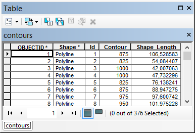
The resulting contours featureclass is kinda straightforward:
Shapefile:
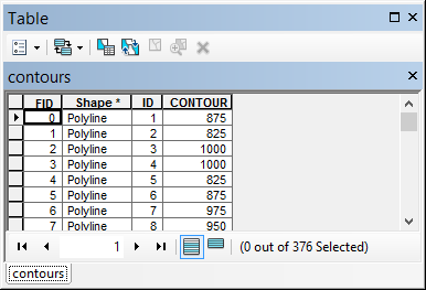
Featureclass in file geodatabase: