- Home
- :
- All Communities
- :
- Products
- :
- ArcGIS Spatial Analyst
- :
- ArcGIS Spatial Analyst Questions
- :
- Re: Slope percent rise issue
- Subscribe to RSS Feed
- Mark Topic as New
- Mark Topic as Read
- Float this Topic for Current User
- Bookmark
- Subscribe
- Mute
- Printer Friendly Page
Slope percent rise issue
- Mark as New
- Bookmark
- Subscribe
- Mute
- Subscribe to RSS Feed
- Permalink
- Report Inappropriate Content
Hi, I am in desperate need of help. I am trying to generate a slope raster from a 30m DEM in percentage rise, but the resulting values are exactly the same when I run the Slope tool in degrees and in percent rise. Can someone please assist me?
- Mark as New
- Bookmark
- Subscribe
- Mute
- Subscribe to RSS Feed
- Permalink
- Report Inappropriate Content
Is the raster in a Projected coordinate system?
How are you comparing the rasters? (Not visually I hope)
Can you show the raster statistics for both?
... sort of retired...
- Mark as New
- Bookmark
- Subscribe
- Mute
- Subscribe to RSS Feed
- Permalink
- Report Inappropriate Content
Hi, Thanks for the quick response!
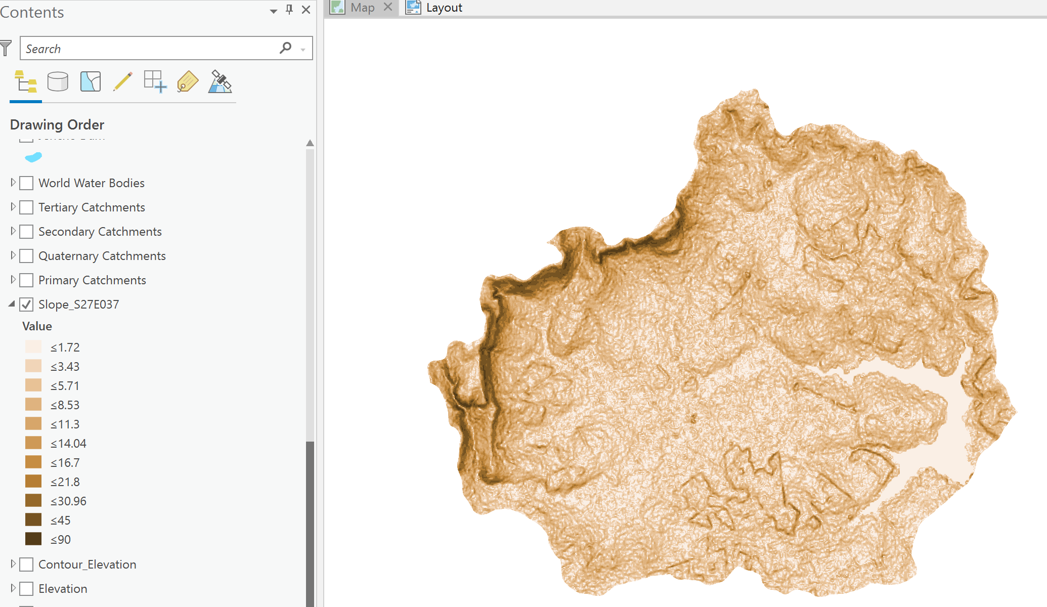
No, not comparing them visually, the values under the layer at symbology are exactly the same, and for percentage rise the highest value is <90, which cannot be percent as the area definitely has a slope higher than 90%.
I have attached some images, hope they are the ones you were looking for
- Mark as New
- Bookmark
- Subscribe
- Mute
- Subscribe to RSS Feed
- Permalink
- Report Inappropriate Content
as Dan say's pretty sure this is a projection issue, Project the raster to planimetric or use the geodesic method on the slope tool.
- Mark as New
- Bookmark
- Subscribe
- Mute
- Subscribe to RSS Feed
- Permalink
- Report Inappropriate Content
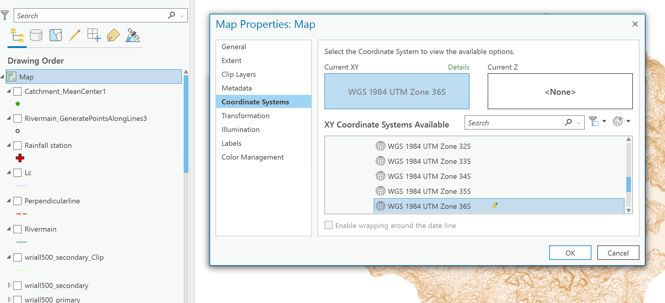
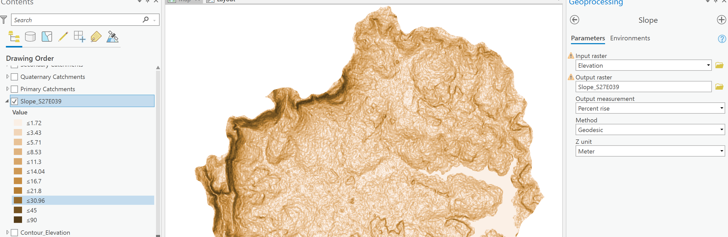
Hi David, thanks for the advice. I am new to the game, but I think I did project the raster to a planimetric coordinate system, and I definitely tried geodesic as well as planar on the slope tool. I just tried again, no success. I will type my exact steps, can you please take a look and see if you can find my error?
- Open new project
- Import my 30 m DEM
- right click on MAP in the contents pane and change the coordinate system to WGS 1984 UTM Zone 36S (this is where I am working) see attached image
- Select slope tool (see image)
- input raster is the DEM
- Output measurement is percentage rise
- Method (tried both planar and geodesic)
- The result is still in degrees (see image)
I really hope you can find my mistake
- Mark as New
- Bookmark
- Subscribe
- Mute
- Subscribe to RSS Feed
- Permalink
- Report Inappropriate Content
The projection you have defined is for the Map/Data Frame. To my knowledge this is honoured in some but very few geoprocessing tools. What is the output if you use GEODESIC method? or if you use the Project Tool to actually project the elevation into that UTM zone, then run the slope on that new raster.
- Mark as New
- Bookmark
- Subscribe
- Mute
- Subscribe to RSS Feed
- Permalink
- Report Inappropriate Content
- Mark as New
- Bookmark
- Subscribe
- Mute
- Subscribe to RSS Feed
- Permalink
- Report Inappropriate Content
- Mark as New
- Bookmark
- Subscribe
- Mute
- Subscribe to RSS Feed
- Permalink
- Report Inappropriate Content
Hi CarlTaljaard,
Could you please share with us the ArcGIS Pro version that you are using? If by any chance, you are using 2.7, could you please update your ArcGIS Pro 2.8 and try using the Slope tool again?
If updating ArcGIS Pro does not solve your issue, could you please post here the raster statistics for both the Percent Rise output and the Degree output? I think you only shared the raster statistics for one output above. I will reach out to you for more information in case the statistics look erroneous!
Please also let us know if updating the Pro version worked!
Thank you,