- Home
- :
- All Communities
- :
- Products
- :
- ArcGIS Spatial Analyst
- :
- ArcGIS Spatial Analyst Questions
- :
- Re: Reclassify: NoData Bug
- Subscribe to RSS Feed
- Mark Topic as New
- Mark Topic as Read
- Float this Topic for Current User
- Bookmark
- Subscribe
- Mute
- Printer Friendly Page
Reclassify: NoData Bug
- Mark as New
- Bookmark
- Subscribe
- Mute
- Subscribe to RSS Feed
- Permalink
- Report Inappropriate Content
If I set my environment settings correctly (every other tool in spatial analyst masks things properly), and then reclassify a raster, and change the NoData value from NoData to (for example) -99, when it produces the output raster, it doesn't mask it. It can't seem to differentiate between NoData areas that fall within the study area mask, and NoData areas that fall outside of the study area mask. See attached screencap for example. I then have to run Extract to Mask to get it to clip my reclassified raster properly.
I need the NoData areas to be an integer for some other processing I am doing, I can't leave them as NoData. Obviously I can keep doing what I'm doing and just run the Extract to Mask all the time, but it's just a pain when I have to batch process lots of maps, because now it's taking double the amount of time having to do the extra step.
Are ESRI aware of this bug? And can they please fix it?
Issue has been replicated on 10.3.1, 10.4, and 10.5.
- Mark as New
- Bookmark
- Subscribe
- Mute
- Subscribe to RSS Feed
- Permalink
- Report Inappropriate Content
not sure I follow, you have an area which has to remain rectangular, You have a mask, which I presume is everything not classed as -99. within that irregular area, you have some class 0's. Were those 0's formerly -99 (no data) before the reclass of -99 to 0? I am just trying to follow the transition steps in your process since you seem to show the 'after' and not the 'before' shot, unless I am mistaken
- Mark as New
- Bookmark
- Subscribe
- Mute
- Subscribe to RSS Feed
- Permalink
- Report Inappropriate Content
If you would like Esri to fix this problem, if you can, it's best to contact Esri support and file an incident.
In general I recommend avoiding using polygons as masks - it is more efficient and robust to convert your polygon mask to raster, map it to a 1/NoData raster, with raster calculator: SetNull(IsNull("p2ras"), 1). Then use the raster as a mask.
- Mark as New
- Bookmark
- Subscribe
- Mute
- Subscribe to RSS Feed
- Permalink
- Report Inappropriate Content
Apologies for confusion. The mask IS a raster. It works for every other function, just not reclassify. See additional screencaps below:
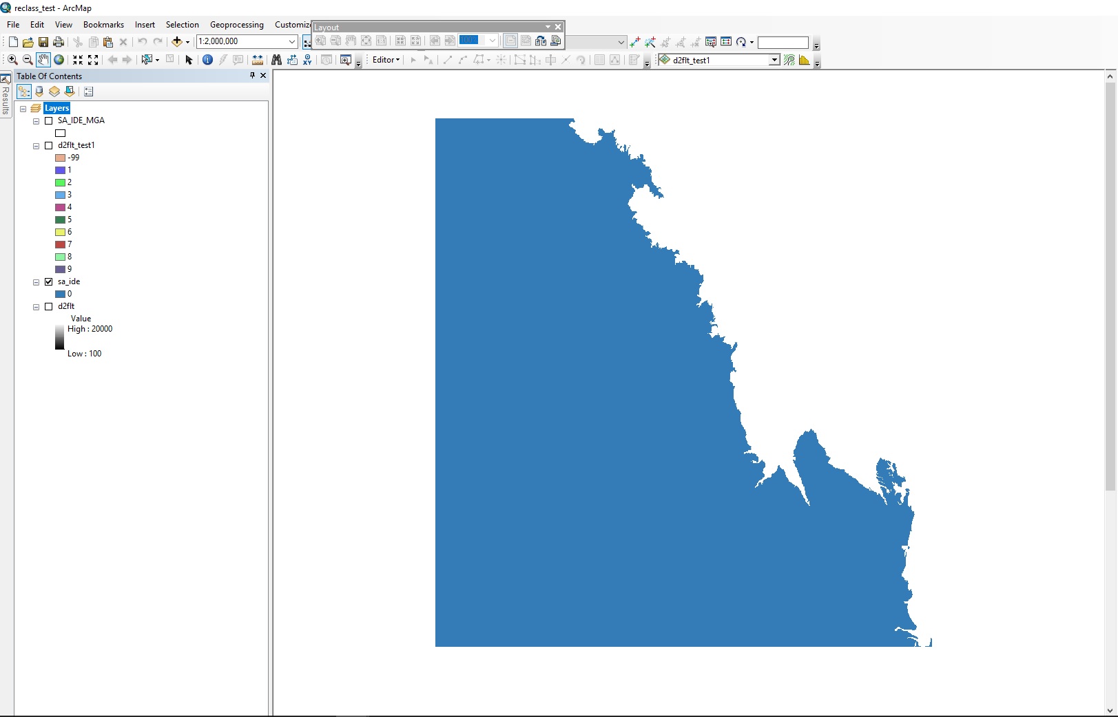
Mask is a raster:
Original distance grid that needs to be reclassified (it shows the polygon version of the study area just so you can see the extents it is meant to clip to):
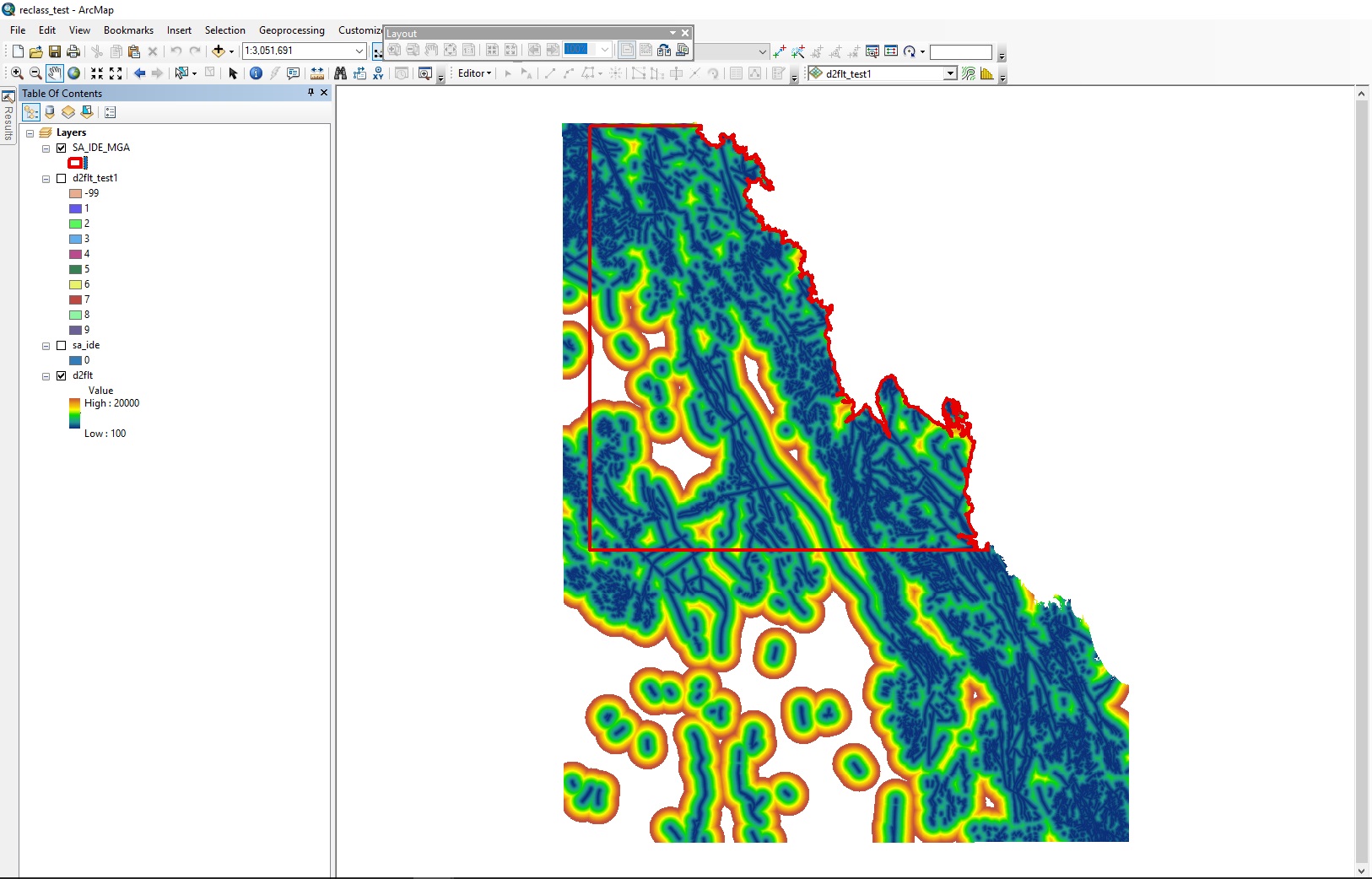
You can see there are NoData areas within the study area, and the NoData areas to the north-east which are outside of the study area mask. When you use Reclassify, and you set the NoData value to an integer instead of leaving it as NoData, it gives the following:

Which as you can see, correctly attributes the NoData area as -99 within the study area mask, but incorrectly attributes the NoData area that falls outside the study area mask as -99 rather than clipping it out.
I hope this explains the error better?
- Mark as New
- Bookmark
- Subscribe
- Mute
- Subscribe to RSS Feed
- Permalink
- Report Inappropriate Content
if the brownish area is nodata, then I am still confused, since a map can only have 1 no data. your 2nd last map shows nodata as devoid of color, when you did it a second time, it becomes -99
If you are referring to much smaller areas, then you will have to zoom in to show how one nodata area becomes a value and the other doesn't. And check to ensure that nodata remains no data during a reclass
- Mark as New
- Bookmark
- Subscribe
- Mute
- Subscribe to RSS Feed
- Permalink
- Report Inappropriate Content
So you're saying that it cannot differentiate between NoData inside the mask and NoData outside the mask? That's a very fundamental problem. They are different things.
Literally every other tool in Spatial Analyst can mask the output properly, except for this one particular case in Reclassify where you modify the NoData value to something else.
- Mark as New
- Bookmark
- Subscribe
- Mute
- Subscribe to RSS Feed
- Permalink
- Report Inappropriate Content
What I would do in a case like that... lets assume that this is a shoreline... I would have reclassed the really big nodata area as water/ocean/whatever, so your mask area would have been water and land, then do what you need with the area within the masked area reclassifying non-water... then your nodata would be retained.
I haven't seen two nodata values in a resultant raster, because I haven't done similar operations in the way you did, so maybe it is an error, but I wouldn't have seen it
- Mark as New
- Bookmark
- Subscribe
- Mute
- Subscribe to RSS Feed
- Permalink
- Report Inappropriate Content
It is in fact the coastline, yes 
The problem is that I have another script to run statistics which requires me to enter a value for the NoData class. I can't keep the ocean as a class because it messes up the statistics, I need it to be explicitly masked out. I can do this by running the Extract to Mask tool after the Reclassify tool, there is a workaround for this problem. It's just that when you've got a lot of very large grids at high resolution, this workaround ends up doubling your processing time, making an already time consuming job even worse.
I want to know why the Reclassify tool can't just clip the resulting output raster back to the mask properly - like it does in literally every other tool in Spatial Analyst.
I've logged the case with ESRI as per the advice in this thread. Will see what they say.
- Mark as New
- Bookmark
- Subscribe
- Mute
- Subscribe to RSS Feed
- Permalink
- Report Inappropriate Content
Arianne... any news on the case report?
- Mark as New
- Bookmark
- Subscribe
- Mute
- Subscribe to RSS Feed
- Permalink
- Report Inappropriate Content
Hi Dan,
So far the response from ESRI was: "that's weird, please send us the data". Which I've done, and am awaiting further response.
Cheers
Arianne