- Home
- :
- All Communities
- :
- Products
- :
- ArcGIS Spatial Analyst
- :
- ArcGIS Spatial Analyst Questions
- :
- Re: Creating Link File for the Warp From File Tool
- Subscribe to RSS Feed
- Mark Topic as New
- Mark Topic as Read
- Float this Topic for Current User
- Bookmark
- Subscribe
- Mute
- Printer Friendly Page
Creating Link File for the Warp From File Tool
- Mark as New
- Bookmark
- Subscribe
- Mute
- Subscribe to RSS Feed
- Permalink
- Report Inappropriate Content
Hello,
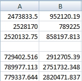
I'm trying to use the "Warp From File" tool under Data Management Tools>Projections and Transformations>Raster. It asks for a link file for the control points. I created a tab delimited text file using excel; plotting X coordinates in Column A and Y Coordinates in Column B with a row missing to separate the Source Coordinates and the Target Coordinates (Image).
This didn't work.
Is there any reference on how the link file should be created? All I know is that the format is a .txt file. Is it best to use comma, space, tab delimited text? Do I need to add Source and Target header information? There is nothing on this subject. I know it looks like the X and Y coordinates are reversed in the source coordinates, but this is correct.
Thank you to anyone who replies!
Solved! Go to Solution.
Accepted Solutions
- Mark as New
- Bookmark
- Subscribe
- Mute
- Subscribe to RSS Feed
- Permalink
- Report Inappropriate Content
You need to add control points by using the Georeferencing toolbar. Once the control points are added (with their correct XY/Lat.Lon), > View Link Table > Save it s a text file.

Think Location
- Mark as New
- Bookmark
- Subscribe
- Mute
- Subscribe to RSS Feed
- Permalink
- Report Inappropriate Content
You need to add control points by using the Georeferencing toolbar. Once the control points are added (with their correct XY/Lat.Lon), > View Link Table > Save it s a text file.
Think Location
- Mark as New
- Bookmark
- Subscribe
- Mute
- Subscribe to RSS Feed
- Permalink
- Report Inappropriate Content
Thank you Jayanta! Much appreciated.