- Home
- :
- All Communities
- :
- Products
- :
- ArcGIS Spatial Analyst
- :
- ArcGIS Spatial Analyst Questions
- :
- Re: Aggregate (Spatial Analyst) outputs the same v...
- Subscribe to RSS Feed
- Mark Topic as New
- Mark Topic as Read
- Float this Topic for Current User
- Bookmark
- Subscribe
- Mute
- Printer Friendly Page
Aggregate (Spatial Analyst) outputs the same values whatever statistic is requested
- Mark as New
- Bookmark
- Subscribe
- Mute
- Subscribe to RSS Feed
- Permalink
- Report Inappropriate Content
I am experiencing a problem using the Aggregate (Spatial Analyst) tool in both ArcGIS Desktop 10.6.1 and ArcPro 2.2.1 to calculate statistics for generalised raster cells.
I have a 1km resolution DEM from which I want to calculate the MAXIMUM cell value within the cells of a 5km raster. The origins of both rasters are the same.
My simple test data set (in Aggregate.gdb) is a 5x5 1km2 elevation grid (ScotDEMCellAOI) with values as follows:
OBJECTID | Value | Count | |
1 | 456 | 1 | 456 |
2 | 459 | 1 | 459 |
3 | 460 | 1 | 460 |
4 | 466 | 1 | 466 |
5 | 488 | 1 | 488 |
6 | 489 | 1 | 489 |
7 | 496 | 1 | 496 |
8 | 499 | 1 | 499 |
9 | 500 | 1 | 500 |
10 | 501 | 1 | 501 |
11 | 507 | 1 | 507 |
12 | 511 | 1 | 511 |
13 | 513 | 2 | 1026 |
14 | 521 | 1 | 521 |
15 | 522 | 1 | 522 |
16 | 538 | 1 | 538 |
17 | 541 | 1 | 541 |
18 | 544 | 1 | 544 |
19 | 546 | 1 | 546 |
20 | 576 | 1 | 576 |
21 | 580 | 1 | 580 |
22 | 598 | 1 | 598 |
23 | 599 | 1 | 599 |
24 | 600 | 1 | 600 |
Max | 600 | ||
Mean | 520.92 |

ScotDEMCellAOI
I wish to aggregate these cells to the coincident 5*5 km cell (CellAOI5km).
I populate the Aggregate (Spatial Analyst) as follows:
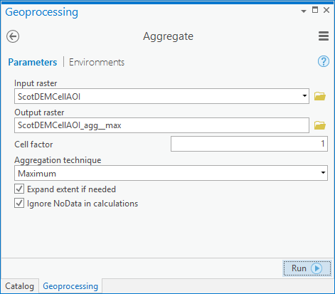
The output is a single 5*5 cell with the value 496?
I get the same output when I try and calculate other statistics?
Am I doing something wrong?
Solved! Go to Solution.
Accepted Solutions
- Mark as New
- Bookmark
- Subscribe
- Mute
- Subscribe to RSS Feed
- Permalink
- Report Inappropriate Content
Hi David.
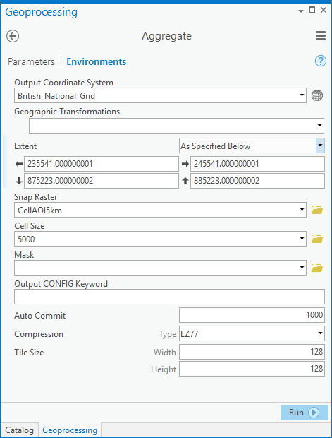
It looks like you set the Cell Factor to 1 and the Environment Cell Size to 5000 (m).
I think if you try setting the Cell Factor to 5, and leaving the Environment Cell Size to the default (or 1000m), you should get the results you're expecting.
The intention of the tool is to produce a coarser (reduced resolution) version of the input raster, with the multiplier specified by the Cell Factor. In the scenario described above, the input is essentially being resampled to the 5000 m resolution first, before any statistical option is applied.
Hopefully this resolves your issue.
Cheers,
Juan Laguna
Spatial Analyst Team, Esri
- Mark as New
- Bookmark
- Subscribe
- Mute
- Subscribe to RSS Feed
- Permalink
- Report Inappropriate Content
Hi David.
It looks like you set the Cell Factor to 1 and the Environment Cell Size to 5000 (m).
I think if you try setting the Cell Factor to 5, and leaving the Environment Cell Size to the default (or 1000m), you should get the results you're expecting.
The intention of the tool is to produce a coarser (reduced resolution) version of the input raster, with the multiplier specified by the Cell Factor. In the scenario described above, the input is essentially being resampled to the 5000 m resolution first, before any statistical option is applied.
Hopefully this resolves your issue.
Cheers,
Juan Laguna
Spatial Analyst Team, Esri