- Home
- :
- All Communities
- :
- Developers
- :
- Native Maps SDKs
- :
- Native SDKs Ideas
- :
- Support for alternate scale-based symbols in ArcGI...
- Subscribe to RSS Feed
- Mark as New
- Mark as Read
- Bookmark
- Follow this Idea
- Printer Friendly Page
- Report Inappropriate Content
Support for alternate scale-based symbols in ArcGIS Runtime
- Mark as New
- Bookmark
- Subscribe
- Mute
- Subscribe to RSS Feed
- Permalink
- Report Inappropriate Content
In ArcGIS Pro, it is possible to add alternate symbols for a set of unique value-derived symbols to allow for different symbology for a given class at different scale ranges. I've attached a screenshot of what I mean.
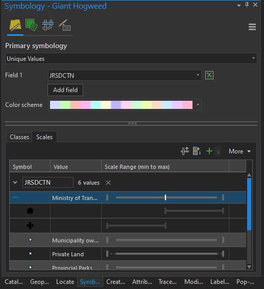
This works great in ArcGIS Pro...I zoom in and out, and the symbol changes completely when going through the scale threshold.
However, when I export the map into a Mobile Map Package and open it in an ArcGIS Runtime app, the scale-changing behavior does not take effect. Instead, the point only shows when in the scale range for the first symbol in the list (i.e. the scale range starting at 0.0), and once I've zoomed through the threshold, the point disappears.
The idea is...enhance the ArcGIS Runtime to support alternate scale-based symbols in the same manner as ArcGIS Pro.
- Mark as Read
- Mark as New
- Bookmark
- Permalink
- Report Inappropriate Content
This is available in Runtime 100.12
See https://developers.arcgis.com/net/reference/release-notes/100.12/#support-scale-based-symbol-classes...
You must be a registered user to add a comment. If you've already registered, sign in. Otherwise, register and sign in.