- Home
- :
- All Communities
- :
- Developers
- :
- Native Maps SDKs
- :
- Qt Maps SDK Questions
- :
- problem with Qt+ArcGis Runtime SDK
- Subscribe to RSS Feed
- Mark Topic as New
- Mark Topic as Read
- Float this Topic for Current User
- Bookmark
- Subscribe
- Mute
- Printer Friendly Page
- Mark as New
- Bookmark
- Subscribe
- Mute
- Subscribe to RSS Feed
- Permalink
- Report Inappropriate Content
hello;
i'am a student in Master2 informatique (GIS) and this my first time i tried to use the Qt with the runtime SDk of arcgis ..i followed the steps in your documents and every think was exactely installed like the document said ..microsoft visuel studio express 2012 + Qt-5.1.1-32 + creator 3.3.0 ..
i integrated the help and the template of argis sdk with Qt creator succefuly ..and the add of win debugger(x86) & c++ compiler 11.0 (x86) in the "KITS" was succed ..every think was succed ..
But the problem is when i compil the template (i added the Qt-5.1.1-32/plugin/platform in build-MyFirstMap-Qt_5_1_1_32-Debug) it show the main window without the map and show this erroros :
"Rendering engine : OpenGL
\Device\HarddiskVolume3\build-MyFirstMap-Qt_5_1_1_32-Debug\debug\MyFirstMap.exeQWindowsGLContext::getProcAddress: Unable to resolve 'glProgramParameteri'
QWindowsGLContext::getProcAddress: Unable to resolve 'glProgramParameteriEXT'
QWindowsGLContext::getProcAddress: Unable to resolve 'glProgramParameteri'
QWindowsGLContext::getProcAddress: Unable to resolve 'glProgramParameteriEXT'
QWindowsGLContext::getProcAddress: Unable to resolve 'glProgramParameteri'
QWindowsGLContext::getProcAddress: Unable to resolve 'glProgramParameteriEXT'"
============================================================================================
my system:
-win 8.1 x64 updated
-graphic card intel 3000 HD updated
-i have no problems with my computer
Thenk You
Solved! Go to Solution.
Accepted Solutions
- Mark as New
- Bookmark
- Subscribe
- Mute
- Subscribe to RSS Feed
- Permalink
- Report Inappropriate Content
Moustafa-
Did you download the Qt version that uses OpenGL? You will specifically need the version that says MSVC2012 OpenGL.
-Luke
- Mark as New
- Bookmark
- Subscribe
- Mute
- Subscribe to RSS Feed
- Permalink
- Report Inappropriate Content
Moustafa-
Did you download the Qt version that uses OpenGL? You will specifically need the version that says MSVC2012 OpenGL.
-Luke
- Mark as New
- Bookmark
- Subscribe
- Mute
- Subscribe to RSS Feed
- Permalink
- Report Inappropriate Content
Salam ;
Thenk you for the replay
after using the Qt MSVC2012 OpenGL Version
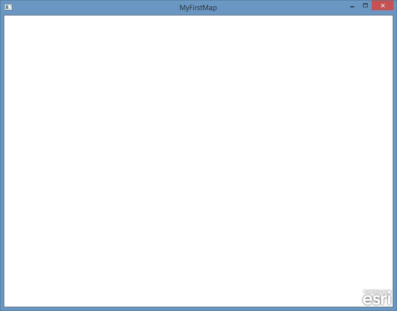
no Errors  But The exe main window stay showed without the map like this :
- Mark as New
- Bookmark
- Subscribe
- Mute
- Subscribe to RSS Feed
- Permalink
- Report Inappropriate Content
Moustafa-
Did you remember to uncomment the layers you want to use in the header and cpp file? For example, in the header, uncomment the include statement -
#include "ArcGISTiledMapServiceLayer.h"
and
EsriRuntimeQt::ArcGISTiledMapServiceLayer* m_tiledServiceLayer;
Then, in the project.cpp, uncomment the line creating the tiled layer and adding it to the map:
m_tiledServiceLayer = new EsriRuntimeQt::ArcGISTiledMapServiceLayer("http://services.arcgisonline.com/ArcGIS/rest/services/World_Topo_Map/MapServer", this);
m_map->addLayer(m_tiledServiceLayer);
With the template, you need to set it up to use the layers you want, and by default, will not show anything (like your above screenshot).
- Mark as New
- Bookmark
- Subscribe
- Mute
- Subscribe to RSS Feed
- Permalink
- Report Inappropriate Content
Ohh Thenk you very much the first problem of OpenGl make me stuped and dont see the code ;

- Mark as New
- Bookmark
- Subscribe
- Mute
- Subscribe to RSS Feed
- Permalink
- Report Inappropriate Content
No worries, glad it is working now