- Home
- :
- All Communities
- :
- Developers
- :
- Native Maps SDKs
- :
- .NET Maps SDK Questions
- :
- Re: Why are dynamic workspace shapefile subdivisio...
- Subscribe to RSS Feed
- Mark Topic as New
- Mark Topic as Read
- Float this Topic for Current User
- Bookmark
- Subscribe
- Mute
- Printer Friendly Page
Why are dynamic workspace shapefile subdivisions gray?
- Mark as New
- Bookmark
- Subscribe
- Mute
- Subscribe to RSS Feed
- Permalink
- Report Inappropriate Content
Hi -
I'm confused by the Dynamic Workspace Shapefile sample with 100.5
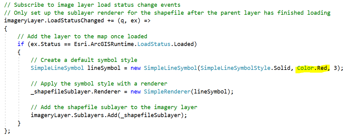
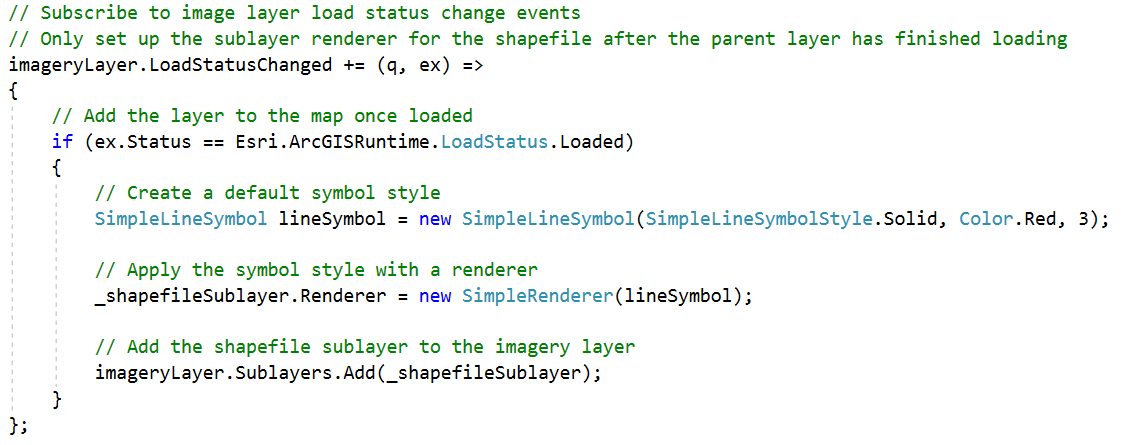
When I pick the subdivisions.shp, the code assigns a simplerenderer based on a red simplelinesymbol.
However, I see gray filled polygons. Is this a bug?
Thanks, Kirk
- Mark as New
- Bookmark
- Subscribe
- Mute
- Subscribe to RSS Feed
- Permalink
- Report Inappropriate Content
It looks like the shapefile you're using is a Polygon shapefile, but you're providing a Line symbol.
Try setting a SimpleFilleSymbol instead. If you just want an outline, use a SimpleFillSymbol and set its Outline to that SimpleLineSymbol you've got, then set the SimpleFillSymbol style to .Null.
- Mark as New
- Bookmark
- Subscribe
- Mute
- Subscribe to RSS Feed
- Permalink
- Report Inappropriate Content
Hi Nicholas -
This code is from the sample, unaltered. I was hoping the sample shows that there's a default renderer being applied behind the scenes (like the way arcobjects does it), and that providing an inappropriate renderer (like a simplerenderer with a linesymbol for a polygon layer) would cause it to revert to the default renderer.
However, if I comment out the line where the _shapefileSublayer.Renderer is being set, nothing in the layer gets displayed. So I guess there's no default, so we're required to set an appropriate renderer, even though this example shows an inappropriate one might still draw something.
Is there a general way (for both shapefiles and enterprise featureclasses) to determine the geometrytype of a TableSublayerSource so that I can create an appropriate renderer?
Thanks,
Kirk
- Mark as New
- Bookmark
- Subscribe
- Mute
- Subscribe to RSS Feed
- Permalink
- Report Inappropriate Content
Hey Kirk.
Granted I'm not familiar with the Local Server samples (I'm an iOS Runtime kind of guy and we don't have Local Server) so I could be mistaken, but it looks like a bug in the sample, tbh. I imagine the sample is opening a shapefile, and you picked one with polygons in it. If you try to render a polygon class with a line symbol, you'll likely not see what you want.
See this sample which is rendering the same Subdivisions shapefile, albeit without Local Server in the mix.
But again, I could be wrong. Do try setting up the _shapefileSublayer.Renderer with a polygon symbol as per the other sample and see if that works. But it looks like either the sample or the SDK is broken.
Nick.
- Mark as New
- Bookmark
- Subscribe
- Mute
- Subscribe to RSS Feed
- Permalink
- Report Inappropriate Content
Hi Kirk,
The sample assumes you're using the sample data that's associated with that sample - it's just showing a discreet workflow.
To make the workflow more generic, you could take a look at the `ArcGISSublayer.MapServiceSublayerInfo` Property and create some conditional logic based on the `ArcGISMapServiceSublayerInfo.GeometryType`.
I will also say the recommended option for accessing Shapefiles is to use ArcGIS Runtime directly rather than go via the Local Server component.
Cheers
Mike
- Mark as New
- Bookmark
- Subscribe
- Mute
- Subscribe to RSS Feed
- Permalink
- Report Inappropriate Content
Hi Michael -
After I get this working, I intend to generalize it to work with EnterpriseWorkspace too. I'm trying to make a workaround for BUG-000120203.
So to get the geometrytype, it looks like I need to call LoadAsync on the sublayer first.
So I changed this code in the sample:
To this:

... and get the Illegal state error.
Am I doing something wrong?
I'm assuming it would get the same error with an SDE workspace too, but will try to confirm.
Also, if I just make a single change to the sample (without changing anything else) I see that LoadStatusChanged never fires. Shouldn't we expect this to fire?

Thanks, Kirk