- Home
- :
- All Communities
- :
- Developers
- :
- Native Maps SDKs
- :
- .NET Maps SDK Questions
- :
- Rotating MapPackage layer also rotates labels
- Subscribe to RSS Feed
- Mark Topic as New
- Mark Topic as Read
- Float this Topic for Current User
- Bookmark
- Subscribe
- Mute
- Printer Friendly Page
Rotating MapPackage layer also rotates labels
- Mark as New
- Bookmark
- Subscribe
- Mute
- Subscribe to RSS Feed
- Permalink
- Report Inappropriate Content
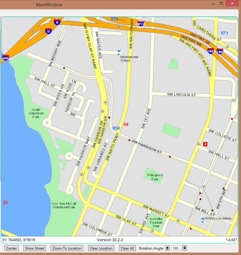
A bug seems to have been introduced between 10.2.3 and 10.2.4 with regards to map rotation and .mpk layers. In 10.2.3 when I rotate the maps, the labels adjusted themselves to always remain readable. In 10.2.4 they now rotate in sync with the map, so at 180 deg, horizontal labels are now upside down. (See attach files).
Andrew Purkis
Versaterm Inc
- Mark as New
- Bookmark
- Subscribe
- Mute
- Subscribe to RSS Feed
- Permalink
- Report Inappropriate Content
On further testing, they will correct themselves if I pan or zoom the map.
Andrew Purkis
Versaterm Inc.
- Mark as New
- Bookmark
- Subscribe
- Mute
- Subscribe to RSS Feed
- Permalink
- Report Inappropriate Content
Follow up:
This was kind of reported under RT.NET-000025 in the beta, and assigned NIM100378.
NIM1000378 has been fixed in 10.3. Is that fix included in 10.2.4?
The labels problem can be seen using the test app I submitted with the original problem report.
If you convert it to 10.2.4, then start it. Don't touch the map; just click the rotate button, and you can see the label problem. As well the enlarged extent is not being rendered, i.e. the corners are cut off.
If you click in the map the labels will be displayed correctly, but the problem originally reported (scale changing) still remains.
Thanks
Andrew Purkis
Versaterm Inc
- Mark as New
- Bookmark
- Subscribe
- Mute
- Subscribe to RSS Feed
- Permalink
- Report Inappropriate Content
Hi,
Are you able to share the Map Package you are testing?
I cannot reproduce this against an online map service (e.g. SampleWorldCities (MapServer) ) but I would like to confirm the behavior against a local map service.
Cheers
Mike
- Mark as New
- Bookmark
- Subscribe
- Mute
- Subscribe to RSS Feed
- Permalink
- Report Inappropriate Content
Hi Mike,
Attached is our test sample.
If you run it. (then for me!)
- Without panning or zooming map, rotate map using Up button, notice 20th and 21st, are not correcting themselves, and the roads are not extending to fill the map.
- Now Pan the map a small amount. Now labels adjust properly and full extent is drawn.
- Continue using Up button, till it gets to ~23 deg. Notice map has jumped scale.
- Press Down button, until you get down to 0, then press up again. You are now back to initial state 1.
I hope that helps
Thanks
Andrew Purkis
Versaterm Inc.
- Mark as New
- Bookmark
- Subscribe
- Mute
- Subscribe to RSS Feed
- Permalink
- Report Inappropriate Content
Unfortunately we were not able to get the fix for the scale issue mentioned in Step #3 into the local server. It was however fixed in ArcGIS Server 10.3 and we hope to have this fix in the local 10.3 server as well.