- Home
- :
- All Communities
- :
- Developers
- :
- Native Maps SDKs
- :
- .NET Maps SDK Questions
- :
- Re: Identify the distance between two co-ordinates...
- Subscribe to RSS Feed
- Mark Topic as New
- Mark Topic as Read
- Float this Topic for Current User
- Bookmark
- Subscribe
- Mute
- Printer Friendly Page
Identify the distance between two co-ordinates (Lat and Long) on a polyline
- Mark as New
- Bookmark
- Subscribe
- Mute
- Subscribe to RSS Feed
- Permalink
- Report Inappropriate Content
Good day team
We are trying to calculate the distance between two co-ordinates on a polyline by passing point 1 and point 2 as a parameter by using the following code:
GeometryEngine.DistanceGeodetic(startPoint, endPoint, LinearUnits.Meters, AngularUnits.Degrees, GeodeticCurveType.Geodesic).DistanceThe result of the above method is only returning the straight line distance instead of considering curves etc. This really pushing our distance calculation off. Could you please advise the best suitable method for the above purpose.
Thanking you in advance.
- Mark as New
- Bookmark
- Subscribe
- Mute
- Subscribe to RSS Feed
- Permalink
- Report Inappropriate Content
> The result of the above method is only returning the straight line distance instead of considering curves etc
I'm not sure what you mean by this? The above code would return the shortest distance between the two points, which will be a straight line (but following the curvature of the earth, rather than going through the earth's crust). However that straight line might not look straight on a projected map and appear curved due to the distortion caused by the projection.
Could you give an example of two coordinates, and the distance you're getting vs. what you'd expect?
- Mark as New
- Bookmark
- Subscribe
- Mute
- Subscribe to RSS Feed
- Permalink
- Report Inappropriate Content
Thank you for the response Morten Nielsen.
Following are my requirements, I'm developing a WPF application using ARCGis SDK for .Net and c# programming.
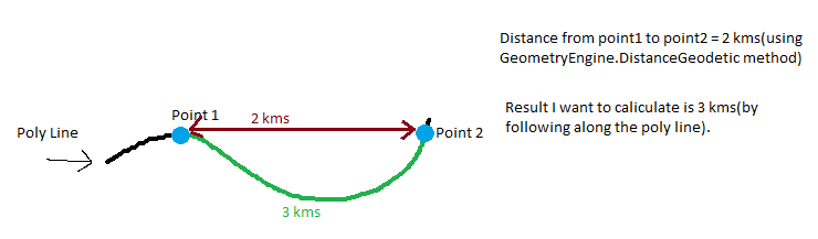
Requirement 1 : need to find the distance between two points by following a poly line.
Here i'm having a Poly line p and point1 and point2 are the points on the polyline p, now want to calculate the distance between Point1 and Point2 by following the polyline which is 3 kms, but GeometryEngine.DistanceGeodetic methods returns the shortest and linear distance between the points which is 2 kms. So please suggest a way to achieve this.
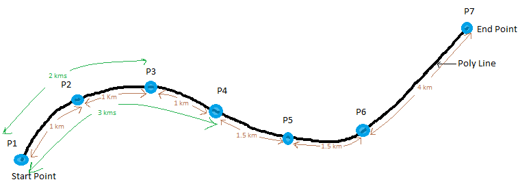
Requirement 2 : need to sort all the points on a polyline by distance(from starting point) in ascending.
Here i'm having a poly line with 7 points as p1,p2,p3,p4,p5,p6,p7. Distance between the points on the polyline as follows
P1 to P2 = 1 kms
P2 to P3 = 1 kms
P3 to P4 = 1 kms
P4 to P5 = 1.5 kms
P5 to P6 = 1.5 kms
P6 to P7 = 4 kms
----------------------------------
Total polyline Distance = 10 kms
So, i want to arrange these points in ascending order based on their distance from start point of the poly line,i.e,.
Point Distance(from start point)
P1 0 kms
P2 1 kms
P3 2 kms
P4 3 kms
P5 4.5 kms
P6 6 kms
P7 10 kms
Thanking you in advance.
- Mark as New
- Bookmark
- Subscribe
- Mute
- Subscribe to RSS Feed
- Permalink
- Report Inappropriate Content
If you want the length of a line, and not the distance between two points, use the GeometryEngine.LengthGeodetic method instead.
Or you can sum up the distances between P1->P2, P2->P3, P3-P4 etc.
- Mark as New
- Bookmark
- Subscribe
- Mute
- Subscribe to RSS Feed
- Permalink
- Report Inappropriate Content
Thank you for the response Morten Nielsen,
As per your suggestion we would like to use the GeometryEngine.LengthGeodetic method to find the length of a polyline between two points. Please note that GeometryEngine.LengthGeodetic expects poly line as a parameter. Could you please explain how do we split the above long poly line into parts at each points as small poly lines or links so that we can calculate the distance for each small poly line or link.
Thanks in advance.