- Home
- :
- All Communities
- :
- Developers
- :
- Native Maps SDKs
- :
- .NET Maps SDK Questions
- :
- Re: HitTestAsync with Polyline
- Subscribe to RSS Feed
- Mark Topic as New
- Mark Topic as Read
- Float this Topic for Current User
- Bookmark
- Subscribe
- Mute
- Printer Friendly Page
HitTestAsync with Polyline
- Mark as New
- Bookmark
- Subscribe
- Mute
- Subscribe to RSS Feed
- Permalink
- Report Inappropriate Content
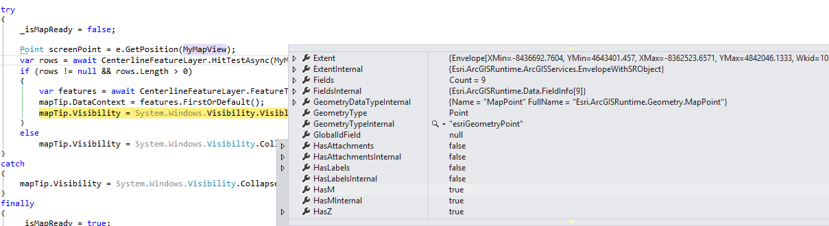
I have a map service and when I call
await MyLayer.HitTestAsync(MyMapView, screenPoint)
with a point feature layer everything works. When I switch to a polyline feature layer I get a popup message box that vshost32.exe has stopped working and I cannot debug from my visual studio window and the app crashes.
Does HitTestAsync support polylines?
- Mark as New
- Bookmark
- Subscribe
- Mute
- Subscribe to RSS Feed
- Permalink
- Report Inappropriate Content
Polylines are supported. Do you have a simple reproducer I can use to test what's going on? Also note that we released 10.2.5 last week which contains many bug fixes.
- Mark as New
- Bookmark
- Subscribe
- Mute
- Subscribe to RSS Feed
- Permalink
- Report Inappropriate Content
I'm using 10.2.5 assemblies. I just downloaded the nuget package this morning.
Here is the code that reproduces the issue against our FeatureLayer. Our layer is M-Aware (HasM = true) and its spatial reference is 4269. I can reproduce with our point layers that also has HasM = true. Using the same code sample I cannot reproduce the issue using this layer hosted by ESRI - Layer: Highways (ID: 1)
Should I contact ESRI support or wait for followup here?
Layer: Centerline History (ID: 6)
Name: Centerline History
Display Field: CENTERLINE_HISTORY_ID
Type: Feature Layer
Geometry Type: esriGeometryPolyline
Description:
Definition Expression:
Copyright Text:
Default Visibility: false
MaxRecordCount: 1000
Supported Query Formats: JSON, AMF
Min Scale: 0
Max Scale: 0
Supports Advanced Queries: true
Supports Statistics: true
Has Labels: false
Can Modify Layer: false
Can Scale Symbols: false
Extent:
- XMin: -180
- YMin: -90
- XMax: 180
- YMax: 90
- Spatial Reference: 4269 (4269)
Drawing Info:
Renderer:Simple Renderer:
Symbol:
Style:
- esriSLSSolid
Color:
- [133, 0, 11, 255]
Width:
- 1
Label:
Description:Transparency:
- 0
Labeling Info:
HasZ: true
HasM: true
Has Attachments: false
HTML Popup Type: esriServerHTMLPopupTypeAsHTMLText
Type ID Field: null
Fields:
- CENTERLINE_HISTORY_ID ( type: esriFieldTypeDouble , alias: CENTERLINE_HISTORY_ID )
- ROUTE_ID ( type: esriFieldTypeDouble , alias: ROUTE_ID )
- SHAPE ( type: esriFieldTypeGeometry , alias: SHAPE )
- SHAPE.LEN ( type: esriFieldTypeDouble , alias: SHAPE.LEN )
- SHAPE.FID ( type: esriFieldTypeOID , alias: SHAPE.FID )
- LINE_ID ( type: esriFieldTypeDouble , alias: LINE_ID )
- DESIGNATOR ( type: esriFieldTypeString , alias: DESIGNATOR , length: 50 )
- LINE_DESCRIPTION ( type: esriFieldTypeString , alias: LINE_DESCRIPTION , length: 254 )
- PRODUCT_TYPE_SCL ( type: esriFieldTypeString , alias: PRODUCT_TYPE_SCL , length: 16 )
- PRODUCT_SUBTYPE_SCL ( type: esriFieldTypeString , alias: PRODUCT_SUBTYPE_SCL , length: 16 )
- PRODUCT_DESCRIPTION ( type: esriFieldTypeString , alias: PRODUCT_DESCRIPTION , length: 254 )
- BEGIN_MEASURE ( type: esriFieldTypeDouble , alias: BEGIN_MEASURE )
- END_MEASURE ( type: esriFieldTypeDouble , alias: END_MEASURE )
- ROUTE_DESCRIPTION ( type: esriFieldTypeString , alias: ROUTE_DESCRIPTION , length: 254 )
- SEQUENCE ( type: esriFieldTypeSmallInteger , alias: SEQUENCE )
- ROUTE_TYPE_CL ( type: esriFieldTypeString , alias: ROUTE_TYPE_CL , length: 16 )
- EFFECTIVE_FROM_DATE ( type: esriFieldTypeDate , alias: EFFECTIVE_FROM_DATE , length: 36 )
- EFFECTIVE_TO_DATE ( type: esriFieldTypeDate , alias: EFFECTIVE_TO_DATE , length: 36 )
- OBJECTID ( type: esriFieldTypeInteger , alias: OBJECTID )
- CHANGE_TYPE_CL ( type: esriFieldTypeString , alias: CHANGE_TYPE_CL , length: 16 )
- LINE_TYPE_CL ( type: esriFieldTypeString , alias: LINE_TYPE_CL , length: 16 )
- LINE_TYPE_DESCRIPTION ( type: esriFieldTypeString , alias: LINE_TYPE_DESCRIPTION , length: 254 )
- ROUTE_TYPE_DESCRIPTION ( type: esriFieldTypeString , alias: ROUTE_TYPE_DESCRIPTION , length: 254 )
- Mark as New
- Bookmark
- Subscribe
- Mute
- Subscribe to RSS Feed
- Permalink
- Report Inappropriate Content
Morten Nielsen I think this might be because our layer is M-Aware. Should I submit this as an official support request to ESRI?
- Mark as New
- Bookmark
- Subscribe
- Mute
- Subscribe to RSS Feed
- Permalink
- Report Inappropriate Content
Hi Darlene,
I tried to reproduce with the following code against ArcGIS Runtime SDK for .NET 10.2.5.857 (nuget package) but I am finding these issues instead (no crash)
M-aware point returns empty result on hittest.
M-aware line do not render.
Could you maybe try the following code with your services?
xmlns:esri="http://schemas.esri.com/arcgis/runtime/2013">
<Grid>
<esri:MapView x:Name="MyMapView">
<esri:Map>
<esri:ArcGISTiledMapServiceLayer ServiceUri="http://services.arcgisonline.com/arcgis/rest/services/World_Topo_Map/MapServer"/>
<esri:FeatureLayer ID="Line">
<esri:ServiceFeatureTable ServiceUri="http://sampleserver6.arcgisonline.com/arcgis/rest/services/USA/MapServer/1" />
</esri:FeatureLayer>
<esri:FeatureLayer ID="Point" >
<esri:ServiceFeatureTable ServiceUri="http://sampleserver6.arcgisonline.com/arcgis/rest/services/USA/MapServer/0"/>
</esri:FeatureLayer>
<esri:FeatureLayer ID="LineHasM">
<esri:ServiceFeatureTable ServiceUri="..." />
</esri:FeatureLayer>
<esri:FeatureLayer ID="PointHasM">
<esri:ServiceFeatureTable ServiceUri="..." />
</esri:FeatureLayer>
</esri:Map>
</esri:MapView>
<Button VerticalAlignment="Top" HorizontalAlignment="Center" Content="Select" Click="Select_Click"/>
</Grid>
private async void Select_Click(object sender, RoutedEventArgs e)
{
string message = null;
try
{
foreach (var layer in MyMapView.Map.Layers.OfType<FeatureLayer>())
{
if (layer.SelectedFeatureIDs.Any())
layer.UnselectFeatures(layer.SelectedFeatureIDs.ToArray());
var geometry = await MyMapView.Editor.RequestPointAsync();
var ids = await layer.HitTestAsync(MyMapView, MyMapView.LocationToScreen(geometry));
if (ids != null && ids.Any())
layer.SelectFeatures(ids);
}
}
catch (TaskCanceledException ex)
{
}
catch (Exception ex)
{
message = ex.Message;
}
if (!string.IsNullOrWhiteSpace(message))
MessageBox.Show(message);
}
Thanks.
- Mark as New
- Bookmark
- Subscribe
- Mute
- Subscribe to RSS Feed
- Permalink
- Report Inappropriate Content
My M-Aware line and point are rendering.
The first time I click select Editor.RequestPointAsync never returns a geometry after waiting for a minute or two. Subsequent calls to Editor.RequestPointAsync results in an exception. This exception is thrown with and without my M-Aware line and point layers. I cannot reach the call to HitTestAsync.
System.Threading.Tasks.TaskCanceledException was caught
HResult=-2146233029
Message=A task was canceled.
Source=mscorlib
StackTrace:
at System.Runtime.CompilerServices.TaskAwaiter.ThrowForNonSuccess(Task task)
at System.Runtime.CompilerServices.TaskAwaiter.HandleNonSuccessAndDebuggerNotification(Task task)
at System.Runtime.CompilerServices.TaskAwaiter`1.GetResult()
at Esri.ArcGISRuntime.Controls.Editor.<RequestPointAsync>d__0.MoveNext()
--- End of stack trace from previous location where exception was thrown ---
at System.Runtime.ExceptionServices.ExceptionDispatchInfo.Throw()
at System.Runtime.CompilerServices.TaskAwaiter.ThrowForNonSuccess(Task task)
at System.Runtime.CompilerServices.TaskAwaiter.HandleNonSuccessAndDebuggerNotification(Task task)
at System.Runtime.CompilerServices.TaskAwaiter`1.GetResult()
at RuntimeMap.MainWindow.<Select_Click>d__14.MoveNext() in c:\TFS\Sandbox\RuntimeMap\RuntimeMap\MainWindow.xaml.cs:line 219
InnerException:
- Mark as New
- Bookmark
- Subscribe
- Mute
- Subscribe to RSS Feed
- Permalink
- Report Inappropriate Content
Did you await RequestPointAsync? It should return a geometry as soon as you tap or click on the map. The TaskCanceledException may have been triggered by the next call to RequestPointAsync, this will cancel previous async call that has not returned. You can also use MapView.MapViewTapped event to get the screen point for hit test.
Could you also share code to reproduce the crash on hit test? Are we using the same version of the API? Are you using WPF, Store or Phone application?
- Mark as New
- Bookmark
- Subscribe
- Mute
- Subscribe to RSS Feed
- Permalink
- Report Inappropriate Content
I used await MyMapView.Editor.RequestPointAsync(). I copied the code you provided. I will test using MapViewTapped and let you know how that works.
I have a WPF application. I attached my code to the post where I include the Centerline Layer properties. I attached it here again as well. I am using 10.2.5.0 assemblies.
- Mark as New
- Bookmark
- Subscribe
- Mute
- Subscribe to RSS Feed
- Permalink
- Report Inappropriate Content
Oh sorry, I didn't realize there was a sample attachment in the thread. It was not visible from the main discussion thread.
I see now why you would get TaskCanceledException if you copied the code I provided from click event handler. Your sample is using MouseMove, which will fire numerous times. Thus starting another RequestPointAsync call which cancels previous async call. I was only using RequestPointAsync to get a screen point but you're free to use e.GetPosition() from MouseEventArgs.
Going back to the original issue. I tried using your sample as is with my own m-aware service. Your sample uses hit test result to query the table for features.
The only thing, I changed was the binding statement since DataContext of the overlay is set to graphics and you want access its Attributes.
<TextBlock Text="{Binding Attributes[OBJECTID]}" />
I did not get a crash though.
- Mark as New
- Bookmark
- Subscribe
- Mute
- Subscribe to RSS Feed
- Permalink
- Report Inappropriate Content
Ok so I suspect it might be something with my map layer then if that code works for you. I initially suspected that it was because my layer is m-aware, but I guess you have eliminated that. Do you have any suggestions for how to identify what could be causing this crash on my layers? The geodatabase is at version 10.1sp0 for Oracle 11g.
I did some testing with additional layers and I found a difference between the layers that work and the layers that don't work. The layers that cause the crash are part of a group layer. Could you test this on your side and see if sub-layers that are part of a group layer crash?
I tried using the following code and it crashed as soon as it iterated over my layer and called HitTestAsync -
private async void MyMapView_OnMapViewTapped(object sender, MapViewInputEventArgs e)
{
string message = null;
try
{
foreach (var layer in MyMapView.Map.Layers.OfType<FeatureLayer>())
{
if (layer.SelectedFeatureIDs.Any())
layer.UnselectFeatures(layer.SelectedFeatureIDs.ToArray());
//var geometry = await MyMapView.Editor.RequestPointAsync();
var ids = await layer.HitTestAsync(MyMapView, MyMapView.LocationToScreen(e.Location));
if (ids != null && ids.Any())
layer.SelectFeatures(ids);
}
}
catch (TaskCanceledException ex)
{
}
catch (Exception ex)
{
message = ex.Message;
}
if (!string.IsNullOrWhiteSpace(message))
MessageBox.Show(message);
}