- Home
- :
- All Communities
- :
- Developers
- :
- Native Maps SDKs
- :
- Java Maps SDK Questions
- :
- How to display a name attribute from a ShapefileFe...
- Subscribe to RSS Feed
- Mark Topic as New
- Mark Topic as Read
- Float this Topic for Current User
- Bookmark
- Subscribe
- Mute
- Printer Friendly Page
How to display a name attribute from a ShapefileFeatureTable on the map?
- Mark as New
- Bookmark
- Subscribe
- Mute
- Subscribe to RSS Feed
- Permalink
- Report Inappropriate Content
Greetings,
I have a CSV file in the following form:
Name,Latitude,Longitude
VS01,2153797.44782777,-10702155.84486526
VS02,2157776.89764107,-10702274.58364621
I have generated the corresponding shape file and used a ShapefileFeatureTable and FeatureLayer, but when the shape is displayed on the map only the points are shown. How can I also visualize the name attribute to the corresponding points?
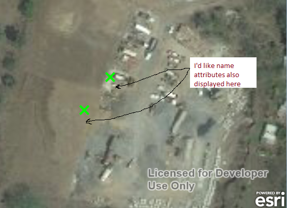
In the attached image is what I've done so far.
I need to do this using the API ArcGis SDK for Java
- Mark as New
- Bookmark
- Subscribe
- Mute
- Subscribe to RSS Feed
- Permalink
- Report Inappropriate Content
Seems like you just need to label the features. You can use the Label tool on the Drawing toolbar to click each feature you want to display the name for, or you can use dynamic labels by enabling them in the feature Layer Properties dialog.
- Mark as New
- Bookmark
- Subscribe
- Mute
- Subscribe to RSS Feed
- Permalink
- Report Inappropriate Content
Sorry! I forgot to mention that I need to do this programmatically. I'm doing this using the ArcGis SDK for Java 10.2.4
- Mark as New
- Bookmark
- Subscribe
- Mute
- Subscribe to RSS Feed
- Permalink
- Report Inappropriate Content
Sorry, can't help with that, but your question is probably better asked in ArcGIS SDK for Java.
- Mark as New
- Bookmark
- Subscribe
- Mute
- Subscribe to RSS Feed
- Permalink
- Report Inappropriate Content
HI,
Well, there are some options:
1) Set labels for Feature Layer - setEnableLabels method
2) Make a use of TextSymbol for Graphic in Grpahic Layers
Add graphics and text—ArcGIS Runtime SDK for Java | ArcGIS for Developers
3) Try to use MapTips
Show MapTips—ArcGIS Runtime SDK for Java | ArcGIS for Developers
Hope this helps,
Adam
- Mark as New
- Bookmark
- Subscribe
- Mute
- Subscribe to RSS Feed
- Permalink
- Report Inappropriate Content
Hello,
Sorry for the delay of my response, I'd been working out.
Option 2 is not an alternative because I have a great number of points, and all of them are placed dynamically.
I've tried option 3 and works great. Thanks a lot.
But I'd like to have the labes there permanently, not only when mouse hovers them, so that I tried the option 1 inside a layerInitializeComplete listener (as the documentation commands) but it happens nothing. There is none of the labels. And I don't receive any exception. Is there a preparing procedure before turn the labels visibility on?
- Mark as New
- Bookmark
- Subscribe
- Mute
- Subscribe to RSS Feed
- Permalink
- Report Inappropriate Content
Edgar,
You need to set the labels in ArcGIS for Desktop and then Create a Runtime Content geodatabase. This works for me.
Regards,
Adam