- Home
- :
- All Communities
- :
- Products
- :
- ArcGIS Pro
- :
- ArcGIS Pro Questions
- :
- Unable to 'Display XY Data' and 'Make XY Event Lay...
- Subscribe to RSS Feed
- Mark Topic as New
- Mark Topic as Read
- Float this Topic for Current User
- Bookmark
- Subscribe
- Mute
- Printer Friendly Page
Unable to 'Display XY Data' and 'Make XY Event Layer' from csv file in ArcGIS Pro.
- Mark as New
- Bookmark
- Subscribe
- Mute
- Subscribe to RSS Feed
- Permalink
- Report Inappropriate Content
Hi. I have a .csv file which contains street camera attribute information, including latitudes (Y) and longitude (X) for each camera location. This would be a point feature class. I can Add Data, and bring in the CSV file as a standalone table. However, when I right-click on the CSV file, click on Display XY Data, which brings up the Make XY Event Layer, I get this error - "Error 000055: Cannot create a Query Table for this workspace......." when I run the GP tool. I have not seen this error before. I know I have used this workflow in the past without any issues. If this cannot be resolved quickly, I will have to find a work around. Thank you.

Solved! Go to Solution.
- Mark as New
- Bookmark
- Subscribe
- Mute
- Subscribe to RSS Feed
- Permalink
- Report Inappropriate Content
Robert, thanks! On a rather large table with XY data, when attempting to Make an XY Event Layer, ArcGIS Pro misidentified data types for me as well. There was no apparent in application way to correct. After directly editing the schema.ini to reflect actual data types, I was able to process the table of interest.
That dataset of interest was from GeoNames, it was the allCountries.zip, but the same is true for individual country tables as well.
- Mark as New
- Bookmark
- Subscribe
- Mute
- Subscribe to RSS Feed
- Permalink
- Report Inappropriate Content
You could also look at the schema.ini file (hidden in windows) that is alongside the csv file you are dealing with.
this file allows the configuration of the column data type. For instance, i kept getting an error "Invalid Field Type" when calling arcpy.management.XYTableToPoint
the schema.ini file had listed the data type as a string for both columns.
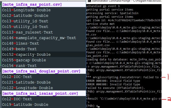
line indicated by -1 shows the original results (when Col1=Longitude Text)
line indicated by -2 shows the results after updating the Latitude and Longitude columns.
note:
double quotes are only used to escape otherwise used column delimiters. i.e. if you have a comma in the column value, you will need to "double quote" it so that it doesn't create an additional column for that row.
- Mark as New
- Bookmark
- Subscribe
- Mute
- Subscribe to RSS Feed
- Permalink
- Report Inappropriate Content
I had the same problem I just want to share my solution.
When I was running the tool MakeXYEvent, I notice that the column Lat and Long are read as Text datatype. But, automatically my Arcgispro creates a new column automatically named Lat_D and Long_D as Double datatype.
So, in the code I just used these new column names. I did not nothing else and now works ok.
Thanks for the comments here everythings helped me to solved it.
- « Previous
-
- 1
- 2
- Next »
- « Previous
-
- 1
- 2
- Next »