- Home
- :
- All Communities
- :
- Products
- :
- ArcGIS Pro
- :
- ArcGIS Pro Questions
- :
- The input path contains spaces glitch in ModelBuil...
- Subscribe to RSS Feed
- Mark Topic as New
- Mark Topic as Read
- Float this Topic for Current User
- Bookmark
- Subscribe
- Mute
- Printer Friendly Page
The input path contains spaces glitch in ModelBuilder
- Mark as New
- Bookmark
- Subscribe
- Mute
- Subscribe to RSS Feed
- Permalink

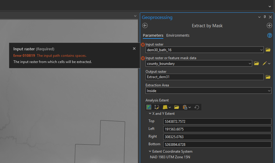
Have run into an error I have never seen before nor have any clue how to resolve at this stage. ModelBuilder is telling me the input dataset I have has spaces in it. As you can see from the screenshot, no it does not.
I have tried to:
- Restart Arc
- Save the model as a new version
- Write the input file to a folder and geodatabase path with no spaces anywhere present
- Change the name of the input dataset on a re-export to a singular word
- Restart my computer
- Uninstall and reinstall ArcPro
All to no avail. Would love guidance, been doing this for 8 years and never seen something like this happen.
- Mark as New
- Bookmark
- Subscribe
- Mute
- Subscribe to RSS Feed
- Permalink
All I can see is the name and not the full path in your screen grab. Can you confirm that the full path is space free
... sort of retired...
- Mark as New
- Bookmark
- Subscribe
- Mute
- Subscribe to RSS Feed
- Permalink
The error is that the path has spaces, not just the filename (which is all that is visible in the screenshot). I see that you said you tried writing the input file to a folder and geodatabase path with no spaces anywhere present - but that is what I would be double checking.
Is there a chance your save location could be specified in different ways (e.g. a mapped network drive)? Is there a way to get ModelBuilder to show the file path in full?
Just generally, this suddenly seems to be an error in 3.4 whereas it was not in earlier versions. Very frustrating!
- Mark as New
- Bookmark
- Subscribe
- Mute
- Subscribe to RSS Feed
- Permalink
I can confirm that there are no spaces in the file path and I had never had this issue before the beginning of March 2025. I have tested this with other rasters saved to C:\Test\nospaces.gdb\rastername
Error still occurs
I have uninstalled and reinstalled ArcPro. Error still occurs. I have updates to the newest version of the software. Error still occurs.
Sometimes, if I open this tool in another ArcPro project, it works just fine - even with filepaths with spaces.
When this problem occurs in ModelBuilder, it also occurs in the Extract by Mask Tool outside of MB. It depends on the day if it wants to behave or not. Incredibly frustrating and I have done everything in my power to fix it - still no luck.
- Mark as New
- Bookmark
- Subscribe
- Mute
- Subscribe to RSS Feed
- Permalink
There are only 7 bugs listed for modelbuilder in arcgispro 3.4
I would contact tech support since they may not have received any reports or they are still assessing it before putting notification on the public facing site.
... sort of retired...
- Mark as New
- Bookmark
- Subscribe
- Mute
- Subscribe to RSS Feed
- Permalink
As you mentioned, this is a wider issue, not just in modelbuilder, but also in geoprocessing toolbox. Here it is replicated with nothing but the input constant 1 for the Con tool in both modelbuilder and geoprocessing:


- Mark as New
- Bookmark
- Subscribe
- Mute
- Subscribe to RSS Feed
- Permalink
Why are you putting a "1" as the start an output name?
This can fail for many reasons, but if the tool doesn't know whether the output raster will be an esri grid or a tiff, it might do the check first and since esri grids cannot begin with a number, it may just throw the closest error in its path.
My recommendation is to click on the folder icon beside the output and input names, from there navigate to the folder or geodatabase where you want your raster to go. The recommended output from esri is to specify outputs as *.tif files in a folder. After selecting the folder, you should be able to enter a filename (not beginning with a number) with a specified file extension (eg *.tif)
Again, recommended practice would be to navigate to and select the destination location, specify the filename with extension ensuring that the output path doesn't contain spaces and the output filename doesn't begin with a number, contain spaces and has a specified file extension (unless you want an old-school esri grid for some reason)
... sort of retired...
- Mark as New
- Bookmark
- Subscribe
- Mute
- Subscribe to RSS Feed
- Permalink
He's not putting a "1" as the start of an output name. He's putting 1 as a constant value. How a constant value has spaces in it is beyond me.
- Mark as New
- Bookmark
- Subscribe
- Mute
- Subscribe to RSS Feed
- Permalink
So is it an esri grid then? And is 'G' a local drive?
Try Copy raster to get it into *.tif format, which is the raster format that esri recommends now
... sort of retired...