- Home
- :
- All Communities
- :
- Products
- :
- ArcGIS Pro
- :
- ArcGIS Pro Questions
- :
- Re: Split polygon tool. Says line doesn't intersec...
- Subscribe to RSS Feed
- Mark Topic as New
- Mark Topic as Read
- Float this Topic for Current User
- Bookmark
- Subscribe
- Mute
- Printer Friendly Page
Split polygon tool. Says line doesn't intersect polygon, but snapping is on and it definitely intersects.
- Mark as New
- Bookmark
- Subscribe
- Mute
- Subscribe to RSS Feed
- Permalink
- Report Inappropriate Content
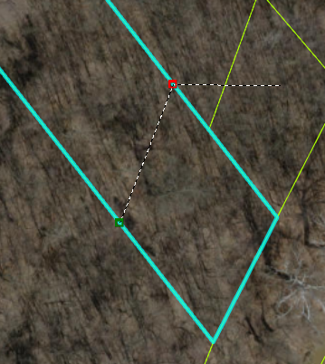
I'm trying to split this polygon about a dozen times. It was working for a while, but eventually it just stopped working. I started getting an error that the lines don't intersect the polygon, but as you can see in the attached photo, it certainly does. Please ignore the tail line outside of the polygon... I was trying to get a screenshot. Snapping is on, and when I hover over the split point, it shows I'm on an edge. How do I fix this? I have tried restarting my computer and ArcGIS.
Thanks.
- Mark as New
- Bookmark
- Subscribe
- Mute
- Subscribe to RSS Feed
- Permalink
- Report Inappropriate Content
Hi Melissa,
That's very odd indeed. I'm trying to reproduce on my end, but I can't. So I have some questions:
- If you add the layer, and only that layer, to a new map, does it still reproduce?
- What coordinate system is the data?
- What coordinate system is the map?
- Are you the only one editing the data?
- What version of Pro are you using?
Thanks,
Scott
- Mark as New
- Bookmark
- Subscribe
- Mute
- Subscribe to RSS Feed
- Permalink
- Report Inappropriate Content
Hi Scott,
Thanks for replying to my question. I was able to make it work by just extending the split line - so that I was clicking outside the polygon on each end instead of just clicking on the polygon edges. Seems obvious now, but I figured it out by accident just clicking around trying to get it to work. That seems to work for now, but to answer your questions:
1. I'm not sure because I got it to work in the other way before I saw your question and already split it.
2. NAD 1983 StatePlane Missouri East FIPS 2401 Feet_1
3. NAD 1983 StatePlane Missouri East FIPS 2401 Feet_1
4. Yes, just me.
5. 2.4.2
- Mark as New
- Bookmark
- Subscribe
- Mute
- Subscribe to RSS Feed
- Permalink
- Report Inappropriate Content
Hi Melissa,
I'm glad you got it to work. Did you have this checked when it was giving the error?
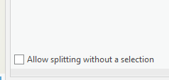
I can be useful to explore what that option does, since the tool will expect different inputs depending on if if is checked. To me, it doesn't sound like this was the issue, but it could be good to know.
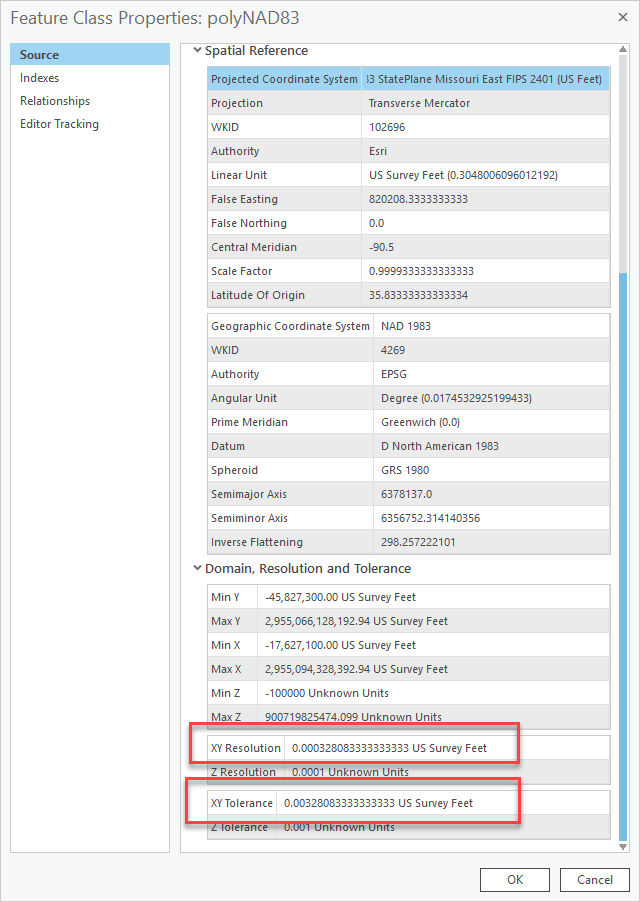
I'm just curious, does your polygon layer use the default XY Resolution and XY Tolerance values for that coordinate system? Here is what the defaults look like for NAD 1983 StatePlane Missouri East FIPS 2401 (US Feet):
Thanks!
Scott