- Home
- :
- All Communities
- :
- Products
- :
- ArcGIS Pro
- :
- ArcGIS Pro Questions
- :
- Re: Pro 3D Map editing issue with Edit Vertices & ...
- Subscribe to RSS Feed
- Mark Topic as New
- Mark Topic as Read
- Float this Topic for Current User
- Bookmark
- Subscribe
- Mute
- Printer Friendly Page
Pro 3D Map editing issue with Edit Vertices & Copy/Paste Multiplying elevations by 3.28
- Mark as New
- Bookmark
- Subscribe
- Mute
- Subscribe to RSS Feed
- Permalink
- Report Inappropriate Content
Good morning
I am running into a weird issue where my map in my Pro Document is displaying Z units in meters. This is despite the fact that I have
- Set my layer properties to US Feet in the Contents Pane.
- I have also set My Map's Properties to be in NGVD 29 so US Survey Feet.
- I have set the Z mode on the Edit Toolbar constant and to be in US Feet.
- I have set the Units in Project Tab under Options for the project to all be in US Feet.
Despite all of this when I create a new polygon, it will create a polygon at the proper elevation in feet but when I edit the vertices it will show the units in meters.... This is weird but it creates a problem when I copy and paste an existing polygon where it multipies the new polygon by 3.28 during the copy/paste operation.
Is there another setting I need to adjust to prevent this from happening and to correctly show the vertices of edited features and Geometry Z-values in English units?
The items I am editing are in GCS WGS84 if that is the issue.
Thanks.
- Mark as New
- Bookmark
- Subscribe
- Mute
- Subscribe to RSS Feed
- Permalink
- Report Inappropriate Content
Hi Robert,
Here is how it works:
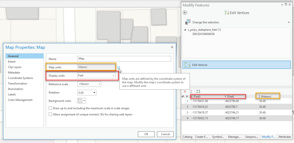
- The Display units that you set in the map properties control the units for X and Y coordinates that you see in the Edit Vertices tool.
- The Map units in the map properties control the units for Z values that you see in the Edit Vertices tool. This is read-only and comes from the map’s coordinate system (see the information bubble in the screenshot below).
- One thing to note: if the layer has a vertical coordinate system defined, then the Z coordinates will derive from its vertical unit. If there isn't a vertical coordinate system defined for the layer, then the Z coordinates will default to the projected coordinate systems vertical unit (which will match the projected coordinate system's linear unit).
In the screenshot below, I’ve tried to illustrate a possible example where the XY units may not match the Z units. In the screenshot, the layer’s XY coordinate system uses feet as the linear unit, so the map’s display units have been set to feet, which controls the XY units in the Edit Vertices tool. The XY coordinate system of the map is WGS 1984 Web Mercator (auxiliary sphere), which uses a linear unit of meters, therefore, the Edit Vertices tool will display Z values in meters:
As far as incorrect z-values when you copy and paste - we are investigating a possible scenario where that could occur. Can you please provide me with more details about the coordinate system(s) (XY and possibly Z) of your layer and the map - as well as information about the map units and display units as discussed above?
EDIT: I know you have provided some information already, but perhaps some screenshots of the map's properties General tab and Coordinate System tab, as well as the layer's coordinate system tab will help.
Thank you,
Scott
- Mark as New
- Bookmark
- Subscribe
- Mute
- Subscribe to RSS Feed
- Permalink
- Report Inappropriate Content
Good afternoon. I just replied back to Michael Contreras and will get him the files thru DoD Safe. I am fairly certain my Z units of the underlying data is set in ft. in both map and scene. The underlying data is in WGS84 which may be where I am getting off track. I am sending the files to Michael Contreras now. Thanks.