- Home
- :
- All Communities
- :
- Products
- :
- ArcGIS Pro
- :
- ArcGIS Pro Questions
- :
- Re: Ortho Mapping - errors when creating workspace
- Subscribe to RSS Feed
- Mark Topic as New
- Mark Topic as Read
- Float this Topic for Current User
- Bookmark
- Subscribe
- Mute
- Printer Friendly Page
Ortho Mapping - errors when creating workspace
- Mark as New
- Bookmark
- Subscribe
- Mute
- Subscribe to RSS Feed
- Permalink
- Report Inappropriate Content
Hi all.
Am having my first play with the 'Ortho Mapping' within ArcGIS Pro 1.4. I have some UAV photos captured using a Phantom 4.
I clicked new workspace, entered a name etc, then selected the folder where the photos were located. It successfully detected the geolocation data within the imagery and the spatial reference. I didn't change any parameters, just left everything as default, then I clicked next. It began to create the workspace and a log page appears.
However, here something goes wrong - it begins to spit out errors, looks like they are repeated once for each photo. I have pasted below the error messages. I'd be interested to know if anyone else has experienced this or knows what is happening here and how to fix whatever's going wrong.
Cheers,
-Paul
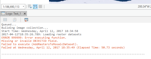
Queued...
Building image collection...
Start Time: Saturday, 25 March 2017 5:31:24 PM
2017-03-25T17:31:28.826: Loading raster datasets
2017-03-25T17:31:28.972: Completed crawling 573 data source items. Added 573 mosaic dataset items.
2017-03-25T17:31:28.978: Synchronizing crawled data source items
2017-03-25T17:31:29.021: Synchronizing items associated with raster type instance 'UAV/UAS' [ID: 1].
2017-03-25T17:31:29.043: Distributing mosaic dataset operation across 2 parallel instances on the specified host: [LAPTOP-8A254KAB].
2017-03-25T17:31:38.992: Error: 8004206c: Failures reported while processing specified command item. [1]
2017-03-25T17:31:39.002: Error: 80042019: Chained Error ID: 0X80042019
2017-03-25T17:31:39.010: Error: 80042019: Could not build mosaic dataset item. [ID: 1, URI: 'C:\Oskat\photos\DJI_0397.JPG']
2017-03-25T17:31:39.019: Error: 8004103f: Creation of frame camera model failed.
2017-03-25T17:31:39.039: Error: 8004206c: Failures reported while processing specified command item. [2]
2017-03-25T17:31:39.050: Error: 80042019: Chained Error ID: 0X80042019
2017-03-25T17:31:39.059: Error: 80042019: Could not build mosaic dataset item. [ID: 2, URI: 'C:\Oskat\photos\DJI_0398.JPG']
2017-03-25T17:31:39.067: Error: 8004103f: Creation of frame camera model failed.
etc, etc until the end:
2017-03-25T17:33:24.335: Error: 8004206c: Failures reported while processing specified command item. [200]
2017-03-25T17:33:24.345: Error: 80042019: Chained Error ID: 0X80042019
2017-03-25T17:33:24.357: Error: 80042019: Could not build mosaic dataset item. [ID: 200, URI: 'C:\Oskat\photos\DJI_0596.JPG']
2017-03-25T17:33:24.363: Error: 8004103f: Creation of frame camera model failed.
2017-03-25T17:33:24.558: Error: 8004205e: 573 mosaic dataset items could not be built.
2017-03-25T17:33:24.706: Removing invalid mosaic dataset items
2017-03-25T17:33:24.999: Removing unreferenced raster type and overview instances
2017-03-25T17:33:25.011: Removed 573 mosaic dataset items and 1 unreferenced raster type instances.
2017-03-25T17:33:25.270: Removing broken mosaic dataset items.
2017-03-25T17:33:25.499: Removed 0 mosaic dataset items and 0 unreferenced raster type instances.
2017-03-25T17:33:25.685: Completed synchronization: 573 items selected, 0 items synchronized.
ERROR 999999: Error executing function.
Failed to execute (AddRastersToMosaicDataset).
Failed at Saturday, 25 March 2017 5:33:30 PM (Elapsed Time: 2 minutes 5 seconds)
- Mark as New
- Bookmark
- Subscribe
- Mute
- Subscribe to RSS Feed
- Permalink
- Report Inappropriate Content
Please double check the Camera Parameters. Make sure focal length, pixel size, columns and rows are correct.
- Mark as New
- Bookmark
- Subscribe
- Mute
- Subscribe to RSS Feed
- Permalink
- Report Inappropriate Content
I'm also having a problem building my ortho workspace. ArcGIS Pro is refusing to add my imagery to a mosaic dataset that is part of the process. I'm using Ultracam 20cm with EO & IO Parameters defined using a .csv.
Here is a screen shot of my error:
- Mark as New
- Bookmark
- Subscribe
- Mute
- Subscribe to RSS Feed
- Permalink
- Report Inappropriate Content
Hi Kevin,
It seems the Parameters didn’t be got correctly. Please double check the image location (GPS) and Camera parameters.
If possible, please share me some images and the .csv file.
Thanks,
Mingzhen
- Mark as New
- Bookmark
- Subscribe
- Mute
- Subscribe to RSS Feed
- Permalink
- Report Inappropriate Content
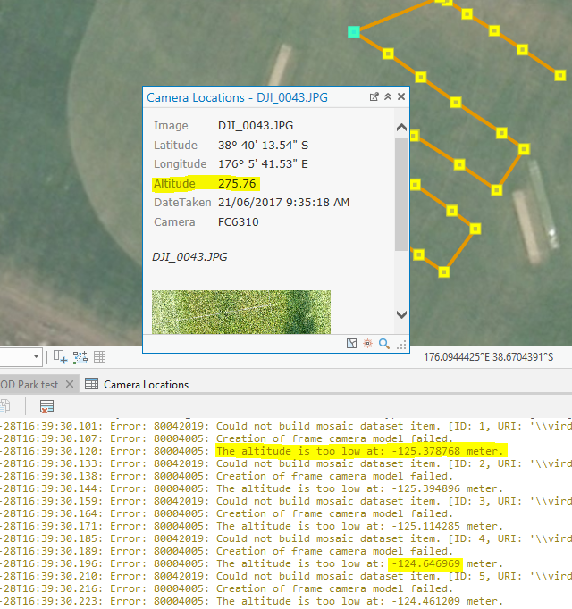
I've just upgraded to Pro 2.0 and I am still getting error messages when I try to OrthoMap.
2.0 brings the addition of another error 80004005 which is telling me that the altitude is to low. However I don't understand how they get an altitude of -125m/-124m when the details on the pop-up clearly state that the altitude is 275.76.
- Mark as New
- Bookmark
- Subscribe
- Mute
- Subscribe to RSS Feed
- Permalink
- Report Inappropriate Content
What is the elevation of working area? If the elevation is larger than GPS altitude (e.g. 275.76), it will cause the problem.
- Mark as New
- Bookmark
- Subscribe
- Mute
- Subscribe to RSS Feed
- Permalink
- Report Inappropriate Content
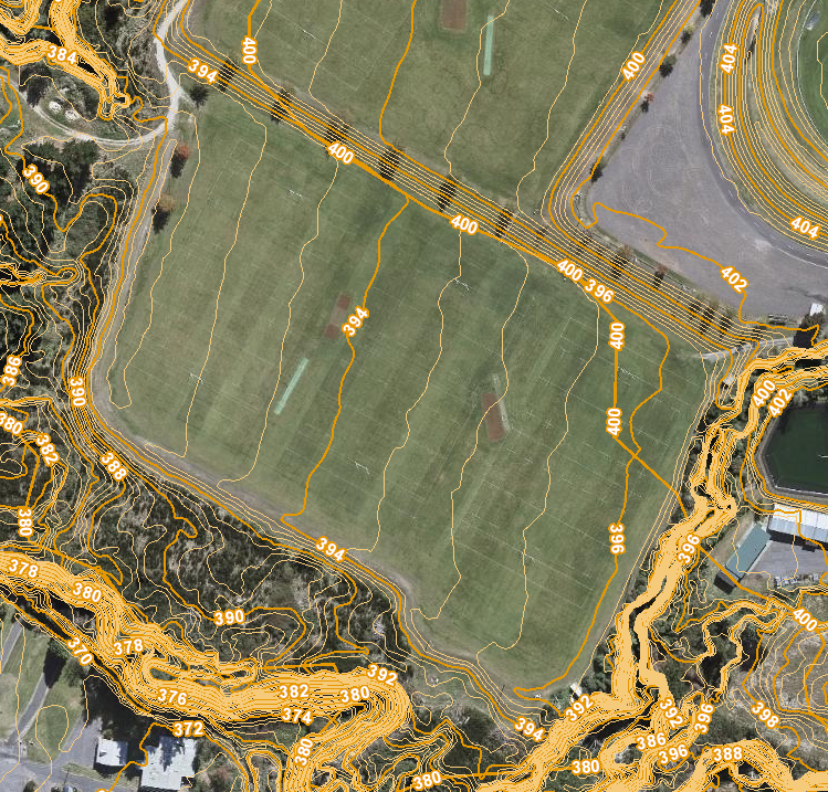
Here are our contours for that area. Approximately 394m.
- Mark as New
- Bookmark
- Subscribe
- Mute
- Subscribe to RSS Feed
- Permalink
- Report Inappropriate Content
It seems the GPS altitude (e.g. 275.76) is not the elevation. Please try using constant Elevation 0 as DEM.
- Mark as New
- Bookmark
- Subscribe
- Mute
- Subscribe to RSS Feed
- Permalink
- Report Inappropriate Content
I have the same issue. I ran it with constant elevation of 0 and still no dice. Even if that was the case, flying at different elevations and flying oblique are essential to good 3D modeling.
- Mark as New
- Bookmark
- Subscribe
- Mute
- Subscribe to RSS Feed
- Permalink
- Report Inappropriate Content
This is a dated response, but did you ever get a resolution to the Altitude issue when making a workspace with Drone imagery? I have the same model and errors as you do.
- Mark as New
- Bookmark
- Subscribe
- Mute
- Subscribe to RSS Feed
- Permalink
- Report Inappropriate Content
It appears that the software is misreading the exif metadata on the images themselves. I have a similar issue with Pro v2.2.4 and tested Desktop's method of creating a raster mosaic using the UAV/UAS parameter.
Below is a snip of the Camera Locations table created from the Pro Orthomapping tool. Currently the only way I have found to workaround is to set a static flight height for all images.
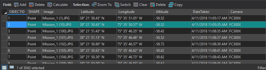
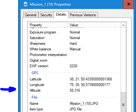
Below is a snip of the above highlighted records metadata in the image. Notice the Altitude value here is not negative.
There is some kind of issue with parsing the metadata and a simple fix would be to get the absolute value of the element.