- Home
- :
- All Communities
- :
- Products
- :
- ArcGIS Pro
- :
- ArcGIS Pro Questions
- :
- Re: Labelling woes... (in Pro or in ArcMap)
- Subscribe to RSS Feed
- Mark Topic as New
- Mark Topic as Read
- Float this Topic for Current User
- Bookmark
- Subscribe
- Mute
- Printer Friendly Page
Labelling woes... (in Pro or in ArcMap)
- Mark as New
- Bookmark
- Subscribe
- Mute
- Subscribe to RSS Feed
- Permalink
- Report Inappropriate Content
I am not sure there is an "easy" answer to this but I have given up and am relying on GeoNet to pull me out of a jam.
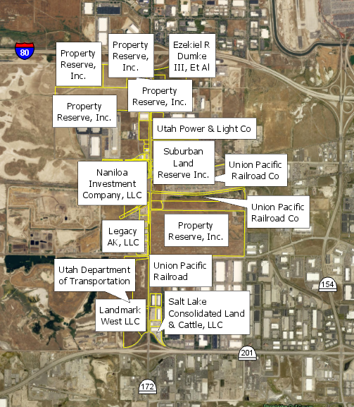
Is there an "easy button" for labelling just the way I want it? Here are about 66 polygons that need labels visible for each one and need to see the polygon. In Pro, this is how they look without much change in the properties:
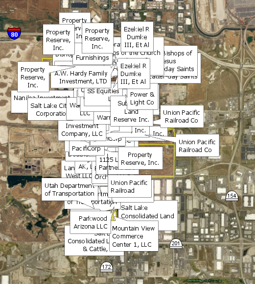
I want to see all the labels so I choose Never remove. This is what I get:
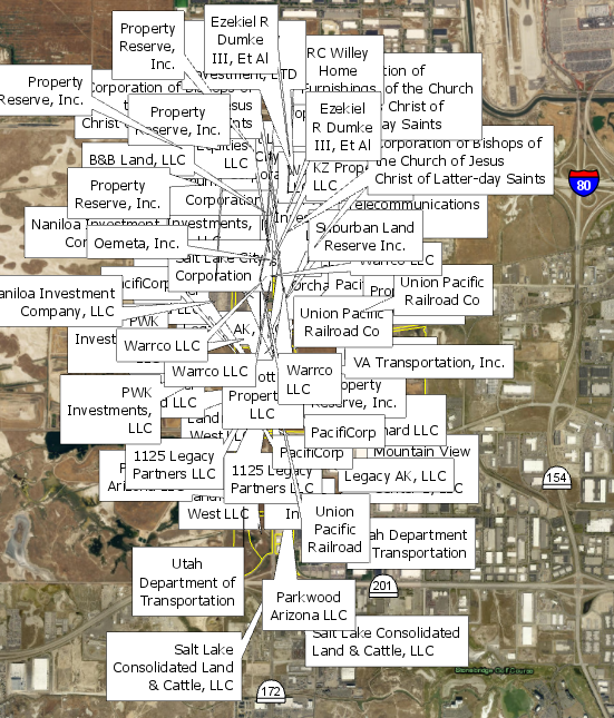
Even if I throw in a 50 point offset, 200 point max overrun, 50% buffer, 100 point feature weight to interior and boundary features (and other tweaks), this is my result:
Is there some sort of magic button that will not allow labels to overlap each other? I have attempted to mess around with all of the settings in the label properties and have not come up with a good solution (I do have Maplex Label Engine turned on). My best bet is to convert to annotations and move them that way, manually, by hand, one at a time. (small snippet: 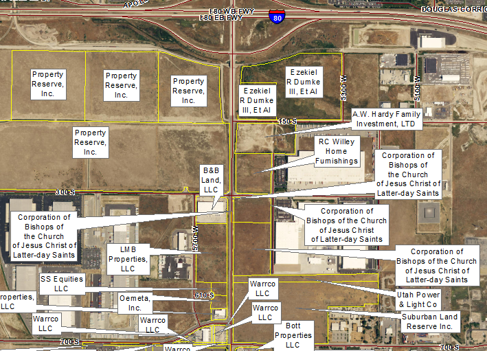 )
)
I keep thinking I'm missing something super obvious. Tell me where I can find the easy button (in ArcGIS Pro preferably or ArcMap - it doesn't matter). Thanks!
- Mark as New
- Bookmark
- Subscribe
- Mute
- Subscribe to RSS Feed
- Permalink
- Report Inappropriate Content
Phew that sounds A LOT of work to do but for my project I think I have other ideas....
What I would do is to juggle between Label Manager and Annotation..
So you have labels that are overlaps, what I would do is to define a new class just for those overlaps in Label Manager and then use the SQL to define these that are overlaps. Then you can convert it to Annotation and fix it and move it around a little bit ... This is a good one ONLY if you have a small project area like mine... just the thought ...
- Mark as New
- Bookmark
- Subscribe
- Mute
- Subscribe to RSS Feed
- Permalink
- Report Inappropriate Content
It does sound like a lot of work. When you have your original label class with unplaced labels you can convert it over to annotation and specify that the unplaced labels are converted to annotation at that time. No need for another label class to store them in.
Once you have the annotation you can go into the symbology and specify to draw the unplaced annotation so you can see it and then place it from there. In the attribute table there is a field that specifies whether the anno is placed or unplaced which makes it easy to query on and then zoom to each area - no need to go searching on your own.
You can do all of this in both ArcMap and Pro.
I hope this helps
Wendy
- Mark as New
- Bookmark
- Subscribe
- Mute
- Subscribe to RSS Feed
- Permalink
- Report Inappropriate Content
Thank you. That explains clearly. I need to do this...
- Mark as New
- Bookmark
- Subscribe
- Mute
- Subscribe to RSS Feed
- Permalink
- Report Inappropriate Content
Is it possible to set a zoom extent on the visibility of the labels so you have to zoom in instead to see each label better?
- Mark as New
- Bookmark
- Subscribe
- Mute
- Subscribe to RSS Feed
- Permalink
- Report Inappropriate Content
Matt,
If you are referring to the scale dependency of labels, you can do that. Take a look here:
It states:
Set scale ranges for label classes
Some labels are most useful within a given scale range. For example, on a city map, a label class of all street names might be useful up to some minimum scale. As you zoom out beyond that scale, the labels would become too crowded—or too small if there is a reference scale set—and you may prefer to display a label class that only shows major street names.
Setting a minimum scale for labels can improve the overall redraw performance of your map, making panning and zooming more responsive, as labels are only drawn within the scale range at which they're useful. You can set the minimum and maximum scales in the Visibility Range group on the Labeling tab or on the Visibility Range tab of the Label Class pane. If no scale is set, the labels will have the same scale range as the feature layer.
- Mark as New
- Bookmark
- Subscribe
- Mute
- Subscribe to RSS Feed
- Permalink
- Report Inappropriate Content
Would that work in ArcMap ? I have use Pro but I am entirely focus at ArcMap 10.5.1 right now.
- Mark as New
- Bookmark
- Subscribe
- Mute
- Subscribe to RSS Feed
- Permalink
- Report Inappropriate Content
Hi Robert,
Yes you can do this in ArcMap as well
Setting scale ranges for label classes—Help | ArcGIS Desktop
Wendy
- Mark as New
- Bookmark
- Subscribe
- Mute
- Subscribe to RSS Feed
- Permalink
- Report Inappropriate Content
I'm just thoroughly impressed you figured out how to do call outs with leader lines. I can't figure that out in ArcPro at all. Used to be something ridiculously easy in ArcMap and now it's buried somewhere damn near impossible to find it seems.
- Mark as New
- Bookmark
- Subscribe
- Mute
- Subscribe to RSS Feed
- Permalink
- Report Inappropriate Content
Rob,
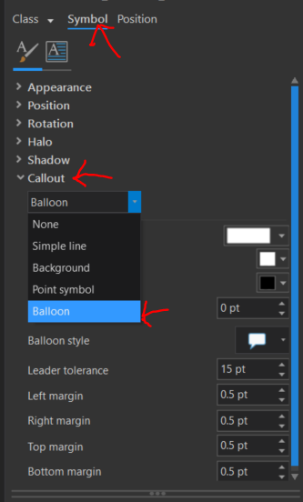
Once you work through the different docking panes in Pro, you start to get the hang of how to do the labeling and other techniques. For callouts with leader lines, just to the layer's labeling properties, click on Symbol, then Callout, drop the box down to Balloon and mess with the properties from there.
- « Previous
- Next »
- « Previous
- Next »