- Home
- :
- All Communities
- :
- Products
- :
- ArcGIS Pro
- :
- ArcGIS Pro Questions
- :
- Image envelopes appearing in prints from PDF creat...
- Subscribe to RSS Feed
- Mark Topic as New
- Mark Topic as Read
- Float this Topic for Current User
- Bookmark
- Subscribe
- Mute
- Printer Friendly Page
Image envelopes appearing in prints from PDF created with ArcGIS Pro
- Mark as New
- Bookmark
- Subscribe
- Mute
- Subscribe to RSS Feed
- Permalink
- Report Inappropriate Content
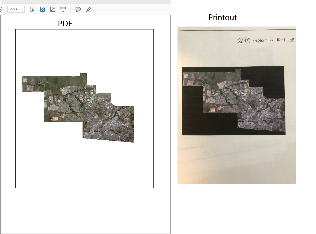
I am experiencing an issue with ArcGIS Pro and it doesn't seem specific to a version as I have reproduced it with both ArcGIS Pro 2.5 and 2.7.
When creating maps with an aerial photo backdrop (not an Esri basemap in this case) then exporting to PDF the result looks great and comparable to one produced in ArcMap 10.4.1. However when I print both maps the one created in ArcGIS Pro displays an solid rectangular black box representing the image envelope that becomes visible in print (see attached). I tried a number of things to try and fix this, including a quick test with a simple image in map frame and switching the raster image from a 10.4.1 sde geodatabase to a .sid image to see if this might be due to Pro having trouble reading from our admittedly older geodatbase. The .sid gives a slightly different result (hollow black envelop box) and it is also somewhat visible in the PDF too as I have pointed out in the attached images.
I should mention I have found that if I check the output as image button in the Export dialog this seems to solve it and the envelop goes away which is great, but this is only a workaround as there may be cases where we need to keep the PDF layers intact, text searchable etc. Also it seems there are a lot of people commenting on another thread related to transparent images producing lines in the PDF which is not the issue I am having for some reason. I get the same result whether or not my aerial image is set to transparent.
My current export settings are below, but I have tried a lot of different combinations and I was curious if anyone else is having these issues and/or knows how to fix this.
File type: PDF
Compression: JPG
Quality: Default 80%
Compress Vector Graphics: checked
Resolution: 300dpi
Raster Resample: 1:3 (Normal)
Layers and attributes: PDF Layers Only
Color Management: Embed color profile checked
- Mark as New
- Bookmark
- Subscribe
- Mute
- Subscribe to RSS Feed
- Permalink
- Report Inappropriate Content
Interesting. There are 2 related bugs that discuss this behavior but it appears when a transparency is set.
- BUG-000127781: When a basemap is exported with resolutions above 150 DPI to PDF with a transparency value set in ArcGIS Pro, grid lines appear when opening the file in a PDF software, such as Adobe Acrobat Reader. [NEW]
- BUG-000095765: When a map with a transparency value set for the imagery basemap is exported, grid lines appear in the image at a resolutions above 200 DPI for the PDF format. [CLOSED]
But you mentioned that you are not using a transparency. You do have a less than ideal workaround with the "output as image" button. One thing to try is to set your DPI to less than 200 DPI and see if the black line appears on the printout. What is the result?
- Mark as New
- Bookmark
- Subscribe
- Mute
- Subscribe to RSS Feed
- Permalink
- Report Inappropriate Content
Hi Robert, and thanks for your reply and suggestion.
Yes for me this happens without using any transparency on the raster. I tried your suggestion of lowering the DPI (I went to 150 DPI) but this did not have any improvement in what I am seeing. The envelop border of the .sid image layout still shows up in the PDF layout (partially) and the print (completely) and while the PDF with the sde image doesn't show any border I still get the black envelope in the print unfortunately.