- Home
- :
- All Communities
- :
- Products
- :
- ArcGIS Pro
- :
- ArcGIS Pro Questions
- :
- How to “clear” the coordinate system of the “Map” ...
- Subscribe to RSS Feed
- Mark Topic as New
- Mark Topic as Read
- Float this Topic for Current User
- Bookmark
- Subscribe
- Mute
- Printer Friendly Page
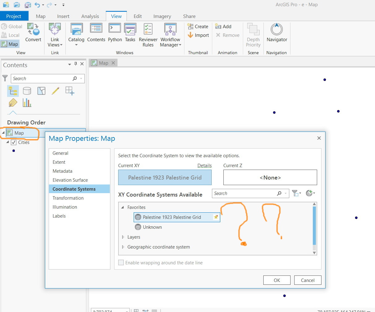
How to “clear” the coordinate system of the “Map” to get it to “unknown” in ArcGIS Pro,
- Mark as New
- Bookmark
- Subscribe
- Mute
- Subscribe to RSS Feed
- Permalink
- Report Inappropriate Content
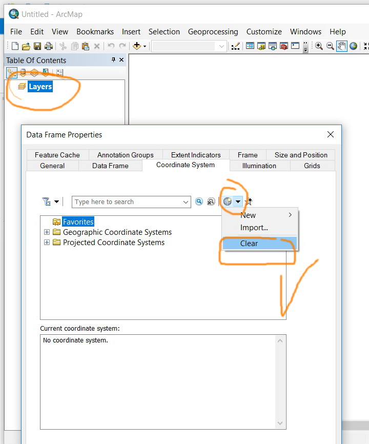
How to “clear” the coordinate system of the “Map” to get it to “unknown” in ArcGIS Pro,
For example, in ArcMap, the clear option is available and one can set the “data frame” to unknown. I couldn’t figure out how to “clear” the coordinate system of the “Map” to get it to “unknown” in ArcGIS Pro as this option is not there
Jamal Numan
Geomolg Geoportal for Spatial Information
Ramallah, West Bank, Palestine
- Mark as New
- Bookmark
- Subscribe
- Mute
- Subscribe to RSS Feed
- Permalink
- Report Inappropriate Content
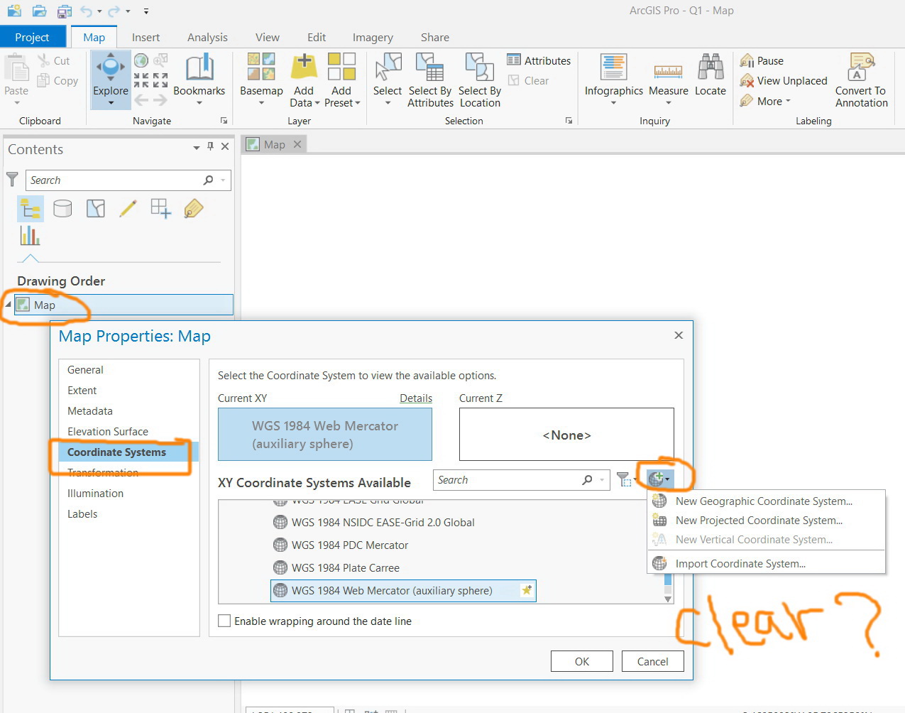
I suppose there is a reason for that. You are not supposed to set the coordinate system to Unknown. I really would like to know why you would want this...
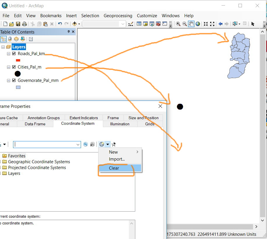
Below a method to accomplish this, but I urge you not to since it is not a good practice to work with the Unknown coordinate system:
- Add a layer with Unknown coordinate system to ArcGIS Pro
- As shown below, expand the coordinate systems of the Layers and you can add the Unknown coordinate system to your favorites. Now it will always be available to select.
- Mark as New
- Bookmark
- Subscribe
- Mute
- Subscribe to RSS Feed
- Permalink
- Report Inappropriate Content
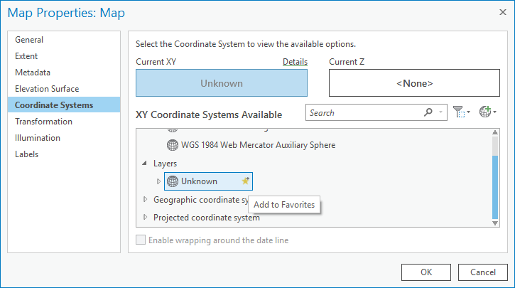
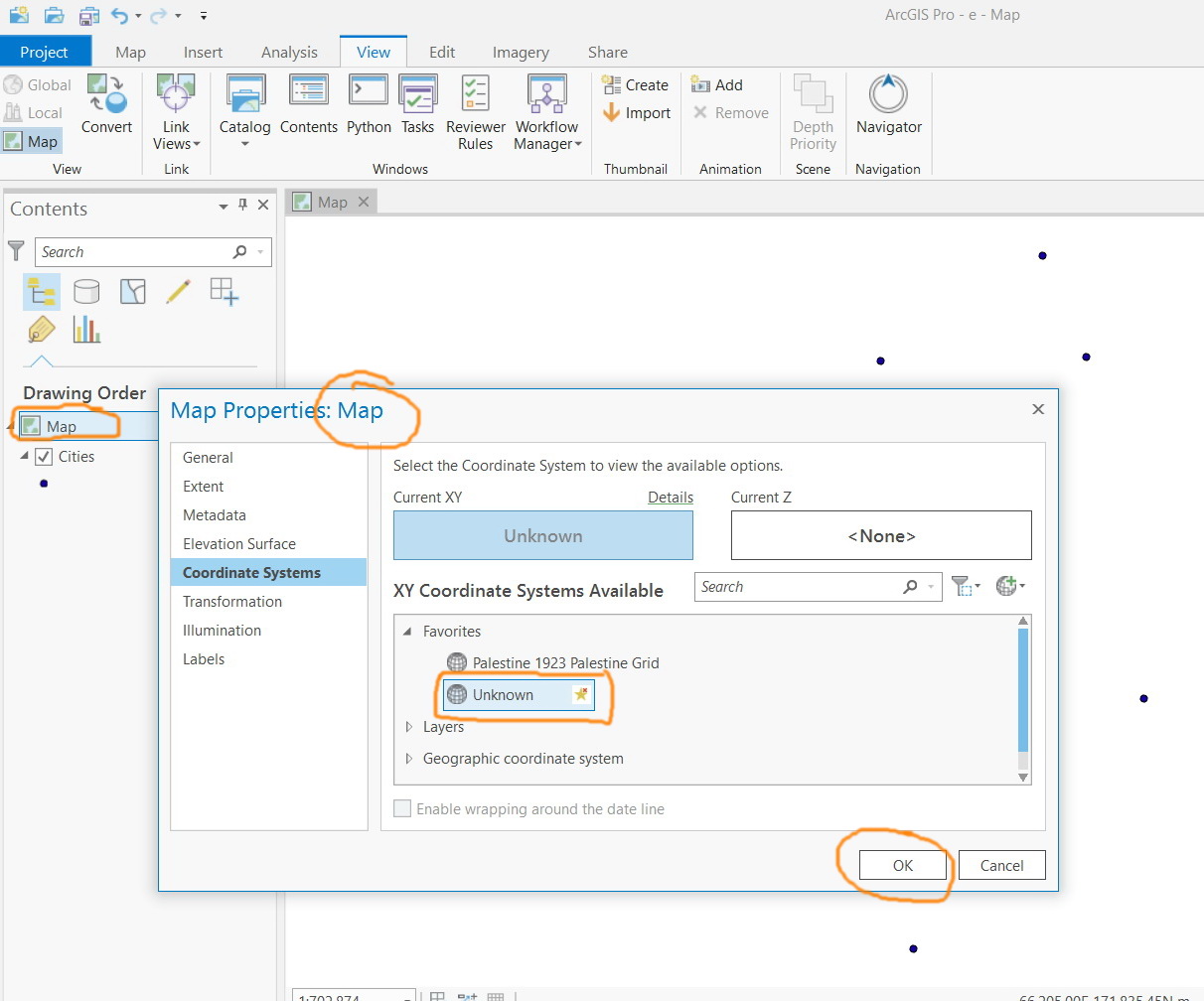
It appears that Pro fails to take the “unknown” coordinate system. As it is selected, it gets back to the previous coordinate system (as shown in the screenshots below).
What could be the issue here?
Jamal Numan
Geomolg Geoportal for Spatial Information
Ramallah, West Bank, Palestine
- Mark as New
- Bookmark
- Subscribe
- Mute
- Subscribe to RSS Feed
- Permalink
- Report Inappropriate Content
I assigned Unknown when I had no information (even no base map) in my map. Probably the reason that you cannot set it is due to the information that you have in your map. Another indication that you shouldn't be doing this.
- Mark as New
- Bookmark
- Subscribe
- Mute
- Subscribe to RSS Feed
- Permalink
- Report Inappropriate Content
There are lots of reasons not to perpetuate 'unknown' coordinate systems
- http://pro.arcgis.com/en/pro-app/help/sharing/analyzer-error-messages/00047-layer-s-dataset-is-using...
- http://pro.arcgis.com/en/pro-app/help/sharing/analyzer-error-messages/00154-layer-s-map-is-using-an-...
- http://pro.arcgis.com/en/pro-app/tool-reference/tool-errors-and-warnings/030001-040000/tool-errors-a...
I could provide more, but there is no good reason to provide an unknown coordinate system when working with spatial data, just lots of bad ones. If the coordinates are using a 'relative coordinate system' you can still tie them into know data.
- Mark as New
- Bookmark
- Subscribe
- Mute
- Subscribe to RSS Feed
- Permalink
- Report Inappropriate Content
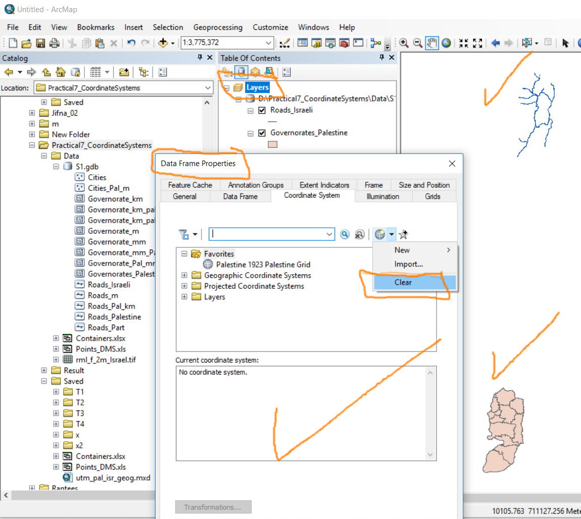
It appears that our life gets hard without “clear” option. Clearing the coordinate system of data frame or layers helps us understand the data we receive. It is very common in our environment to receive data with unknown coordinate system, then the fist step is to investigate the data and then to assign the proper coordinate system.
For example, clearing the coordinate system of the data frame brings the layer to their absolute location and thus we understand how they are different from one another.
Jamal Numan
Geomolg Geoportal for Spatial Information
Ramallah, West Bank, Palestine
- Mark as New
- Bookmark
- Subscribe
- Mute
- Subscribe to RSS Feed
- Permalink
- Report Inappropriate Content
As long as you put a layer into an empty map (dataframe) you will know what it is or isn't
The first layer added sets it, unless it is set before hand.
The problem arises when people add other data first.
The simplest solution is to explore the properties before hand using python and arcpy in a script devised to examine data before it is even used or brought into arcmap or pro.
- Mark as New
- Bookmark
- Subscribe
- Mute
- Subscribe to RSS Feed
- Permalink
- Report Inappropriate Content
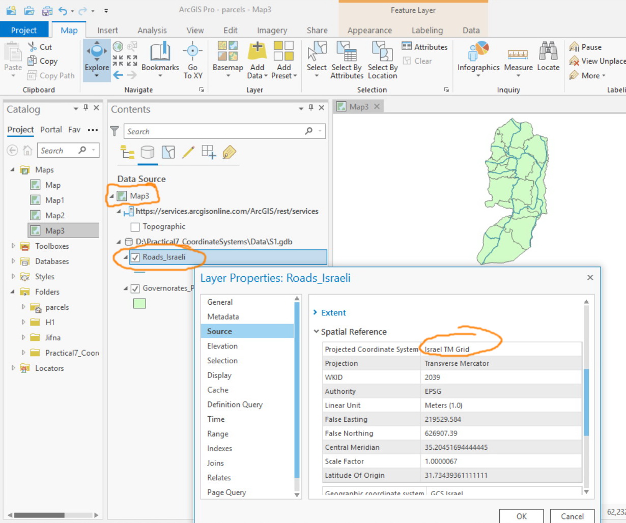
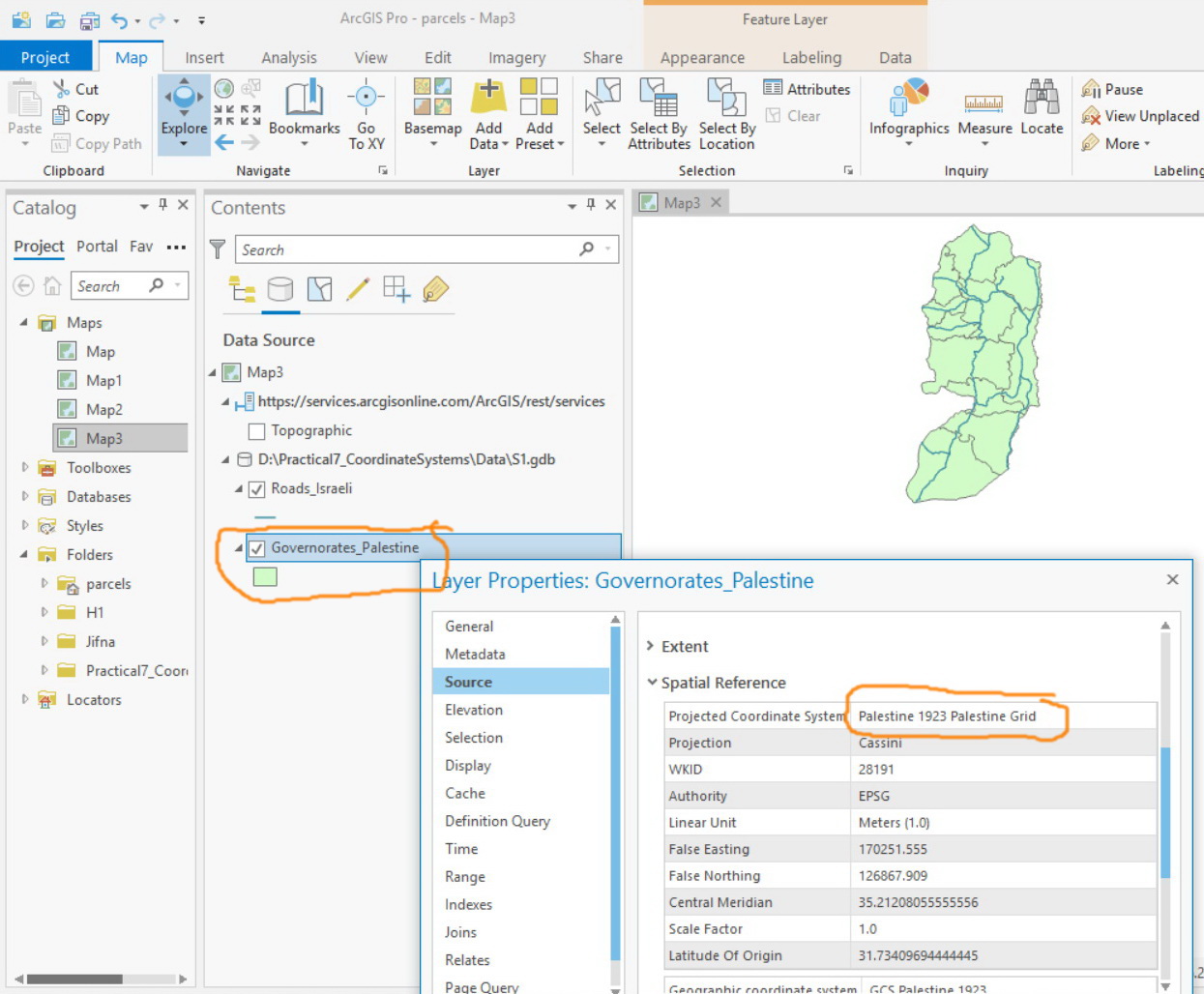
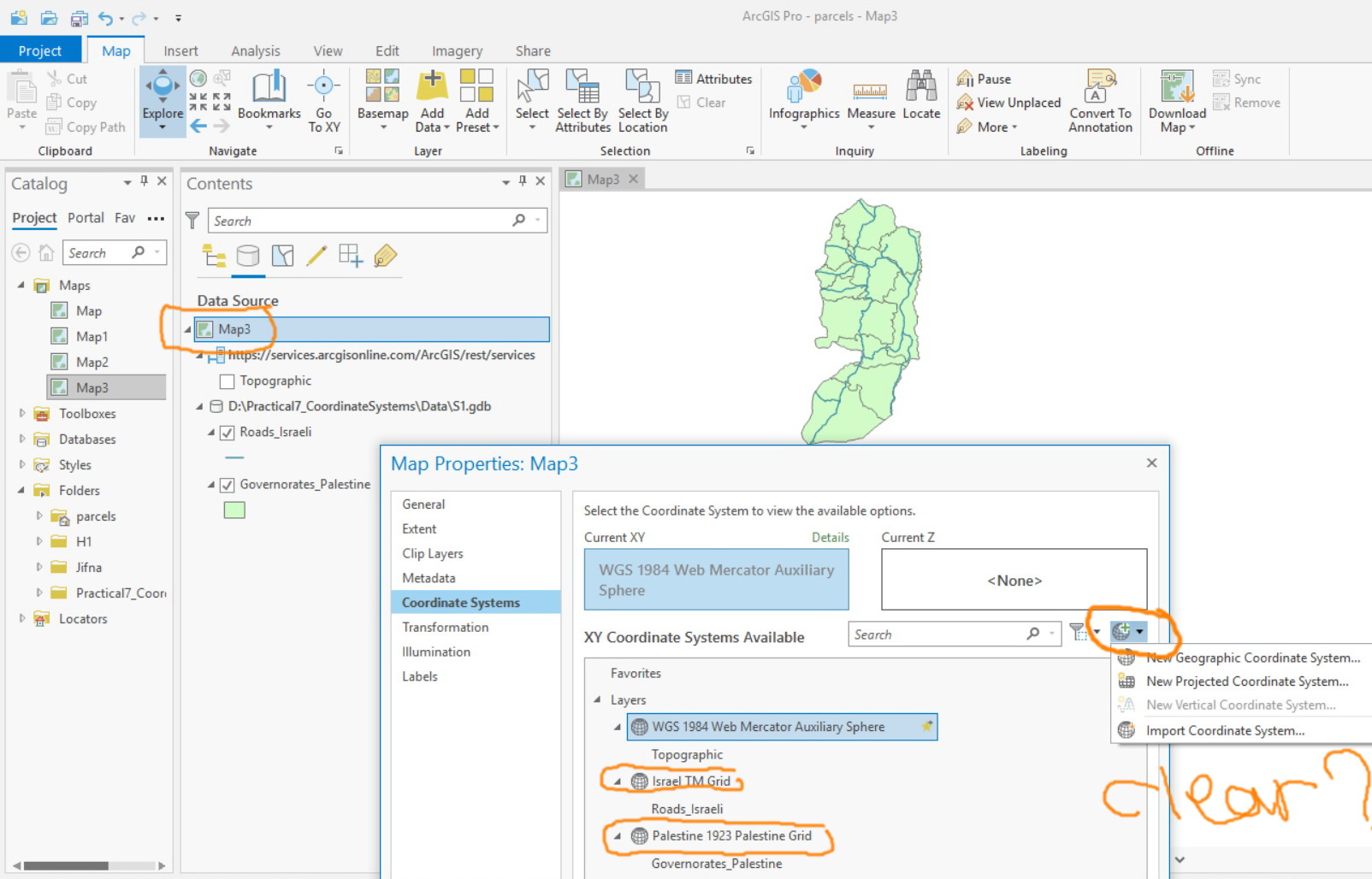
This appears not to be fixed even in 2.3. “clear” tool is not there!
Why do I need it?
In the screenshot below, I have two layers, on in ITM coordinates and the second is in Palestine 1923 Grid. Now, how can I clear the coordinate of the map (data frame), so that I can see these two layers in their absolute values (as it is used to be performed in ArcMap since ages!)
I would love if this tool gets back!
Jamal Numan
Geomolg Geoportal for Spatial Information
Ramallah, West Bank, Palestine
- Mark as New
- Bookmark
- Subscribe
- Mute
- Subscribe to RSS Feed
- Permalink
- Report Inappropriate Content
Jamal, thank you for starting this discussion.
Dan, I appreciate your comments on this post, as i have the same questions as Jamal. I use the 'clear projection' as a stop gap measure to prevent 'projecting on the fly' in ArcMap, almost identically to how Jamal uses it.
My concern is how ArcPro knows which projection to use for the layer. If the projection (or coordinate system) is defined incorrectly, how would ArcPro know? Where would it 'put' the data in space?
It sounds as though it would project on the fly, to the incorrect coordinate system?
Agreed that determining the actual coordinate system ahead of using the data is the best approach. I do so, and direct my students to do so, however, this 'clearing of the projection on the fly' is a good stop gap measure to ensure that the data is lining up.
Thoughts?
- Mark as New
- Bookmark
- Subscribe
- Mute
- Subscribe to RSS Feed
- Permalink
- Report Inappropriate Content
Gregory... When I am using someone else's data, I actually follow the advice given in the previous threads.
I don't like to rely on stop gaps or anything else.
In fact, I still think projection on the fly was a bad idea when it was introduced.
At least in old-school arcview 2/3.x, when you data "didn't line-up" you knew that you were dealing with unknown or incorrectly defined coordinate systems.
People waste more time trying to figure out why subsequent processes don't work properly than they would by getting the data into the necessary and the same coordinate system to begin with. Storage is cheap. I keep my data in geographic and projected coordinates and I use the form appropriate for the task