- Home
- :
- All Communities
- :
- Products
- :
- ArcGIS Pro
- :
- ArcGIS Pro Questions
- :
- Re: How to Calculate a percentage of wetlands in a...
- Subscribe to RSS Feed
- Mark Topic as New
- Mark Topic as Read
- Float this Topic for Current User
- Bookmark
- Subscribe
- Mute
- Printer Friendly Page
How to Calculate a percentage of wetlands in a parcel
- Mark as New
- Bookmark
- Subscribe
- Mute
- Subscribe to RSS Feed
- Permalink
- Report Inappropriate Content
Hello,
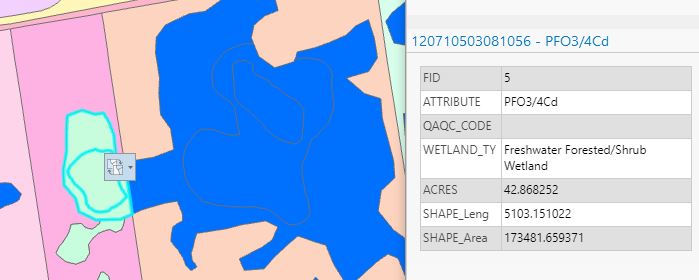
I am working on a project that involves me calculating the amount of wetlands that take up a census block. I was wondering if there is a streamlined way to calculate the wetland area in a block. In my attempts I have been able to isolate pieces of a wetland inside a block but because the wetland shape extends outside the block it reports the acres of the parent wetland. The attached picture shows my issue. I was able to isolate the wetland in green, but when i want to see the acreage, it reports the acres of the blue polygon in the adjacent block. If anyone has any kind of direction to assist me, it would be greatly appreciated!
Solved! Go to Solution.
Accepted Solutions
- Mark as New
- Bookmark
- Subscribe
- Mute
- Subscribe to RSS Feed
- Permalink
- Report Inappropriate Content
Add a new field to your block polygon(s) called Original area and calculate to equal the Shape Area field. Then perform an intersection of your wetlands and your block polygons. You know can compare the original area with the current area (OrginalArea divided by current Shape Area).
- Mark as New
- Bookmark
- Subscribe
- Mute
- Subscribe to RSS Feed
- Permalink
- Report Inappropriate Content
perhaps Tabulate Intersection (Analysis)—ArcGIS Pro | Documentation
... sort of retired...
- Mark as New
- Bookmark
- Subscribe
- Mute
- Subscribe to RSS Feed
- Permalink
- Report Inappropriate Content
In addition to Joe's and Dan's response, be sure to pick a projected coordinate system that preserves area as this could skew your area calculations if the incorrect projected coordinate system is chosen.
- Mark as New
- Bookmark
- Subscribe
- Mute
- Subscribe to RSS Feed
- Permalink
- Report Inappropriate Content
And in addition to us alll. If you have selections made, only the selected features will be processed which is useful if you only have a few to do 😂
... sort of retired...