- Home
- :
- All Communities
- :
- Products
- :
- ArcGIS Pro
- :
- ArcGIS Pro Questions
- :
- Re: How do I remove the 180th meridian line on my ...
- Subscribe to RSS Feed
- Mark Topic as New
- Mark Topic as Read
- Float this Topic for Current User
- Bookmark
- Subscribe
- Mute
- Printer Friendly Page
How do I remove the 180th meridian line on my map of Russia?
- Mark as New
- Bookmark
- Subscribe
- Mute
- Subscribe to RSS Feed
- Permalink
- Report Inappropriate Content
I'm not sure how to remove the line that represents the 180th meridian (international dateline) on my polygon. I have the "Russia Country Boundary 2017" feature layer added from the Living Atlas. My Projected Coordinate System is set to "Asia North Albers Equal Area Conic". I've tried to google this question, but I haven't come across an answer I can fully understand. I'm a student and very new to all this!
Thank you!
The line is actually a gap between the polygons.
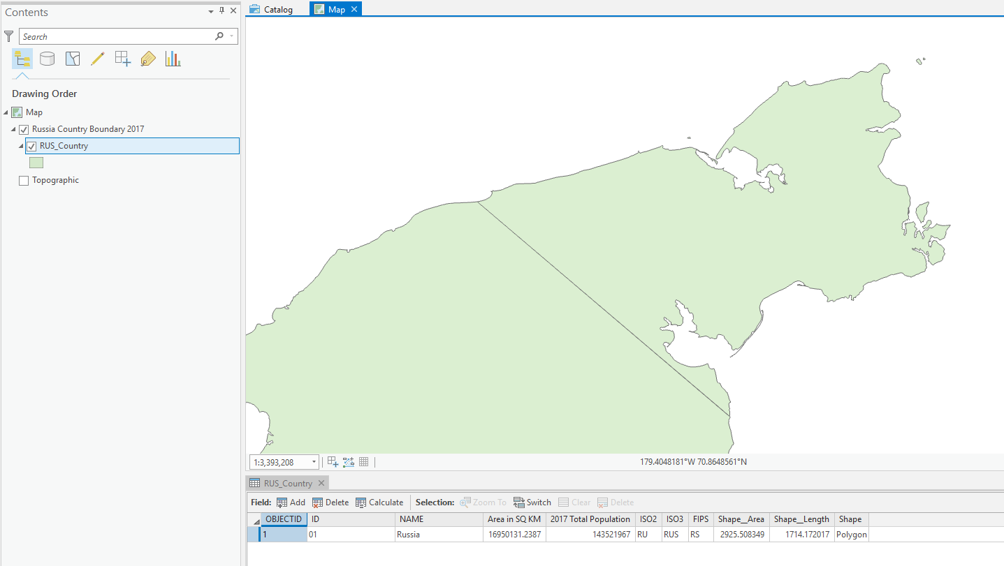
Using ArcGIS Pro 2.3.1
ANSWER:
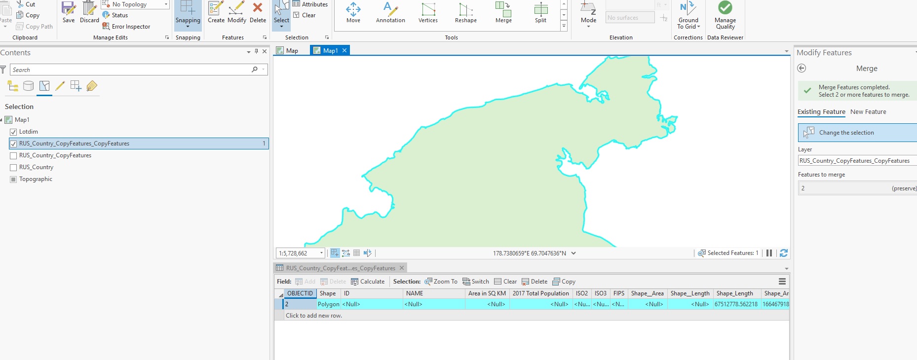
Thanks to everyone below, it turns out I was not projecting correctly, which was creating issues down the line when editing polygons. Here's what I did...
- Start a blank project in ArcGIS. Insert new map, go into its properties, change the Coordinate System to "Asia North Albers Equal Area Conic".
- Add "World Countries (Generalized)" from the Living Atlas. Select Russia and Export Features to new feature class layer.
- Search and select the Project tool from Analysis>Geoprocessing>Tools.
- Select the Russia layer for input. Select "Current Map" for Output Coordinate System. Run.
- Now edit the polygons to close the gap and merge to remove any lines. All done!
Hope this helps. The only thing that bothers me with this fix is the addition of shape area (484,914.49674 m²) and shape length (4.59 m) to the original Russia polygon. These numbers could be different depending on how you close the gap, and possibly affect data projections depending on your use of this map? IDK, but thank you everyone who helped get us this far!
Solved! Go to Solution.
- Mark as New
- Bookmark
- Subscribe
- Mute
- Subscribe to RSS Feed
- Permalink
- Report Inappropriate Content
Hmm. I didn't have that problem. Maybe stop editing and then start editing again? If that doesn't help try to repair the geometry (Toolbox-Data Management Tools-Features-Repair Geometry). If that doesn't work try Multipart to Singlepart (Toolbox-Data Management Tools-Features-Multipart to Singlepart).
- Mark as New
- Bookmark
- Subscribe
- Mute
- Subscribe to RSS Feed
- Permalink
- Report Inappropriate Content
Hey thank you for the help, but it turns out I originally wasn't projecting it correctly. It's all figured out now!
- Mark as New
- Bookmark
- Subscribe
- Mute
- Subscribe to RSS Feed
- Permalink
- Report Inappropriate Content
Joshua, what coordinate system is the copy of the Living Atlas data using? Is it using the Asia North Albers definition? If it isn't and is instead using a geographic coordinate system like WGS84, GCS is native stored with longitudes between -180 and +180. Any edit will get clipped at the line, even if you're projecting the data on-the-fly to another coordinate system where the "180" line is interior to the extent of the coordinate system.
If you create a dataset using the Asia North Albers coordinate system, and edit in the coordinate system, there shouldn't be a problem with merging.
- Mark as New
- Bookmark
- Subscribe
- Mute
- Subscribe to RSS Feed
- Permalink
- Report Inappropriate Content
Joshua, this is the answer. I had never worked on a dataset that was not a local coordinate system and it was confusing me too and I have been doing this a while. The original data is using WGS84, using the Asia North corrected the problem.
- Mark as New
- Bookmark
- Subscribe
- Mute
- Subscribe to RSS Feed
- Permalink
- Report Inappropriate Content
It works now! thanks!
- Mark as New
- Bookmark
- Subscribe
- Mute
- Subscribe to RSS Feed
- Permalink
- Report Inappropriate Content
Oh wow I feel dumb. Yeah I've been projecting on the fly this whole time when I should have used the Project tool! Thank you it works now!
- Mark as New
- Bookmark
- Subscribe
- Mute
- Subscribe to RSS Feed
- Permalink
- Report Inappropriate Content
Thanks!!! You are a genius!
- « Previous
- Next »
- « Previous
- Next »