- Home
- :
- All Communities
- :
- Products
- :
- ArcGIS Pro
- :
- ArcGIS Pro Questions
- :
- Re: Downloading Temperal Raster Data
- Subscribe to RSS Feed
- Mark Topic as New
- Mark Topic as Read
- Float this Topic for Current User
- Bookmark
- Subscribe
- Mute
- Printer Friendly Page
Downloading Temperal Raster Data
- Mark as New
- Bookmark
- Subscribe
- Mute
- Subscribe to RSS Feed
- Permalink
- Report Inappropriate Content
I am trying to extract historic NAIP imagery from a server. The clip function only gives me the current year. By right clicking on the layer and choosing Data - Download Rasters it says to check if rasters are accessible and downloadable. I know they are. What am I missing? Obviously the time slider is only visual. How do I specify what year NAIP I want to extract/clip?
- Mark as New
- Bookmark
- Subscribe
- Mute
- Subscribe to RSS Feed
- Permalink
- Report Inappropriate Content
Can you provide a picture or a link ? Provide an example of how to do it with service let me know if that works
Adding Data from APFO’s Public ArcGIS Server into ArcMap 10.x
APFO provides the most current year of NAIP imagery, as well as satellite imagery for Hawaii, in a web service for public users. There are a number of other layers, which could be useful in researching NAIP or historical film photography from the NAPP or NHAP programs archived at APFO, for checking on the status of NAIP acquisitions in progress, or for finding some basic map information, such as county or PLSS boundaries, cities, highways, and water bodies.
The “short instructions” for accessing this service consist of stating that the URL is http://gis.apfo.usda.gov/arcgis/services
The detailed instructions:
1) Open ArcMap and Click the Add Data button.
2) Select GIS Servers and then Add ArcGIS Server. Click Add.
3) Click the Use GIS Services radio button, and then click Next.
4) The General Dialog will open.
4a) In the Server URL: text box enter http://gis.apfo.usda.gov/arcgis/services
4b) Click Finish.
5) A new server, arcgis on gis.apfo.usda.gov, has been added to the GIS Servers list.
6) Double Click the new ArcGIS Server connection to access the server.
Imagery Available on the Server
7) This is the public facing imagery server for NAIP, and the data is organized by state.
The server also has several map layers, displaying information such as state and county boundaries, water bodies, cities, highways, UTM zone lines, and NAIP acquisition and inspection status maps.
😎 Double Click the NAIP folder to see the state based imagery services.
A list of state based image services in natural color format for the most current flying year will open. Select from the list, and view the selected state in a project.
9) The server displays only the most current year of imagery; for Pennsylvania, that was 2010.
10) In addition to the most current year of imagery, the web service also offers a vector layer giving information about the project’s acquisitions in every part of the state. These “seamlines” delineate the flight lines or “exposures” (this varies with the sensor) which captured the area of the image lying within its boundaries.
The attributes for each polygon can be accessed. They will tell the date of flight (IDATE), the starting and ending times, with the date (SDATE and EDATE), and the band content (BCON – this will be natural color, or NC, even though the project was flown with four bands – red, blue, green and color infrared. The web display is only the natural color version. Four band DOQQs can be purchased from APFO.)
The attributes also include the camera type, manufacturer, and model (CAM_TYPE, CAM_MAN, and CAM_MOD), the camera hardware firmware (HARD_FIRM), the sensor number (SENSNUM), and the aircraft type and tail number (AC_TYPE, ACTAILNUM).
The vendor’s name is not given.
10) The server also offers satellite imagery of the Hawaiian Islands.
Other Data Available on the Server
9) Other folders on the server contain useful data.
The Base Maps folder contains a map service utilizing NAIP imagery for the entire country, as well as a Color Shaded Relief Map.
10) The Reference/USA Base Map service contains some layers which could be used in display maps. The display properties for these layers cannot be changed.
Among the layers in this folder are State Plane Boundaries:
Federal Lands:
Public Land Survey System (Township and Range) Boundaries
Within the Maps folder, the NAIP Inspection Status is one of the layers which can be added. This map service allows a user to track the progress of NAIP imagery inspection for any county being acquired within that year.
A user could also check on planned coverage and DOQQ status.
The Reference/USA Base Map service also includes some basic roads, highways, cities, and water bodies.
The Maps/GIS Viewer layer accesses the same data available on the GIS Data Viewer available on the APFO website. This map service shows the locations of center
points for film exposures from the NAIP, NAPP, and NHAP programs. It also can display some basic map features, such as county boundaries, roads, and cities.
The map displays elements based upon the scale; in the example below, the names of the center points for this year of NAIP appear only at a certain zoom level.
The center points and labels for three years of NAPP imagery appear in the example below; again the display is scale dependent.
More detailed geographic features appear after zooming in further.
For more information, contact GIS Specialists Brian Vanderbilt, 801-844-2930, or Louise Mathews, 801-844-2934
"The U.S. Department of Agriculture (USDA) prohibits discrimination in all its programs and activities on the basis of race, color, national origin, gender, religion, age, disability, political beliefs, sexual orientation, and martial or family status. (Not all prohibited bases apply to all programs.) Persons with disabilities who require alternative means for communication of program information (Braille, large print, audiotape, etc.) should contact USDA's TARGET Center at (202)720-2600 (voice and TDD). To file a complaint of discrimination, write USDA, Director, Office of Civil Rights, Room 326 Whitten Building, 1400 Independence Avenue, SW. Washington
D.C. 20250-9410 or call (202) 720-5964 (voice or TDD). The USDA is an equal opportunity provider and employer."
- Mark as New
- Bookmark
- Subscribe
- Mute
- Subscribe to RSS Feed
- Permalink
- Report Inappropriate Content
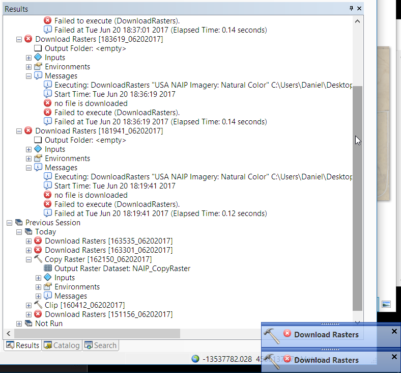
I'm having the same problem - I've tried a dozen times to use both the "download raster" and "copy raster" tools and they fail each time with very little useful error messaging:
Start Time: Tue Jun 20 18:37:01 2017
no file is downloaded
Failed to execute (DownloadRasters).
Failed at Tue Jun 20 18:37:01 2017 (Elapsed Time: 0.14 seconds)
The URL I used is this one: https://naip.arcgis.com/arcgis/services/NAIP/ImageServer
Note - I just now noticed that there is a Maximum Request Size limit set of 4,000 x 4,000 (Column x Row). Maybe that is why? I'll try a smaller image, see how it goes...
- Mark as New
- Bookmark
- Subscribe
- Mute
- Subscribe to RSS Feed
- Permalink
- Report Inappropriate Content
I think the size restrictions are what was getting in the way. I used the "split raster" tool to break up the raster I needed into two tiles and it worked.
- Mark as New
- Bookmark
- Subscribe
- Mute
- Subscribe to RSS Feed
- Permalink
- Report Inappropriate Content
Daniel, how did you use Split Raster with the image service?