- Home
- :
- All Communities
- :
- Products
- :
- ArcGIS Pro
- :
- ArcGIS Pro Questions
- :
- Re: Can I force ArcPro to show an entire polygon w...
- Subscribe to RSS Feed
- Mark Topic as New
- Mark Topic as Read
- Float this Topic for Current User
- Bookmark
- Subscribe
- Mute
- Printer Friendly Page
Can I force ArcPro to show an entire polygon when creating map series?
- Mark as New
- Bookmark
- Subscribe
- Mute
- Subscribe to RSS Feed
- Permalink
- Report Inappropriate Content
Hey,
I have created a map series based on a bunch of polygons, and I want to iterate over these polygons and export a PDF accordingly. This works well on the most part, but on a select few of my polygons, it is rounding to the nearest 2500 scale, but this scale is masking some of my polygon.
In this GIF you can see it is working well for a few polygons, but one of them it is masking the east and western sections which is annoying me.
I have tried percent and centimeters as the best fit extent.
(click to make full screen)
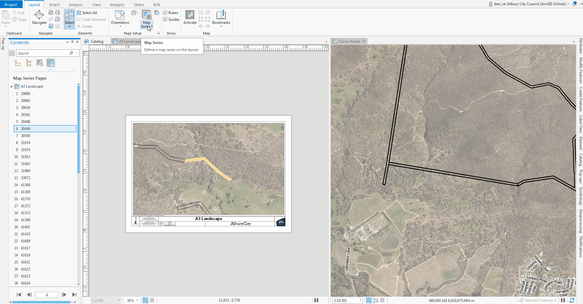
any ideas if I can tell ArcPro to only chose a scale that will show the entire feature?
Cheers
Solved! Go to Solution.
- Mark as New
- Bookmark
- Subscribe
- Mute
- Subscribe to RSS Feed
- Permalink
- Report Inappropriate Content
Hi All,
I'll state this again.
I'm unaware of any bug specific to this issue that was actually submitted to Technical support. Without actual steps/data to reproduce the issue there is very little we can do. As stated above, technical support is better equipped to handle troubleshooting steps and gather bug data than this forum. They can be contacted at https://support.esri.com/en/contact-tech-support.
Thanks,
Tom
- Mark as New
- Bookmark
- Subscribe
- Mute
- Subscribe to RSS Feed
- Permalink
- Report Inappropriate Content
Hey Tom,
This response has unfortunately hit a nerve with me, its not you, its the same attitude I see over and over again on this forum/geonet.
Instead of asking us to jump through hoops to repeat and document an issue with with tech support, for your own software, how about you guys create a bug and reference this thread as documentation? A bit of time goes into creating a post on this forum so that this cohort can assist/trouble shoot, so surely there is enough info for you to replicate.
If you were to create your own polygon feature layer with varying size features and try to create a map series using the same settings in my original post I am sure you will see the issue that several people are now reporting.
Sorry to be specifically targeting your post, its just the straw that broke the camels back (and I might* be going mad working in iso!)
* highly likely
- Mark as New
- Bookmark
- Subscribe
- Mute
- Subscribe to RSS Feed
- Permalink
- Report Inappropriate Content
Hey Ben,
I appreciate your frustration. Please entertain mine. I tried to reproduce the issue with the screenshot you provided. I tried with "skinny, long polygons", "short fat ones", all different shapes and sizes.
I could not reproduce the bug you described.
We test map series against many different kinds of points,lines, polygons as index features, with map frames set for various constraints and maps in different spatial reference systems, against different databases and with all the different dynamic elements that you place on a layout. As you can imagine, there are many variables involved. We try to cover as much ground as we can, but unfortunately we miss things. We have not run across the issue described above.
We generally do not enter bugs for issues we cannot reproduce. Imagine handing an editor a 500 page manuscript and telling them that the word "house" is misspelled. Given enough time I'm sure the editor could find the misspelled word and correct it. But, they might have to read the whole book. It may take a day or a number of days to do depending on how many other books they need to edit. Now, imagine ff they were provided with the page number with the misspelled word.
If we put in a bug that cannot be reproduced the Developer responsible to fix the issue has nothing to work with. Perhaps they come up with a hunch based on the description of the issue and put in a "blind" fix. We test this fix to see if the code change broke any existing functionality, but how do we verify that it actually fixes the problem? We might get lucky, but odds are we would be closing a bug that still exists. A bad situation made worse, in my opinion.
Sometimes we get lucky with a screenshot and the issue can be reproduced . Most times, reproducing the issue requires more information than can be provided by a simple screenshot. Perhaps I'm missing something in translation? Perhaps there is an issue with the underlying geometry of the features that ArcMap handled and that Pro does not? Without more information (data/repro steps) I can only guess at this point.
Tom
- Mark as New
- Bookmark
- Subscribe
- Mute
- Subscribe to RSS Feed
- Permalink
- Report Inappropriate Content
Ben Van Kesteren Rickey Fite and Christi Hallman would any of you be able to send a project package that demonstrates the issue? I can also try to reproduce the issue, but it's usually much faster and to the point to just get the data and settings that show it immediately. If you can share, please send to kkramer@esri.com (if it's too large to email, ping me and I will set up an ftp). If you can't share, and we're still not able to reproduce the issue, we might be at a standstill even though the development team (that Tom is representing) clearly wants to figure this out.
Thank you so much!
- Mark as New
- Bookmark
- Subscribe
- Mute
- Subscribe to RSS Feed
- Permalink
- Report Inappropriate Content
Update on this one! Hey again Ben Van Kesteren Rickey Fite and Christi Hallman I hope that everyone is staying safe and healthy - Ben, I noted your comment about possibly (likely) going mad working in iso, so instead of just typing out this update, I thought I'd make a little video to share what we've found. Though I'm sequestered in my bedroom working all by myself, Tom and I got on a video call and came to some conclusions. See the video: Map Series Best Fit Extent Scale Rounding
So basically it appears that you'll need to work with how you round your scales, given the data you're working with.
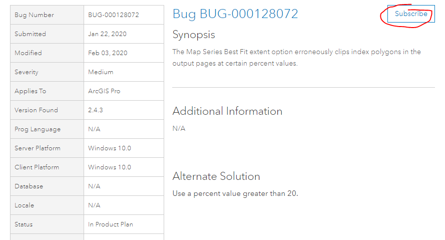
I did manage to find an issue that was submitted to technical support that probably describes what you're seeing: BUG-000128072: The Map Series Best Fit extent option erroneously cl.. The development team will need to discuss whether it will always be the best case to round up vs. rounding to the nearest scale. If the scale rounds up, I think you could end up with scenarios where your margin is bigger than you requested. And the differences will always be exacerbated with larger numbers entered for scale rounding.
I hope this is helpful. Please work with some of the settings I've shown in the video to confirm that you're seeing the same behavior. If so, you can go to the Technical Support page and click Subscribe. This will set you up for notifications on the issue and also increment the number of customers affected.
*Note that the behavior is data-specific and sensitive to scale and margin settings. The workaround listed will not necessarily work for you - you will need to adjust scale rounding to work with your data.
- « Previous
-
- 1
- 2
- Next »
- « Previous
-
- 1
- 2
- Next »