- Home
- :
- All Communities
- :
- Products
- :
- ArcGIS Pro
- :
- ArcGIS Pro Questions
- :
- Re: Can ArcGIS Pro create one mostly blank map wit...
- Subscribe to RSS Feed
- Mark Topic as New
- Mark Topic as Read
- Float this Topic for Current User
- Bookmark
- Subscribe
- Mute
- Printer Friendly Page
Can ArcGIS Pro create one mostly blank map with basemap on for small sections for 100+ locations?
- Mark as New
- Bookmark
- Subscribe
- Mute
- Subscribe to RSS Feed
- Permalink
- Report Inappropriate Content
Hi
Here's the problem:
- I am trying to make a map that is almost 1.5 million km² with the focus of 100+ locations in that area
- All the locations are remote and do not receive internet connection
- I want the map to be space efficient as it will be attached to a Survey123 survey
- Preferably use either OpenStreetMap or Imagery as basemap
*simplified example below*

Is this possible?
Cheers
- Mark as New
- Bookmark
- Subscribe
- Mute
- Subscribe to RSS Feed
- Permalink
- Report Inappropriate Content
l assume that you don't want to clip subsections of the basemap then reassemble them with blank space in between your areas of interest.
... sort of retired...
- Mark as New
- Bookmark
- Subscribe
- Mute
- Subscribe to RSS Feed
- Permalink
- Report Inappropriate Content
James,
If you use OpenStreetMap you may be able to get a vector tile package that will meet your needs.
Using ArcGIS Pro you can use Download Map, to get a Vetctor Tile Package layer of the OSM basemap for your area. The caveat is whether your area is withing the Tile Limit of the service. This article explains the process. /blogs/bock/2019/07/03/using-arcgis-pro-to-put-esri-vector-tile-basemaps-in-your-mobile-map
Once you have the layer, you can use the Create Mobile Map Package tool to clip the vector tile package similar to your picture. In this example I buffered boat ramps by 1 mile, and used the buffer polys to clip the vector tile package.
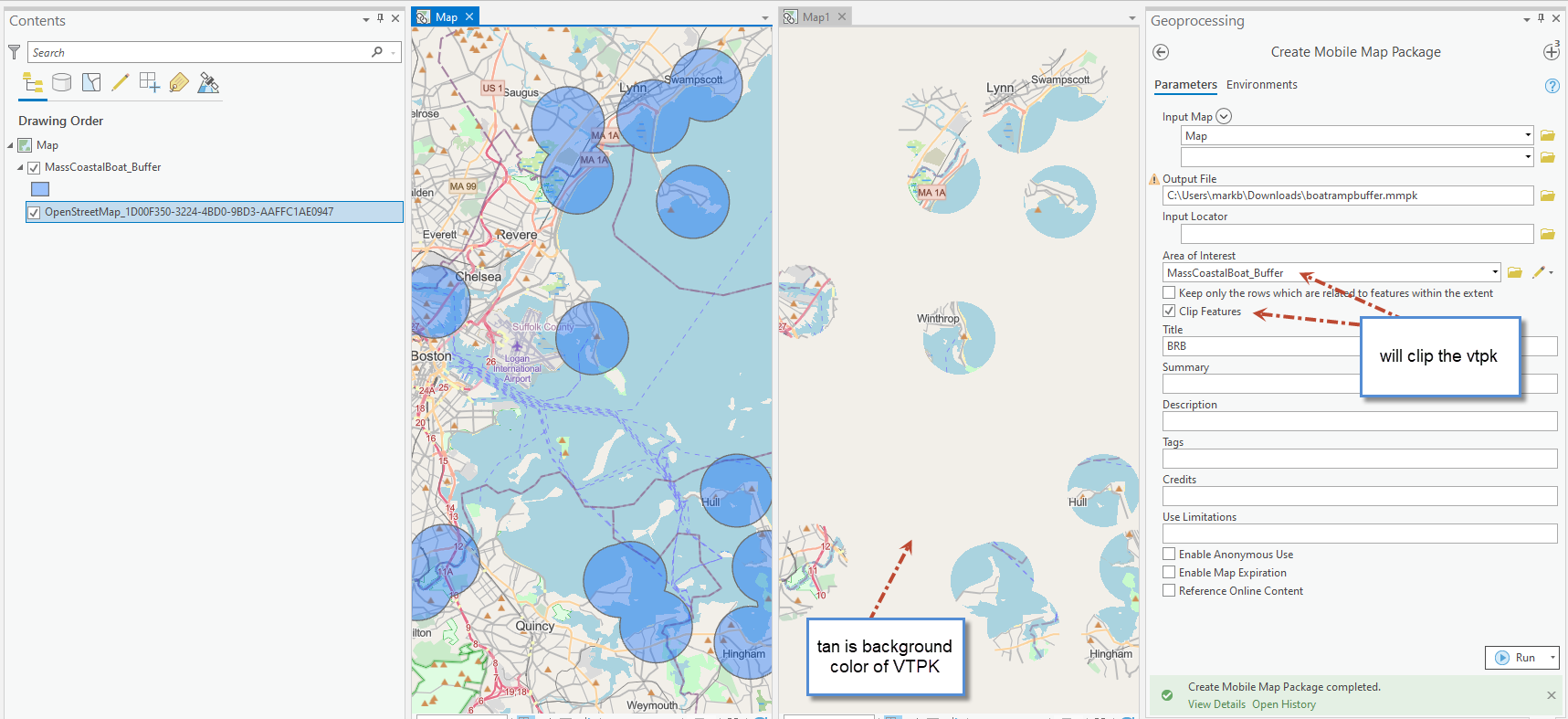
The map on the left is the source, with my buffer polys and the downloaded VTPK. The right is the output MMPK inserted back into Pro. For my area the source VTPK is 215 mb and the output is 90 mb, so its worth clipping if file size is a concern. (note: With OSM VTPK you can unzip the MMPK, and get the VTPK file from inside and use it directly as a basemap in Survey123, Collector or app of choice as side loaded basemap. The OSM style is inside the VTPK file).
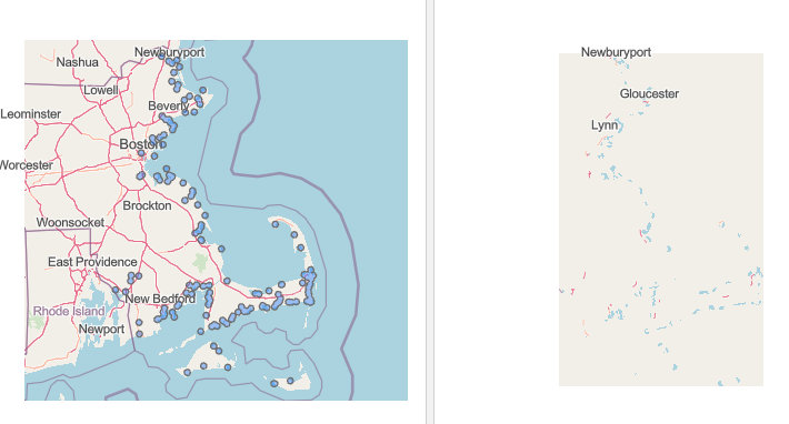
This is the extent for context of the file sizes.
With regard to TPK or TPKX imagery raster it does not clip to polys, so not as easily done.
Mark
- Mark as New
- Bookmark
- Subscribe
- Mute
- Subscribe to RSS Feed
- Permalink
- Report Inappropriate Content
Thanks Mark for your reply, seems a lot more promising than other processes I've tried.
I have a handful of questions regarding your screenshots;
- Is the basemap OpenStreetMap?
- If it is OpenStreetMap, how did you manage to remove the basemap outside the buffer zones as shown in "Map1"?

(note: With OSM VTPK you can unzip the MMPK, and get the VTPK file from inside and use it directly as a basemap in Survey123, Collector or app of choice as side loaded basemap. The OSM style is inside the VTPK file).
How did you manage to get OSM to VTPK? My map only has an OSM basemap turned on and I am prompted with "ERROR 001852: Layer type is not supported for vector tile packages."
Thanks in advance
James
- Mark as New
- Bookmark
- Subscribe
- Mute
- Subscribe to RSS Feed
- Permalink
- Report Inappropriate Content
Hi Mark Bockenhauer
I recently found - https://apl.esri.com/jg/OSMVectorTileExport/index.html
This allows to download of large areas at high level of detail while maintaining low file size thanks to OSM.
It has solved my issue and hopefully helps anyone else down the line.
Cheers