- Home
- :
- All Communities
- :
- Products
- :
- ArcGIS Pro
- :
- ArcGIS Pro Questions
- :
- Re: Calculate - field is not nullable.
- Subscribe to RSS Feed
- Mark Topic as New
- Mark Topic as Read
- Float this Topic for Current User
- Bookmark
- Subscribe
- Mute
- Printer Friendly Page
Calculate - field is not nullable.
- Mark as New
- Bookmark
- Subscribe
- Mute
- Subscribe to RSS Feed
- Permalink
- Report Inappropriate Content
Hello,
I am working on a shapefile within ArcGIS Pro 2.1. I am trying to use the field calculator to add a few fields to the populated one I created. However, I keep getting the error message of field is not nullable.
Can anyone tell me what I am doing wrong?
Thanks,
Derek
- Mark as New
- Bookmark
- Subscribe
- Mute
- Subscribe to RSS Feed
- Permalink
- Report Inappropriate Content
shapefile fields are not nullable
you have to use a featureclass in a file geodatabase if you need that capability
- Mark as New
- Bookmark
- Subscribe
- Mute
- Subscribe to RSS Feed
- Permalink
- Report Inappropriate Content
Thanks Dan. I had read that and was wondering if that was of issue. I did move it to a geodatabase at one point, but I think I was getting the same issue. I will try it again. A perplexing thing is that my calculations should be producing any nulls unless field calculator is treating 0+0+0 as null.
- Mark as New
- Bookmark
- Subscribe
- Mute
- Subscribe to RSS Feed
- Permalink
- Report Inappropriate Content
Moving to a geodatabase won't 'fix' the issue, you will probably have to create new fields since Alter Field only works on empty tables.
Moving from a shapefile to a geodatabase is sketchy at best if people haven't been careful to assign nulls in the shapefile properly.
0 (zero) is the default for numeric field... sadly 0 is a valid observation and a valid number, it is totally unsuitable as a null as is the <null> itself in my opinion.
Even in a geodatabase, you would be advised to use the largest or smallest integer possible for you operating system (ie 32 bit integers (min=-2147483648, max=2147483647, dtype=int32) and the same for float/doubles (min=-1.7976931348623157e+308, max=1.7976931348623157e+308, dtype=float64) It just kind of makes things obvious that they just aren't 'observations' or 'measurements'
- Mark as New
- Bookmark
- Subscribe
- Mute
- Subscribe to RSS Feed
- Permalink
- Report Inappropriate Content
What values do you have for city_ords, prohib_in_ and prohib_by_ for those records that yield the error?
What field type do you have for those 3 input fields and the output field?
- Mark as New
- Bookmark
- Subscribe
- Mute
- Subscribe to RSS Feed
- Permalink
- Report Inappropriate Content
The values on those fields (both Long type) on are 0 or 1. I feel like I am doing something wrong with my calculate field statement. Like most folks, I am new to ArcGIS Pro. I added a new Long field to hold the results of the sum. Then I right-click on that new field and select Calculate Field. From there I put in the build up in the first input box following the new_field= something like !city_ords! + !county_ord!. I leave the default of Python 3 as the expression type. But, everything I get nulls in the result of the new field. I am able to get it to run in a geodatabase as Dan suggested, but the values are still null.
- Mark as New
- Bookmark
- Subscribe
- Mute
- Subscribe to RSS Feed
- Permalink
- Report Inappropriate Content
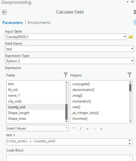
!city_ords! + !county_ord!
would be the only part you should put in the expression section
You might want to put in a screen grab of exactly what you want.
And make sure that all the fields are numeric.
If one of the row values is null, then the result will be null
- Mark as New
- Bookmark
- Subscribe
- Mute
- Subscribe to RSS Feed
- Permalink
- Report Inappropriate Content
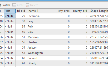
I am doing this now in a geodatabase and am verifying that the fields are all of the type numeric. From the screenshot below you can see the zeros in the table. There are some 1's further down in the table.
Here is the setup I do:
Here is the result of the table
Thanks for all of your feedback and suggestions. I am just trying to learn some of the subtle nuances of ArcGIS here.
Derek
- Mark as New
- Bookmark
- Subscribe
- Mute
- Subscribe to RSS Feed
- Permalink
- Report Inappropriate Content
Is this a joined table?
CountyENDS:1 is a strange table name
you fields are out of order so that might be due to a join unless you rearrange things
Something is amiss.
I would copy those values to new fields (ie make a new field and do the newfield = oldfield thing), so that you have a clean file without joins (if indeed you have them) since you can only calculate values in the destination table, and not the table that you are joining over.
- Mark as New
- Bookmark
- Subscribe
- Mute
- Subscribe to RSS Feed
- Permalink
- Report Inappropriate Content
This layer is not currently in a joined state. I believe the CountyENDS:1 is occurring because I have another layer added to the same project with the same name. One is from a standalone shapefile and the other is within a geodatabase, but they both have the same names. I think that Field Calculate tool just adds that :# on there from multiple layers with the same name.