- Home
- :
- All Communities
- :
- Products
- :
- ArcGIS Pro
- :
- ArcGIS Pro Questions
- :
- Re: Basemap imagery collection date in Pro?
- Subscribe to RSS Feed
- Mark Topic as New
- Mark Topic as Read
- Float this Topic for Current User
- Bookmark
- Subscribe
- Mute
- Printer Friendly Page
Basemap imagery collection date in Pro?
- Mark as New
- Bookmark
- Subscribe
- Mute
- Subscribe to RSS Feed
- Permalink
- Report Inappropriate Content
How do you find out the date of collection for basemap imagery in Pro? Bonus: is there a way to do it via ArcGIS Online, too?
Tried Explore tool, looked through metadata and just can't seem to find it.
- Mark as New
- Bookmark
- Subscribe
- Mute
- Subscribe to RSS Feed
- Permalink
- Report Inappropriate Content
Try this for online: http://www.arcgis.com/home/item.html?id=c1c2090ed8594e0193194b750d0d5f83
Currently, no way to do this in Pro. It would be worth logging an enhancement or equivalency issue with technical support.
- Mark as New
- Bookmark
- Subscribe
- Mute
- Subscribe to RSS Feed
- Permalink
- Report Inappropriate Content
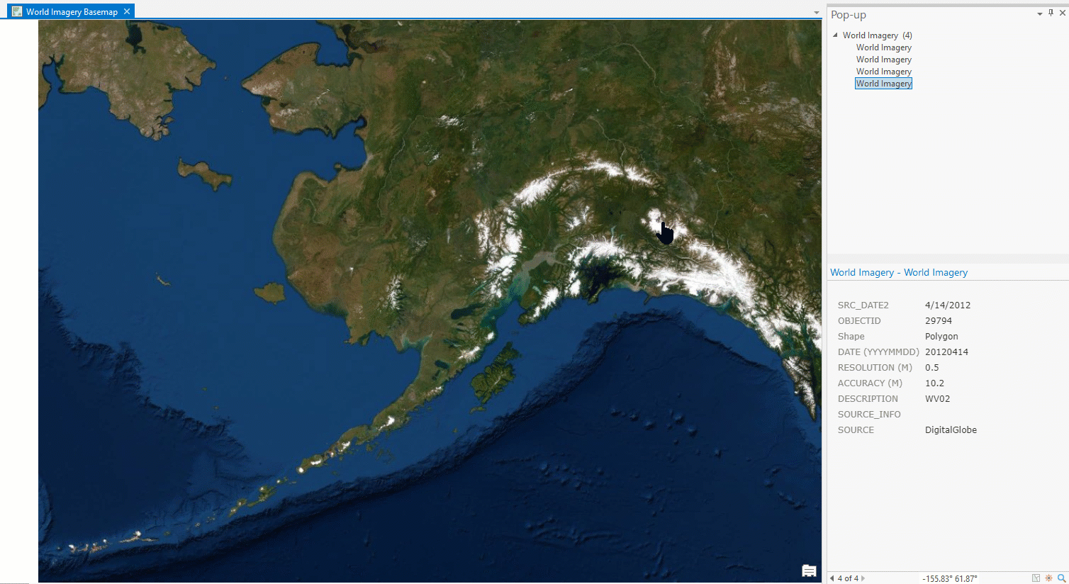
In AGOL, you simply add the imagery basemap as a new layer to your map (Search For Layers->"World imagery"). When you click the map, the infoWindow will tell you the acquisition date, source, etc of the imagery.
- Mark as New
- Bookmark
- Subscribe
- Mute
- Subscribe to RSS Feed
- Permalink
- Report Inappropriate Content
This doesn't work for me in the latest version of ArcGIS pro. The popoup window or the metatadata does not include the date field that you can get using the Identify Tool in ArcMap.
- Mark as New
- Bookmark
- Subscribe
- Mute
- Subscribe to RSS Feed
- Permalink
- Report Inappropriate Content
https://community.esri.com/ideas/15373-enable-metadata-functionality-for-basemap-layers
I think that this is going to be worked on for ArcGIS Pro 2.5 (so not the release next week, but after that).
- Mark as New
- Bookmark
- Subscribe
- Mute
- Subscribe to RSS Feed
- Permalink
- Report Inappropriate Content
Thanks for the reply, I did just get an email from an ESRI developer confirming that this capability will be coming in the 2.5 release as well.
- Mark as New
- Bookmark
- Subscribe
- Mute
- Subscribe to RSS Feed
- Permalink
- Report Inappropriate Content
Seems that this functionality is still not available at 2.5
- Mark as New
- Bookmark
- Subscribe
- Mute
- Subscribe to RSS Feed
- Permalink
- Report Inappropriate Content
Looks that way to me as well  I don't understand why this functionality is so hard to add as it already exists in ArcMap.
- Mark as New
- Bookmark
- Subscribe
- Mute
- Subscribe to RSS Feed
- Permalink
- Report Inappropriate Content
Hi guys. Sorry that it took a bit to get this in - it was part of a larger project about how Pro handles sublayers of services, but we do see it in 2.6 (next release of ArcGIS Pro).
- Mark as New
- Bookmark
- Subscribe
- Mute
- Subscribe to RSS Feed
- Permalink
- Report Inappropriate Content
This article provides a work-around for now... thought I'd share it here: