- Home
- :
- All Communities
- :
- Products
- :
- ArcGIS Pro
- :
- ArcGIS Pro Questions
- :
- Are negative values possible for the coordinates o...
- Subscribe to RSS Feed
- Mark Topic as New
- Mark Topic as Read
- Float this Topic for Current User
- Bookmark
- Subscribe
- Mute
- Printer Friendly Page
Are negative values possible for the coordinates of the principal point (ortho mapping)?
- Mark as New
- Bookmark
- Subscribe
- Mute
- Subscribe to RSS Feed
- Permalink
- Report Inappropriate Content
If I’d like enter the optical parameters for a new ortho mapping workspace and I’d like to define the plain coordinates of the principal point of the measuring camera there is no indication for the unit or origin. Actually the adjustment report of an existing ortho mapping workspace helped me a lot: it says “… Position of the Principal Point is referenced to the physical center of the image plain. …”. And there is a table before this statement indicating the coordinates of the principal point is measured in millimeters. It would be quite helpful to indicate these information on the wizard’s GUI.
But the real problem arises after that. If the position of the principal point is measured from the physical center of the image plain (center of the sensor) than the coordinates could be either positive or negative. But I can’t enter negative values at all. Same problem at the Konrady (or Brown-Conrady -- as the adjustment report says?) constants. Maybe I misunderstood something (?).
Ákos Halmai
Solved! Go to Solution.
Accepted Solutions
- Mark as New
- Bookmark
- Subscribe
- Mute
- Subscribe to RSS Feed
- Permalink
- Report Inappropriate Content
Ákos Halmai,
Thank you for using Pro Ortho Mapping. Pro Ortho Mapping supports multiple types of data sources, satellite, aerial photographs, and drones. You didn't indicate specifically what type of data you are using, but I guess you are using drone images.
The unit for principle point is millimeter and the origin is at the center. The following diagram will help to understand
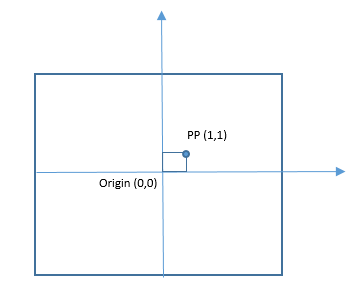
For drone images, the adjust calculation will automatically adjust the principle point and image orientation if it is 0. so if the principal point is close to the center, it is ok to leave it as 0. Yes the software allows to enter one a user defined one, and should allow negative value. I will submit a change request for this defeat.
Thanks,
Hong from raster team.
- Mark as New
- Bookmark
- Subscribe
- Mute
- Subscribe to RSS Feed
- Permalink
- Report Inappropriate Content
Ákos Halmai,
Thank you for using Pro Ortho Mapping. Pro Ortho Mapping supports multiple types of data sources, satellite, aerial photographs, and drones. You didn't indicate specifically what type of data you are using, but I guess you are using drone images.
The unit for principle point is millimeter and the origin is at the center. The following diagram will help to understand
For drone images, the adjust calculation will automatically adjust the principle point and image orientation if it is 0. so if the principal point is close to the center, it is ok to leave it as 0. Yes the software allows to enter one a user defined one, and should allow negative value. I will submit a change request for this defeat.
Thanks,
Hong from raster team.