- Home
- :
- All Communities
- :
- Products
- :
- ArcGIS Pro
- :
- ArcGIS Pro Questions
- :
- Re: ArcMap vs ArcGIS Pro calculating geometry Degr...
- Subscribe to RSS Feed
- Mark Topic as New
- Mark Topic as Read
- Float this Topic for Current User
- Bookmark
- Subscribe
- Mute
- Printer Friendly Page
ArcMap vs ArcGIS Pro calculating geometry Degrees Minutes Seconds
- Mark as New
- Bookmark
- Subscribe
- Mute
- Subscribe to RSS Feed
- Permalink
- Report Inappropriate Content
Hi there,
I am observing differences in how ArcGIS Pro calculates geometry/coordinates in DMS (degrees minutes seconds).
The process in ArcMap was very straight forward:
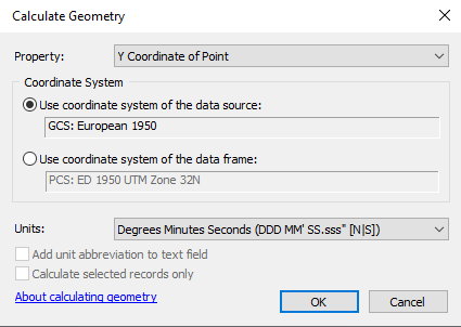
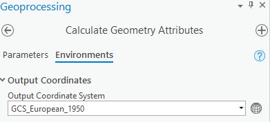
While in ArcGIS Pro, you have to also double check and set the environmental settings:
Now these are the results:
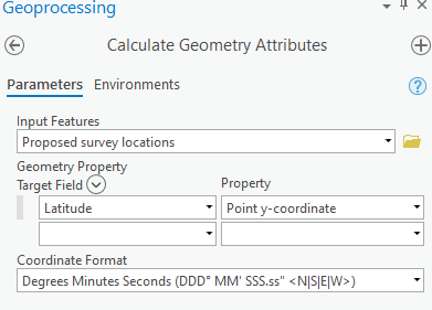
ArcGIS Pro
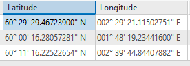
ArcMap
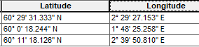
The seconds are always different. Sure, it is just a couple of seconds but still, why is there a difference in the results of the calculation?
The issue is that we are providing colleagues and customers with the coordinates who themselves plot them into their software and then we get quite some deviation.
Solved! Go to Solution.
Accepted Solutions
- Mark as New
- Bookmark
- Subscribe
- Mute
- Subscribe to RSS Feed
- Permalink
- Report Inappropriate Content
Is the same transformation used? Melita Kennedy addressed this in the on-the-fly projection differences between ArcMap and ArcGIS Pro and it might apply here, too
- Mark as New
- Bookmark
- Subscribe
- Mute
- Subscribe to RSS Feed
- Permalink
- Report Inappropriate Content
another reason why we use ArcMap for the heavy lifting.
- Mark as New
- Bookmark
- Subscribe
- Mute
- Subscribe to RSS Feed
- Permalink
- Report Inappropriate Content
Is the same transformation used? Melita Kennedy addressed this in the on-the-fly projection differences between ArcMap and ArcGIS Pro and it might apply here, too
- Mark as New
- Bookmark
- Subscribe
- Mute
- Subscribe to RSS Feed
- Permalink
- Report Inappropriate Content
The 'Calculate Geometry' field calculator was always a bit disturbing, with no transformation options I could see. For transforming survey coords I'm not sure it would have been my go-to method.
- Mark as New
- Bookmark
- Subscribe
- Mute
- Subscribe to RSS Feed
- Permalink
- Report Inappropriate Content
We have a case with Esri support on this now and have a first workaround. As Ken Buja correctly stated, it is also a transformation issue.
Our data is in projected coordinate systems (ED50, UTM zones), and as default in our Pro project do we have the topographic basemap (WGS 1984 Web Mercator (auxiliary sphere)).
Because your basemap is a different coordinate system, you also have a transformation.
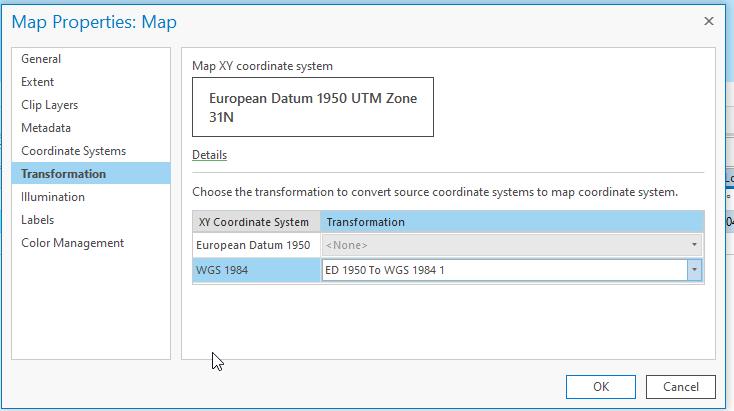
By removing the transformation in the map properties (change it to <none>), the calculations are correct. So the short workaround is: remove the transformation.