- Home
- :
- All Communities
- :
- Products
- :
- ArcGIS Pro
- :
- ArcGIS Pro Questions
- :
- Re: ArcGIS Pro - Calculate Geometry just does noth...
- Subscribe to RSS Feed
- Mark Topic as New
- Mark Topic as Read
- Float this Topic for Current User
- Bookmark
- Subscribe
- Mute
- Printer Friendly Page
ArcGIS Pro - Calculate Geometry just does nothing, but says there is no error.
- Mark as New
- Bookmark
- Subscribe
- Mute
- Subscribe to RSS Feed
- Permalink
I need to calculate the area of polygon features in my map. I've done this hundreds of times. For some reason now, when I run everything the same way that I always do, the field that I calculate area into just stays "0" and the tool says it successfully ran. I tested out calculating other geometry attributes, made sure that the field type was correct, deleted and recreated the field, tried it on multiple maps, and it just no longer does anything at all. I can measure area using the measure tool, but it would be inconvenient to have to trace my polygons.
- Mark as New
- Bookmark
- Subscribe
- Mute
- Subscribe to RSS Feed
- Permalink
Use
Add Geometry Attributes—Data Management toolbox | Documentation
carefully selecting the things your want including you length, area units and the coordinate system.
It handles adding the fields, in case there is some issue there.
If that tool fails. Stop, close, restart AND try on another file. If that succeeds, try it on the file you want the information in. If that doesn't work, Tech Support and file a support case, they may need a zip and ship copy of the files
- Mark as New
- Bookmark
- Subscribe
- Mute
- Subscribe to RSS Feed
- Permalink
And double check that your layer doesn't have a selection, definition query, etc that limits which records are processed by the geoprocessing tool. You can switch, instead of using the layer as input, browse and select the feature class on disk so you know you are working against the full dataset.
Aside from this, I don't see any reason the tool shouldn't work to calculate the values. Dan's comment about tech support with your data is the best thing.
- Mark as New
- Bookmark
- Subscribe
- Mute
- Subscribe to RSS Feed
- Permalink
Just to add that I have also experienced this before when making changes to environment settings under Analysis > Environments that then results in the outputs of the GP tool falling outside of the Environments settings.
- Mark as New
- Bookmark
- Subscribe
- Mute
- Subscribe to RSS Feed
- Permalink
Specifically, I imagine, the Processing Extent (or potentially the raster analysis mask for raster tools)?
I just tested Calculate Geometry, and it isn't impacted by the extent (and is documented as such), though many tools will be so your comment is definitely valid.
- Mark as New
- Bookmark
- Subscribe
- Mute
- Subscribe to RSS Feed
- Permalink
Hi Drew
Yes indeed, it was Processing Extent ... and I realise now that this question related to Calculate Geometry, which would not be impacted by extent limits. My error.
- Mark as New
- Bookmark
- Subscribe
- Mute
- Subscribe to RSS Feed
- Permalink
Rita Hodges Were you able to resolve this? I've been having the same problem this evening (and to confirm, it's not populating the column with "0": I've tried running it on other populated columns and got no change). Nothing is happening.
First of all, I'm very green, and though I'm sure I've done this before in a MOOC, I can't find the lesson now to confirm how I did it, but I feel like there's not too much I can screw up here: as far as I know it should just be calculating and depositing the numbers in the column I made for the purpose, but it's not! It says it's running the process in less than a second, and I know that's not possible (I've added a bunch of islands that even if it had the unedited values cached, it would take more than a second to calculate, and since I'm pretty sure that's not the case, I'm expecting this to take several minutes if not hours!).
This originally is the "ne_10m_admin_0_countries" dataset, so I don't know if there's something there that limits me? Also it was missing Cabo Verde poly so at some point I merged in the Cabo Verde layer found on the CV government site: The same problem occurs when I run the tool on that data. And though I did a complete botch job on merging them (the columns were/still are a mess) I don't see how that or anything else on either of those should stop the CGA tool from running.
Also, I'd like to confirm that this task is run locally, that this isn't some sort of network/credit issue.
Beyond that I'm at a loss. I even restarted my system. Drew Flater I'm not sure "the layer doesn't have a selection, definition query, etc that limits which records are processed by the geoprocessing tool", but the way I understand it, if I can see in the map pane it's seen by the tool process as well no?
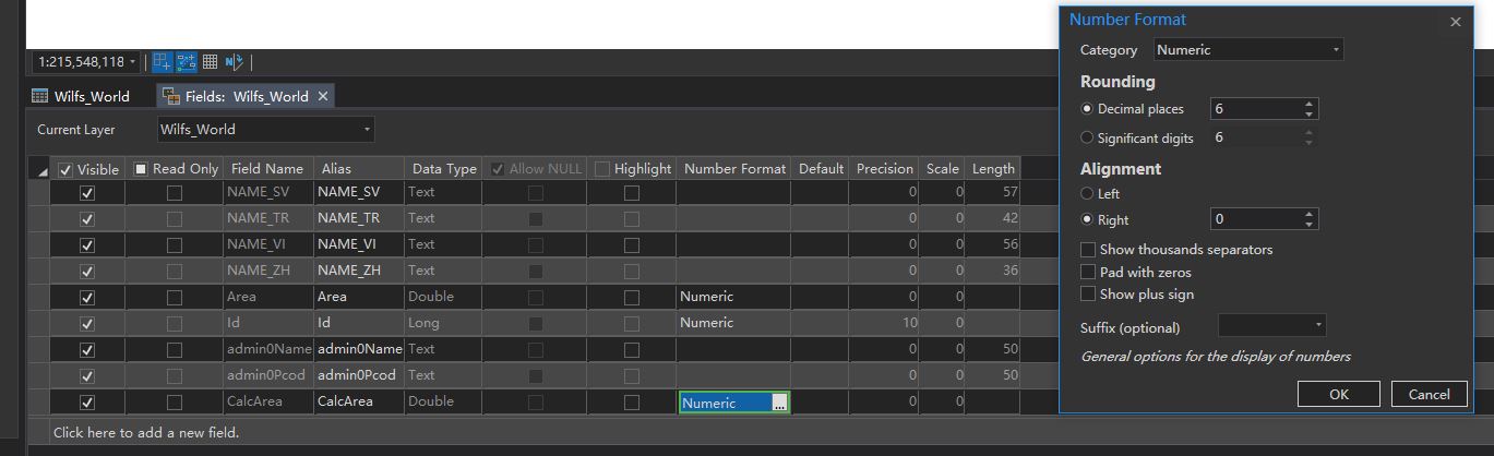
Here's some screens to make sure I'm not missing something obvious. 
- Mark as New
- Bookmark
- Subscribe
- Mute
- Subscribe to RSS Feed
- Permalink
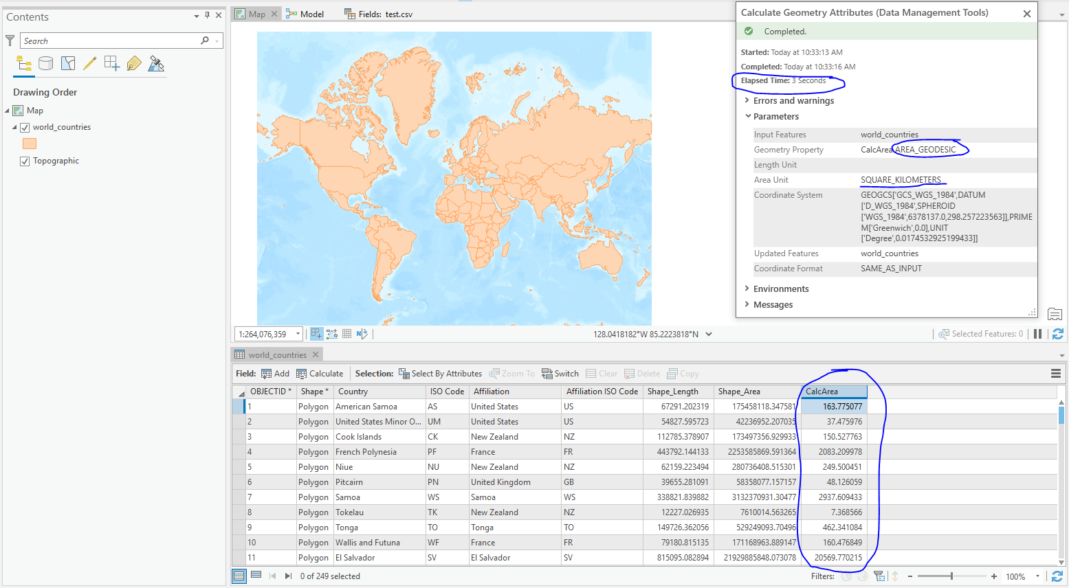
Wilfred Darr you appear to have all the features selected so all of them should be calculated. Would you be able to upload the feature class in question for me to debug? What software version are you using?
Just for some sanity, I ran Calculate Geometry using a local file gdb World Countries feature class, using similar parameters to what you showed, and it completed successfully in 3 seconds.
- Mark as New
- Bookmark
- Subscribe
- Mute
- Subscribe to RSS Feed
- Permalink
I didn't hear from you so I went and uninstalled ArcGIS, which was an exercise in itself: the uninstaller had the same issues with my removable drive as the updater was having. I ended up having to re-letter my drive and then that all worked. I wish after re-lettering my drive to 😧 that I would have tried the Calculate Geometry function, because at this point, everything else acted as predicted so I'm guessing it would have as well. At any rate, after reinstalling the Calculate Geometry function is acting exactly as it should (and ya it only takes about 10 seconds to run all the geometry in my file).
Thanks for taking your time to look at this.
Sincerely
Wilf
- Mark as New
- Bookmark
- Subscribe
- Mute
- Subscribe to RSS Feed
- Permalink
Thanks for your quick reply.
Oh, that's a lot faster than I was expecting (we ran the generalize tool on what was (I thought at least) a small data set in a MOOC IIRC and it took 3-15 minutes for the students depending on the rig (I'm using a laptop) so I was expecting area calculations on all the weird areas to take longer than 3 seconds (even interpolating for my laptop it should take less than a minute then?).
As for the version, I'm using Pro 2.5.1: I did try and update that last night but I have it installed on Drive E: and the installer gets broken by that (Error 1327 Invalid Drive D:) Their response on the support ticket this morning was to uninstall my Drive E: version and install on my Drive C:. Not the solution I was looking for, but I wonder if that could be part of the issue as well if it's not designed to be run off Drive E:? I have not found any other issues due to it being installed on Drive E:, this would be the first. I'll leave it as is until I hear again from you, but if I don't hear from you by the weekend I'll update then
I've tried a new project with a fresh GDB and added that shape but it does the same thing, so I don't think its the GDB unless my ArcGIS Pro is building bad GDBs for some reason (again could the Drive E: be the issue?).
I can't upload folders to the forum, so I'm going to share it via Google Drive: Wilfs_World contains my global shapes etc. including the Wilfs_World Multi-poly Shape in question, and the Kids Globe Project has the GDBs etc.
Kids Globe Project - Google Drive
Thanks again for taking the time on this.
Sincerely
Wilf