- Home
- :
- All Communities
- :
- Products
- :
- ArcGIS Pro
- :
- ArcGIS Pro Questions
- :
- ArcGIS Pro 2.0 | How to author map symbols?
- Subscribe to RSS Feed
- Mark Topic as New
- Mark Topic as Read
- Float this Topic for Current User
- Bookmark
- Subscribe
- Mute
- Printer Friendly Page
ArcGIS Pro 2.0 | How to author map symbols?
- Mark as New
- Bookmark
- Subscribe
- Mute
- Subscribe to RSS Feed
- Permalink
- Report Inappropriate Content
In ArcGIS 10.5.1, for producing printed maps, I usually right-click layers and "convert features to graphics" in order to edit symbols in cluttered area. In addition, instead of converting into Annotation Groups in which there is no control on ordering, I "convert features to graphics" into empty Annotation Feature Class, stored in my project File GDB. It works well.
In ArcGIS Pro .aprx projects, unfortunately, Annotation Groups (formely stored in .mxd with ArcMap) do not exist. I thought I could still convert features to graphics in Annotation Feature Class with ArcGIS Pro but I cannot find any function to do that. I am stuck!
In ArcGIS Pro, there must be a way to "convert" symbol to graphics for editing? At least I would expect the equivalent of Cartographic representation but I cannot find it either. And Cartographic representation usually needs a Standard or Advanced license.
Any help is very welcome
- Mark as New
- Bookmark
- Subscribe
- Mute
- Subscribe to RSS Feed
- Permalink
- Report Inappropriate Content
From a workflow standpoint, this only differs from editing graphics in that you're editing features now instead.
I disagree. Here's a good example why "Attribute Driven Symbology" is preventing my migration to Pro. I have hundreds of road gates to map. On our current cartographic product, we always show the gate as closed using representation, to indicate that a) there's a gate you CAN close; b)you might need a key; or c) drive a big enough fire truck to plow through a gate, should one be found locked before you. In other words, depicting gates in a common and easy to see cartographic style has a public safety need.
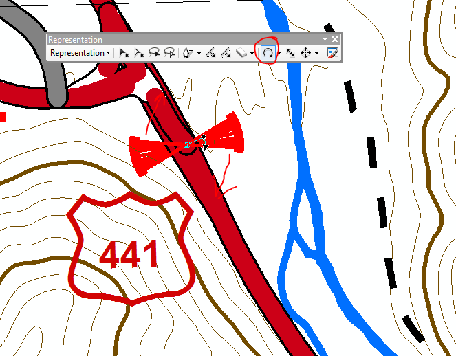
In ArcMap, this is easy. All my gates are points, they intersect the road, I use the representation rotate tool to rotate the gate perpendicular to the road.
According to this, the only way I can do that in Pro is by picking a value or direction ...which I'd have to assign to each point, after measuring the angle of the intersection of the road and the point (for some 450 gates). And yes, gates come, go, and move so I need to update this infrequently.
Here's a more complex example, which, unless I'm missing a really obvious "button" or "menu", is not reproducible in Pro. Here I can move all my representation symbols away from the feature(s) being represented, align them, make them the same size, rotate them (all at once), and place them where they exhibit the least distortion from what the viewer needs to see in terms of geography. If I don't like where all 8 "symbols" are, I can select all 8 of them, once I've spent 15 minutes aligning, rotating, and scaling, I can drag all 8 around to the point where they convey that you will find these 8 services, and not cover up other geographic features.
I do agree with
It looks like ArcGIS Pro has not (yet) been designed for users with traditional mapping workflows
It would he helpful, if Pro 2.3 or 2.whatever was the "We're focusing on cartography release" version.
- Mark as New
- Bookmark
- Subscribe
- Mute
- Subscribe to RSS Feed
- Permalink
- Report Inappropriate Content
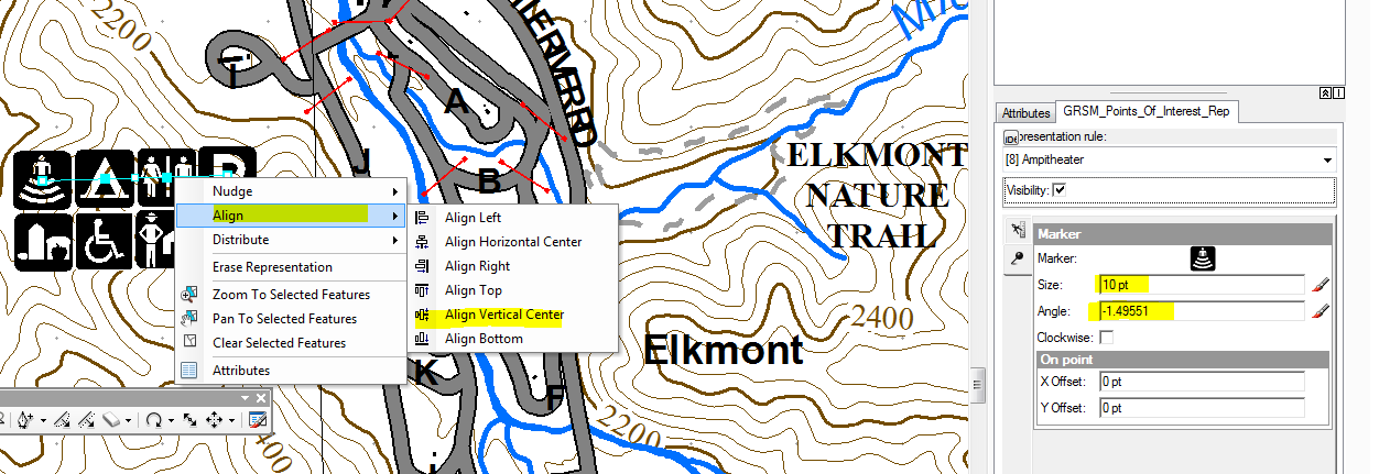
In the future, rotation of a point should update the rotation of rotated 2D symbols. This will make your workflow equivalent with representations. That said, your workflow could be automated with the Align Marker to Stroke Or Fill tool which can automate the rotation of Point symbols to be perpendicular to the line.
The graphic style alignment tools are not implemented yet, but Representations are not specifically needed to achieve this.
We've been working on cartographic functionality in every release of ArcGIS Pro. Every release has been a "focusing on cartography" release, but we have more to add.
- Mark as New
- Bookmark
- Subscribe
- Mute
- Subscribe to RSS Feed
- Permalink
- Report Inappropriate Content
Craig Williams the Align Marker to Stroke Or Fill does not replicate the behavior of representation symbology. The tool gets applied to the entire dataset in a one-size-fit-all approach, and only allows one line feature as input, whereas I'm using as many as 4 different road line representations (public road, private road, trail, road we can't acknowledge exists....) cartographically....representation symbology allows a cartographer precise refinement of each individual symbol. Additionally, I may need to move a symbol placement up to several map units away from its true location, as I exemplified with the second part of my previous example. I'm not able to find the Pro symbology property or GP tool that allows this degree of cartographic control. I would love to see a demonstration how the ArcMap representation functionality is accomplished in Pro, are you able to post a screen recording showing this? I also disagree with this "...we've found that a large number of organizations use derived data and edit the data to provide custom placement of symbols. From a workflow standpoint, this only differs from editing graphics in that you're editing features now instead." Who willingly maintains two divergent copies of the same data? What? That's why representation was added to ArcMap in the first place, so one could symbolize one dataset many different ways.
- Mark as New
- Bookmark
- Subscribe
- Mute
- Subscribe to RSS Feed
- Permalink
- Report Inappropriate Content
Align Marker to Stroke Or Fill automated the setting of the rotation value. That is what I was stating. If you've split your road classes into separate layers, you may need to run it more than once. It's still faster than an initial hand edit. Additional hand edits could be made afterward.
As stated above, symbol rotation is not set when rotating a point as with representations, this is something we'll look at for a future release.
If you're a heavy user of shape overrides, this functionality is not present in ArcGIS Pro symbology.
As for those who make copies of geometry, it's very common in multi-scale map production across a variety of organizations.
- Mark as New
- Bookmark
- Subscribe
- Mute
- Subscribe to RSS Feed
- Permalink
- Report Inappropriate Content
Totally agree.
Pro, for now, focused on 3D and web but totally forget us the traditional mapping cartographer.
Cartography still important for many Esri users like us.
At first I was thinking that it was me who lack knowledge of features and miss something. After the arcmap to arcgis pro transition course, I saw that it’s Esri who leave us behind.
For us, anyway, we have no use for the web or 3D so, Pro have no use.
- Mark as New
- Bookmark
- Subscribe
- Mute
- Subscribe to RSS Feed
- Permalink
- Report Inappropriate Content
What functionality is missing for your needs?
- Mark as New
- Bookmark
- Subscribe
- Mute
- Subscribe to RSS Feed
- Permalink
- Report Inappropriate Content
I spent some time trying to figure out where the "convert features to graphics" tool was at as well, to no avail. The basic functionality that I need, and I believe the others are referring to, is the simple ability to convert symbols to graphics and move them around. For example, when I am identifying multiple locations, and two of the locations are right on top of each other, the symbols cover each other up. When I was using ArcMap, I would simply convert them to graphics, put a tail on them, and spread them apart. It does not seem like I can do this in ArcGis Pro. Please prove me wrong on this.
- Mark as New
- Bookmark
- Subscribe
- Mute
- Subscribe to RSS Feed
- Permalink
- Report Inappropriate Content
I have to agree to all the other members posting to this site. In my organization we still produce "print ready" maps for presentations. In ArcPro there is not a good way to move symbols that overlap each other. It is very bad practice to use the edit tool to move the symbol since it is moving the GPS coordinates also. This means that we need to produce duplicate layers every time we want to change a symbol so that we have an original layer with the correct coordinates, in case we change the map extent. (I have not been able to try the Disperse Maker tool since I do not have the license for it.)
Currently, my workflow consists of exporting a finished map from Pro into a PDF and then opening the PDF in Acrobat. I then have to click on every symbol and move it, a tedious task no less! A task that also needs to be repeated every time there is a change in a map. Moving symbols can now take up a couple of hours in my work day.
- Mark as New
- Bookmark
- Subscribe
- Mute
- Subscribe to RSS Feed
- Permalink
- Report Inappropriate Content
Hi,
I started this thread 2 years ago when I upgraded to ArcGIS Pro. I made a long way since and appreciate ArcGIS Pro in general. BUT for authoring map symbols, things are perhaps worse now! Would you believe... I am currently with Pro 2.4.3 and I cannot simply move my point symbols (.emf file symbols) to deal with overlaps and so on... It is terrible. Unless I miss something new, I feel stuck. Does anybody has find a workaround?
- Mark as New
- Bookmark
- Subscribe
- Mute
- Subscribe to RSS Feed
- Permalink
- Report Inappropriate Content
Unfortunately no. My workflow still consists of either creating a second layer and moving the symbols via the editing tool or by creating a PDF and moving them in Adobe.
I've heard rumors that ESRI is trying to create a fix for this, but nothing too concrete so far. My best suggestion is to keep bringing it up to ESRI and your ESRI account manager. Hopefully enough squeaky wheels will get some solutions!